
CON-130 · Lesson 8 of 12 · 34 min
Surveying and layout calculations
Before anything is built, it is laid out: the position of the building, its grid lines, its floor elevations and the grades of the ground around it are transferred from drawings to the site. Professional land surveyors establish legal boundaries and control points, and on larger projects a survey crew does the layout, but construction managers and superintendents must understand the calculations well enough to check them, to set simple layout themselves and to spot errors before concrete is placed. This lesson covers the arithmetic of differential levelling, cut and fill at grade stakes, stations and chainage along a line, offsets and batter boards, and coordinate geometry: distances, directions and areas calculated from coordinates.
Elevations and benchmarks
An elevation is a height above a reference surface, called a datum. Projects use either a geodetic datum, a national reference close to mean sea level, or a local project datum, such as a main floor set at 100.000. A benchmark is a stable, recorded point of known elevation from which other elevations are measured. Every project should have at least two benchmarks, so that one can be checked against the other and so that work can continue if one is disturbed.
Because heights are differences, the arithmetic of levelling is mostly addition and subtraction. The care lies in recording readings correctly, checking the arithmetic and closing back on a known point to confirm that no reading was misread or misrecorded.
Differential levelling
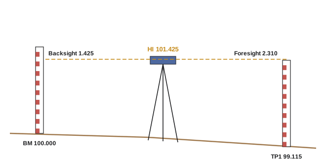
In differential levelling, a level instrument is set up so that its line of sight is horizontal. A graduated rod is held on the benchmark and read: this reading is a backsight (BS). Adding the backsight to the benchmark elevation gives the height of instrument (HI), the elevation of the line of sight. The rod is then held on a point whose elevation is wanted and read: this is a foresight (FS). Subtracting the foresight from the height of instrument gives the point's elevation.
When the line of sight cannot reach the destination, the level is moved. A turning point (TP), a stable temporary point, is read as a foresight from the first set-up and then as a backsight from the next. The arithmetic check for a level run is that the sum of the backsights minus the sum of the foresights equals the last elevation minus the first. This confirms the arithmetic but not the readings, which is why a level run is normally closed back on the starting benchmark or on a second benchmark.
Worked problem
A level run and closure check
A level run starts on BM1 (elevation 100.000 m). Readings: BS on BM1 = 1.425; FS on TP1 = 2.310; BS on TP1 = 0.875; FS on point A = 1.640. (a) Find the elevation of TP1 and A. (b) Check the arithmetic. (c) The design elevation at A is 98.900 m. Is A in cut or fill, and by how much?
Show solution
- (a) HI1 = 100.000 + 1.425 = 101.425; TP1 = 101.425 − 2.310 = 99.115.
- HI2 = 99.115 + 0.875 = 99.990; A = 99.990 − 1.640 = 98.350.
- (b) ΣBS = 1.425 + 0.875 = 2.300; ΣFS = 2.310 + 1.640 = 3.950; ΣBS − ΣFS = −1.650 = 98.350 − 100.000. The arithmetic checks.
- (c) Existing 98.350 is below design 98.900, so A needs fill of 98.900 − 98.350 = 0.550 m.
Answer: TP1 = 99.115 m; A = 98.350 m; A needs 0.550 m of fill.
| Station | BS | HI | FS | Elevation | Notes |
|---|---|---|---|---|---|
| BM1 | 1.425 | 101.425 | 100.000 | Known benchmark | |
| TP1 | 0.875 | 99.990 | 2.310 | 99.115 | Turning point |
| A | 1.640 | 98.350 | Design 98.900: fill 0.550 | ||
| Check | Σ 2.300 | Σ 3.950 | −1.650 | Last − first = −1.650 |
Canadian projects record elevations in metres to three decimal places (the nearest millimetre), and surveys should state whether they use CGVD2013, the older CGVD28 or a local datum.
Every level run has small errors, and specifications or survey standards set the allowable misclosure, typically proportional to the square root of the distance levelled. A misclosure larger than allowed means a reading or booking error; the run must be repeated rather than adjusted.
Cut, fill and grade stakes
During earthwork, grade stakes mark the cut or fill needed at a point. The stake shows the difference between the existing ground (or a reference mark on the stake) and the design elevation: C for cut (remove material) or F for fill (add material). The arithmetic is simply design elevation minus existing elevation: a negative result is a cut and a positive result is a fill.
Worked problem
Cut and fill at a row of stakes
A parking area is designed to slope at 1.5 % from stake 1 (design 102.000 m) to stake 4, with stakes 20.0 m apart. Existing elevations are 102.360, 101.950, 101.420 and 101.080 m. Find the design elevation and the cut or fill at each stake.
Show solution
- Design falls 0.015 × 20 = 0.300 m between stakes: 102.000, 101.700, 101.400, 101.100.
- Stake 1: 102.000 − 102.360 = −0.360, cut 0.360 m.
- Stake 2: 101.700 − 101.950 = −0.250, cut 0.250 m.
- Stake 3: 101.400 − 101.420 = −0.020, cut 0.020 m.
- Stake 4: 101.100 − 101.080 = +0.020, fill 0.020 m.
- The design line crosses existing ground between stakes 3 and 4, near the point where cut changes to fill, called the grade point.
Answer: Cuts of 0.360, 0.250 and 0.020 m at stakes 1 to 3 and a fill of 0.020 m at stake 4.
Stations and chainage
Linear projects such as roads, pipelines, sewers and long buildings are located by distance along a centre line or baseline, measured from a starting point. Each point is described by its station or chainage and, if it is not on the line, by an offset to the left or right.
Canadian practice, like most metric countries, uses chainage written in kilometres plus metres: 1+247.500 means 1,247.500 m from the start of the line. Points between full stations are written to the millimetre, such as 0+860.000. Cross-sections are typically taken every 20 m, with extra sections at changes in grade or alignment.
Worked problem
Distances and grades from stations
A storm sewer runs from a manhole at chainage 0+860.000 (invert 96.420 m) to an outfall at 1+247.500 at a slope of 0.50 %. (a) How long is the sewer? (b) What is the outfall invert? (c) A service connection is at 1+000.000. What is the sewer invert there?
Show solution
- (a) Length = 1,247.500 − 860.000 = 387.500 m.
- (b) Fall = 0.005 × 387.5 = 1.938 m; outfall invert = 96.420 − 1.938 = 94.482 m.
- (c) Distance from the manhole = 1,000.000 − 860.000 = 140.000 m; fall = 0.70 m; invert = 95.720 m.
Answer: 387.5 m long; outfall invert 94.482 m; invert at the connection 95.720 m.
Offsets and batter boards
Corner stakes are knocked out by excavation, so building lines are transferred to offset stakes or batter boards set clear of the work. A batter board is a horizontal board fixed to stakes a few metres or feet outside each corner, often at a known elevation such as top of foundation wall. String lines stretched between nails on the boards reproduce the building lines after excavation, and a measured distance down from the string gives the depth.
Offsets are also used to locate points that cannot be marked directly. A curb may be staked at a 1.0 m or 3 ft offset behind its face, so that the stake survives forming; the forming crew measures back from the stake. The stake is marked with the offset, the station and the cut or fill to the top of curb. Reading these marks correctly is part of every superintendent's daily work.
Worked problem
Depth from a batter-board string
Batter boards around a basement are set so that the strings are at elevation 100.600 m. The bottom of the footing excavation is designed at 97.850 m. (a) How far below the string is the excavation bottom? (b) A worker measures 2.680 m down from the string at one point. Is the excavation high or low there, and by how much? (c) Convert the required depth to feet and inches for a crew using an imperial tape.
Show solution
- (a) Depth = 100.600 − 97.850 = 2.750 m.
- (b) The measured depth is 2.680 m, which is 0.070 m (70 mm) less than required, so the excavation is 70 mm high and needs to be cut deeper.
- (c) 2.750 m = 2,750 ÷ 25.4 = 108.27 in = 9'-0 1/4".
Answer: The excavation should be 2.750 m below the string; the point is 70 mm high; 2.750 m is about 9'-0 1/4".
Coordinates
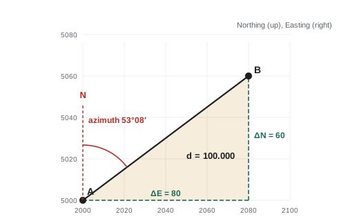
Modern layout uses coordinates. Each point has a northing (N), its distance north of an origin, and an easting (E), its distance east, plus an elevation. Survey instruments such as total stations and GNSS receivers work directly in coordinates, and building grids are often defined by the coordinates of their intersections. The differences in northing and easting between two points, called latitude and departure, form the legs of a right triangle, so Pythagoras gives the distance and trigonometry gives the direction.
An azimuth is a direction measured clockwise from north, from 0° to 360°. A bearing is the angle from north or south towards east or west, such as N 53°08' E. When using tan⁻¹, check the quadrant from the signs of ΔN and ΔE: if ΔN is negative, add 180°; if ΔN is positive and ΔE negative, add 360°. Many calculators and spreadsheets provide an ATAN2 function that handles the quadrants automatically.
Worked problem
Distance and direction between control points
Control point A has coordinates N 5,000.000, E 2,000.000 and point B has N 5,060.000, E 2,080.000 (units are those of the project, metres or feet). (a) What is the horizontal distance AB? (b) What is the azimuth and bearing from A to B? (c) What is the azimuth from B back to A?
Show solution
- (a) ΔN = 60.000; ΔE = 80.000; d = √(60² + 80²) = √10,000 = 100.000 units (a 3-4-5 triangle scaled by 20).
- (b) Azimuth = tan⁻¹(80 ÷ 60) = 53.130° = 53°07'48", which as a bearing is N 53°07'48" E.
- (c) The back azimuth differs by 180°: 53.130° + 180° = 233.130°, a bearing of S 53°07'48" W.
Answer: 100.000 units at an azimuth of 53°07'48" (N 53°07'48" E); back azimuth 233°07'48".
Areas from coordinates
The area of any polygon can be calculated from the coordinates of its corners, listed in order around the boundary. The coordinate method, often called the shoelace formula because of the criss-cross pattern of the multiplication, multiplies each easting by the next northing and each northing by the next easting, takes the difference of the two sums and halves it. It works for any shape whose sides are straight, however irregular, and is how survey software computes lot and site areas.
Worked problem
Area of a site from its corner coordinates
A site has corners at (E, N) = (0, 0), (40, 0), (46, 30) and (5, 28), in metres, listed in order. Find its area in square metres and square feet.
Show solution
- Products for each side, Eᵢ Nᵢ₊₁ − Eᵢ₊₁ Nᵢ: (0)(0) − (40)(0) = 0; (40)(30) − (46)(0) = 1,200; (46)(28) − (5)(30) = 1,288 − 150 = 1,138; (5)(0) − (0)(28) = 0.
- Sum = 0 + 1,200 + 1,138 + 0 = 2,338.
- Area = 2,338 ÷ 2 = 1,169 m².
- In square feet: 1,169 × 10.7639 = 12,583 ft².
- Check: the site is roughly a 43 m × 29 m quadrilateral, about 1,250 m² if it were a rectangle; 1,169 m² is reasonable for a shape that tapers.
Answer: 1,169 m² (about 12,580 ft²).
Instruments and checks
Total stations measure horizontal and vertical angles and distances and compute coordinates; GNSS receivers compute positions from satellite signals, with real-time corrections that give centimetre-level accuracy; laser levels project level or sloping planes for interior and slab work; and machine control systems guide excavators and graders directly from a design surface. These tools do the arithmetic automatically, but they still depend on correct control points, correct design files and correct units. A check measurement by an independent method, such as taping a diagonal or levelling to a benchmark, remains essential.
Common mistakes
MistakeAdding a foresight or subtracting a backsight.
InsteadBS is added to get HI; FS is subtracted from HI.
MistakeAccepting a level run without closing on a benchmark.
InsteadClose the run back on a known point and compare the misclosure with the allowable value.
MistakeReversing cut and fill.
InsteadDesign minus existing: negative is cut, positive is fill.
MistakeMixing chainage in metres with stations of 100 ft.
InsteadCheck the station format on the drawing before calculating distances.
MistakeTaking tan⁻¹ without checking the quadrant.
InsteadUse the signs of ΔN and ΔE or the ATAN2 function.
Summary and key terms
- Elevations are heights above a datum, carried from benchmarks.
- HI = benchmark elevation + backsight; elevation = HI − foresight.
- ΣBS − ΣFS = last − first checks arithmetic; closing on a benchmark checks readings.
- Cut or fill = design elevation − existing elevation.
- Stations or chainage locate points along a line; offsets locate points beside it.
- Distance and azimuth follow from coordinate differences by Pythagoras and tan⁻¹.
- The coordinate (shoelace) method gives the area of any straight-sided polygon.
- Benchmark
- Stable point of known elevation.
- Backsight
- Rod reading on a point of known elevation.
- Foresight
- Rod reading on a point whose elevation is wanted.
- Height of instrument
- Elevation of the level line of sight.
- Turning point
- Temporary point used to move the level.
- Grade stake
- Stake marked with cut or fill to design grade.
- Station
- Distance along a baseline or centre line.
- Batter board
- Board outside the excavation carrying layout strings.
- Northing and easting
- Coordinates north and east of an origin.
- Azimuth
- Direction measured clockwise from north.
Practice problems
Work each problem on paper first, then reveal the answer to check.
BM = 50.000, BS = 1.200. What is HI?
Show answer
51.200.
HI = 51.200, FS = 2.450. Elevation?
Show answer
48.750.
ΣBS = 4.215, ΣFS = 5.020, start 100.000. Final elevation?
Show answer
99.195.
Existing 45.80, design 46.25. Cut or fill?
Show answer
Fill 0.45.
Distance between chainages 0+420.000 and 0+735.250?
Show answer
315.250 m.
Distance between stations 3+75.00 and 9+20.50?
Show answer
545.50 ft.
A pipe at 1 % runs between those stations. Fall?
Show answer
5.46 ft.
ΔN = −30, ΔE = 40. Distance and azimuth?
Show answer
50; 180° − 53.13° = 126.87°.
Area of the triangle (0,0), (20,0), (0,15)?
Show answer
150 square units.
String at 25.300, footing bottom at 23.150. Depth below string?
Show answer
2.150.
Lesson quiz · 5 questions
Score 60% or more to complete this lesson.
Create a free account to save your progress, take quizzes and earn a certificate.