
PHOT-350 · Lesson 9 of 12 · 31 min
Specialized imaging: thermal, multispectral and inspection
Many paying drone jobs are not about beautiful pictures at all. A roofer needs to see damaged shingles without climbing; a solar farm owner needs to find failing panels among tens of thousands; a farmer wants to know which part of a field is stressed before the eye can see it; a utility needs close-ups of insulators on a tower. These jobs use the same flying and planning skills as aerial photography, but with different sensors and different questions. This lesson introduces thermal imaging, multispectral imaging for vegetation, visual inspection of roofs and structures, and the role of drones in public safety and search and rescue. It focuses on what each sensor measures, how to plan for useful data and where specialized training or certification is needed.
Seeing heat: thermal imaging basics
Every object emits infrared radiation according to its temperature. Thermal cameras detect long-wave infrared, roughly 7.5 to 14 micrometers in wavelength, and display differences in apparent temperature as an image. Drone thermal cameras usually use uncooled microbolometer sensors with modest resolution, commonly 640 × 512 pixels, compared with tens of megapixels for visible cameras. Many are paired with a visible camera in the same housing so operators can compare the two views.
A thermal image does not show temperature directly; it shows the radiation reaching the sensor. That radiation depends on the surface's emissivity, its ability to emit infrared. Matte surfaces such as roofing membrane, painted walls, skin and vegetation have high emissivity, around 0.9 to 0.98, and read close to their true temperature. Shiny metals have low emissivity and reflect the infrared of their surroundings, including the sky, so a polished metal roof can look cold even when it is hot. Radiometric cameras record a temperature value for every pixel and let the analyst set emissivity, reflected temperature and distance later; non-radiometric cameras only show relative differences.
For thermal cameras, it is often easier to compute GSD from the sensor's pixel pitch p (the size of one pixel on the sensor) rather than the sensor width.
Worked problem
How fine is the thermal detail?
A drone thermal camera has 12 µm pixels and a 13.5 mm lens. A solar inspection is flown at 40 m. What is the thermal GSD, and how many pixels cover a single solar cell about 16 cm wide?
Show solution
- GSD = 0.000012 × 40 ÷ 0.0135.
- GSD ≈ 0.0356 m ≈ 3.6 cm per pixel.
- Cells: 16 ÷ 3.6 ≈ 4.5 pixels across.
Answer: About 3.6 cm per pixel, so each cell spans about 4 to 5 pixels, enough to locate a hot cell but not to see fine detail. Flying lower improves detail.
Thermal applications and conditions
Thermal drones are used for solar panel inspection (finding hot cells, failed bypass diodes and disconnected strings), roof moisture surveys (wet insulation holds heat after sunset and shows as warm patches on flat roofs), building envelope inspections (heat loss, missing insulation, air leaks), electrical inspections of substations and lines, search and rescue at night, wildlife counts, and firefighting support to find hotspots through smoke.
Conditions decide whether thermal data is useful. Building heat-loss surveys need a large temperature difference between inside and outside, commonly at least 10 °C, which in Canada and the northern US means cool or cold weather; they are best done before sunrise, without wind or recent sun on the walls, and with dry surfaces. Roof moisture surveys are flown in the hours after sunset on a clear day following a sunny day, so dry areas cool quickly while wet areas stay warm. Solar inspections need strong sunlight on the panels, commonly at least about 600 W/m² of irradiance, so that faults heat up, with the camera angle chosen to avoid reflections of the sun or sky.
| Application | Best conditions | What a fault looks like |
|---|---|---|
| Solar panels | Clear sky, strong sun on panels, low wind | Hot cell, hot module, hot string or diode pattern |
| Flat roof moisture | Evening after a sunny day, dry clear night | Warm patches where insulation is wet |
| Building heat loss | Before sunrise, inside 10 °C+ warmer, calm, dry | Warm streaks at joints, windows and missing insulation |
| Electrical equipment | Under load, low reflected sun | Hot connections and components compared with similar parts |
| Search and rescue | Night or cool conditions, open terrain | A warm human-shaped target against cool ground |
Interpreting thermal images takes training. Reflections, wind, sun-warmed surfaces, shadows from clouds and differences in emissivity can all look like defects. Professional thermographers take certification courses at Level 1, 2 or 3 from recognized training bodies, follow standards for building and electrical thermography, and write reports that state conditions, settings and limits. Photographers entering thermal work usually partner with, or train as, certified thermographers, and describe their reports carefully as findings to be confirmed rather than final diagnoses.
In the United States, building thermography commonly follows ASTM standards such as ASTM C1060 for insulation in frame buildings and ASTM C1153 for roof moisture, and many inspectors hold Level 1 or higher certification. Electrical work near energized equipment falls under OSHA rules and NFPA 70E.
Multispectral imaging and vegetation
Healthy plants absorb much of the red light that falls on them, using it for photosynthesis, and strongly reflect near-infrared (NIR) light, which their leaf structure scatters. Stressed, diseased or dying plants reflect more red and less NIR. Multispectral cameras capture separate narrow bands, typically blue, green, red, red edge and near-infrared, and a sunlight sensor on top of the drone records changing light so values can be calibrated across a flight.
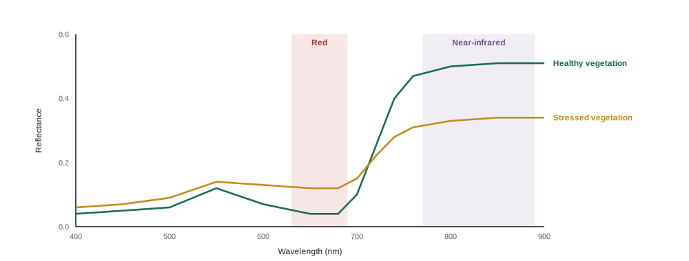
The most widely used vegetation index is the normalized difference vegetation index (NDVI), calculated pixel by pixel from the red and NIR reflectance. Values range from −1 to +1: dense, healthy vegetation typically scores above about 0.6, bare soil around 0.1 to 0.2, and water near zero or below.
Worked problem
Comparing two parts of a field
In zone A of a canola field, the calibrated reflectance is 0.48 in NIR and 0.06 in red. In zone B, it is 0.32 in NIR and 0.12 in red. Calculate NDVI for each and interpret.
Show solution
- Zone A: (0.48 − 0.06) ÷ (0.48 + 0.06) = 0.42 ÷ 0.54 ≈ 0.78.
- Zone B: (0.32 − 0.12) ÷ (0.32 + 0.12) = 0.20 ÷ 0.44 ≈ 0.45.
- Zone B is markedly lower.
Answer: Zone A ≈ 0.78 (vigorous); zone B ≈ 0.45 (thinner or stressed). Zone B needs a visit on the ground to find out why: drainage, pests, nutrients or seeding problems.
Other indices, such as NDRE, which uses the red edge band, are more sensitive in dense crops where NDVI saturates. Multispectral data is processed with photogrammetry software into calibrated index maps, which agronomists use to plan scouting and variable-rate fertilizer or spraying. Consistent conditions, ideally near midday under steady sun or uniform overcast, and calibration with a reflectance panel before and after each flight make maps comparable over time.
Drones can also spray crops, but spraying is regulated separately and heavily, because of pesticide laws and the weight of loaded spray drones. Aerial photographers working in agriculture should understand that mapping and spraying are very different operations.
Visual inspection of roofs and structures
Inspection is one of the largest commercial uses of drones. A drone can photograph a roof, chimney, cell tower, bridge, wind turbine or building facade in detail without scaffolding or rope access, reducing both cost and the risk of falls. Typical inspection deliverables are sets of geotagged close-up photos, annotated images of defects, short videos, and sometimes 3-D models or orthomosaics.
Good inspection imaging is systematic. The pilot plans a pattern that covers every surface, for example orbiting a tower at several heights, or flying a facade in vertical strips, with enough overlap that no area is missed and the location of each defect can be traced. Zoom cameras let the drone keep a safe distance from structures and energized equipment while still resolving small defects such as cracked welds, missing bolts or damaged shingles.
Worked problem
Keeping distance with a zoom lens
An inspector needs about 1 mm per pixel on a tower's bolts. A zoom camera has a pixel pitch of 3.3 µm. At a focal length of 50 mm, how far can the drone stay from the tower?
Show solution
- From GSD = p × d ÷ f, distance d = GSD × f ÷ p.
- d = 0.001 × 0.050 ÷ 0.0000033.
- d ≈ 15 m.
Answer: About 15 m, which keeps the drone clear of guy wires and antennas. Without the zoom, at 4.5 mm focal length, it would need to be about 1.4 m away, which is unsafe.
Structures bring particular hazards. Steel towers and bridges disturb compasses; cell towers and broadcast antennas emit radio energy that can interfere with control links; high-voltage lines create electromagnetic fields and are hard to see. Rope access workers, maintenance crews or traffic may be nearby. Clients often have their own safety requirements, such as permits to work, minimum distances, site inductions and insurance. Experienced inspectors fly manually close to structures, with obstacle sensing as a backup rather than a guarantee.
Inspection reports must be accurate and modest. A drone photographer can document what is visible, but usually is not qualified to judge whether a structure is safe, a roof needs replacement or a weld meets a code. Those judgments belong to engineers, roofers, building inspectors or other qualified professionals, and the report should say so.
Drones in public safety and search and rescue
Police, fire services, search and rescue teams and emergency managers increasingly use drones to search for missing people, map disaster areas, monitor fires and floods, and document collision and crime scenes. Thermal cameras are particularly valuable at night, when a warm person stands out against cool ground. Many volunteer search and rescue groups train members as drone pilots and work under the direction of the police or another lead agency.
For private photographers, the key lessons are what not to do. Flying over or near an emergency scene, wildfire or disaster without authorization is illegal in both countries and can ground firefighting aircraft or disrupt a search. Volunteers who want to help should join a recognized team, train with it and fly only when tasked. When public safety drones are in the air, private drones must stay away.
In the United States, temporary flight restrictions usually cover wildfires and disasters, and flying in them can bring fines and criminal charges; the FAA has repeatedly warned that "if you fly, we can't". Public agencies may fly under Part 107 or a Certificate of Authorization, and SAR volunteers often work through county sheriff's teams or other recognized groups.
Data handling for specialized work
Specialized jobs produce large and sometimes sensitive data sets. Thermal and multispectral data must be stored with their calibration and metadata intact; stripping metadata in editing can make radiometric files useless. Inspection images of critical infrastructure, such as substations, water plants or telecommunications sites, may be confidential under the client's contract or security rules. The photographer should agree in advance who owns the data, how long it is kept, how it is transferred securely and whether it can be used in a portfolio (lesson 11).
Worked problem
Sizing a solar inspection
A 20 MW solar farm covers about 40 hectares. A thermal camera's footprint at the chosen altitude is about 23 m by 18 m. With 30 percent overlap in both directions, roughly how many thermal images are needed?
Show solution
- Effective new area per image: (23 × 0.7) × (18 × 0.7) = 16.1 × 12.6 ≈ 203 m².
- Area: 40 ha = 400,000 m².
- Images ≈ 400,000 ÷ 203 ≈ 1,970.
- Add edges and turns: about 2,200.
Answer: Roughly 2,000 to 2,200 thermal images, likely several batteries and a few hours on site, plus visible images if the client wants them.
Common mistakes
MistakeReading a shiny metal roof's cold appearance as its real temperature.
InsteadRemember low-emissivity surfaces reflect their surroundings and read falsely.
MistakeFlying a building heat-loss survey on a warm sunny afternoon.
InsteadFly before sunrise with a large inside-outside temperature difference and no sun on the walls.
MistakeComparing NDVI maps from different days without calibration.
InsteadUse the sunlight sensor and a reflectance panel so values are comparable.
MistakeFlying close to a tower without a zoom lens to get detail.
InsteadUse a zoom camera to keep safe distance from structures and antennas.
MistakeWriting inspection reports that declare a structure safe.
InsteadReport what is visible and refer judgments to qualified professionals.
Summary and key terms
- Thermal cameras detect long-wave infrared; emissivity and reflections affect apparent temperature.
- Radiometric thermal data allows temperatures to be measured and corrected after the flight.
- Thermal work depends on conditions: temperature difference, sun, wind and time of day.
- NDVI = (NIR − Red) ÷ (NIR + Red) highlights plant vigor and stress.
- Multispectral data needs calibration for comparable maps.
- Inspection uses systematic patterns and zoom cameras to keep safe distances.
- Public safety drone work belongs to trained teams; private drones must stay away from emergencies.
Practice problems
Work each problem on paper first, then reveal the answer to check.
Why do shiny metal surfaces give misleading thermal readings?
Show answer
They have low emissivity and reflect the temperature of their surroundings.
A thermal camera has 17 µm pixels and a 13 mm lens at 30 m. What is the GSD?
Show answer
0.000017 × 30 ÷ 0.013 ≈ 3.9 cm.
When is a flat roof moisture survey usually flown?
Show answer
After sunset following a sunny day, on a dry clear night.
Calculate NDVI with NIR 0.40 and red 0.08.
Show answer
0.32 ÷ 0.48 ≈ 0.67.
What does a low NDVI over a crop suggest?
Show answer
Thin, stressed or damaged vegetation, to be checked on the ground.
Why is a reflectance panel used in multispectral surveys?
Show answer
To calibrate reflectance so maps from different flights are comparable.
A zoom camera with 2.4 µm pixels at 100 mm must resolve 2 mm. How far away can it be?
Show answer
0.002 × 0.1 ÷ 0.0000024 ≈ 83 m.
Name two hazards specific to tower inspections.
Show answer
Compass interference from steel, radio interference from antennas, guy wires.
Why must private drones stay away from wildfires?
Show answer
They can ground firefighting aircraft and it is illegal.
Why should inspection reports avoid declaring structures safe?
Show answer
That judgment requires qualified engineers or inspectors.
Lesson quiz · 5 questions
Score 60% or more to complete this lesson.
Create a free account to save your progress, take quizzes and earn a certificate.