
PET-210 · Lesson 12 of 12 · 19 min
The Permian Basin and the Gulf of Mexico
At the end of the term, Nadia asks Ethan to present the screening study to Prairie Crest's managers: two very different basins, the Permian Basin of West Texas and southeastern New Mexico and the Gulf of Mexico, seen whole, with every idea from the course in its place. Together they produce more than half of the oil in the United States. The Permian is an old, layered, faulted basin full of carbonates and organic-rich shales, now drilled mostly with horizontal wells; the Gulf of Mexico is a young passive margin full of sand and salt, much of it explored in deep water. Comparing them shows how the same principles of source, reservoir, seal, trap and timing play out in different settings.
The Permian Basin: structure and history
The Permian Basin covers roughly 220,000 square kilometers (about 86,000 square miles). It began as part of a broad, slowly subsiding Paleozoic basin, the Tobosa Basin. In the Late Mississippian and Pennsylvanian, collision between North America and South America-Africa during the assembly of Pangaea broke it along reactivated basement faults into deep sub-basins separated by uplifted blocks: the Delaware Basin to the west, the Midland Basin to the east, and the Central Basin Platform between them. During the Permian, the deep basins filled with fine-grained sediment and organic-rich mud while warm, shallow seas built reefs and carbonate shelves around their margins. At the end of the Permian, the basins became restricted and filled with thick evaporites, including salt and anhydrite, which seal the system.
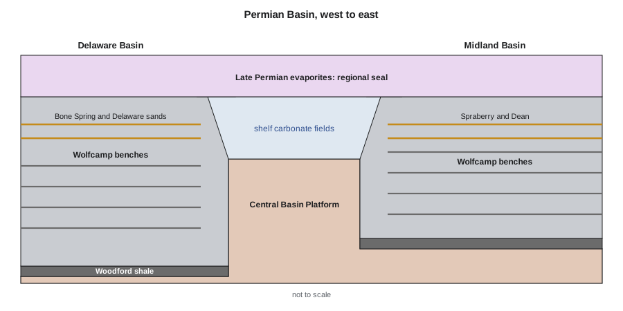
This architecture of shelf, reef rim and deep basin, capped by evaporites, created many petroleum systems. The Devonian Woodford shale and Permian Wolfcamp and Leonardian shales are major source rocks. Their oil charged conventional reservoirs in shelf carbonates, reefs and basin-floor sands, and much of it stayed in the source rocks and the tight sandstones and carbonates interbedded with them.
Permian plays: conventional and unconventional
| Play | Setting | Reservoir | Trap or style |
|---|---|---|---|
| Central Basin Platform carbonates | Uplifted platform between the sub-basins | San Andres, Grayburg and older dolomites | Anticlines and stratigraphic porosity traps |
| Capitan reef margin | Rim of the Delaware Basin | Reef and fore-reef carbonates | Combination traps along the reef trend |
| Delaware Mountain Group | Deep Delaware Basin | Basin-floor sandstones (Bell Canyon, Cherry Canyon, Brushy Canyon) | Stratigraphic channels and lobes |
| Wolfcamp | Delaware and Midland basins | Stacked organic-rich mudstones, siltstones and carbonates | Continuous accumulation drilled with horizontal wells |
| Spraberry and Dean | Midland Basin | Tight siltstones and fine sandstones | Continuous accumulation; formerly vertical waterfloods |
| Bone Spring | Delaware Basin | Interbedded tight sandstones and carbonates | Continuous accumulation drilled with horizontal wells |
For most of the twentieth century, the Permian was a conventional province. Giant fields such as Yates, discovered in 1926 on the eastern edge of the Central Basin Platform, and Wasson produced from porous dolomites on the shelves, and carbon dioxide flooding was pioneered there from the 1970s, using carbon dioxide piped from natural underground sources. From about 2010, horizontal drilling and multistage fracturing turned the basin's source rocks and tight rocks into the largest oil-producing region in the country. In 2026 the Permian supplies about half of United States crude oil production, which the Energy Information Administration expects to average a record of about 13.8 million barrels per day for the year.
The Permian's tight-oil plays are stacked: in places, wells target more than half a dozen separate benches within a few hundred meters of section, from the Bone Spring and Spraberry down through several Wolfcamp benches. Mapping the thickness, organic content, maturity, pressure and brittleness of each bench, the methods of Lessons 5, 9 and 10, decides where and at what depth to land wells. Rising gas and water production as the basin matures, the disposal of large volumes of produced water, and induced seismicity linked to that disposal are now major engineering and regulatory challenges.
The Gulf of Mexico: a passive margin full of salt
The Gulf of Mexico opened in the Jurassic as North America separated from South America and Africa. Early in its history, seawater flooded the young rift repeatedly and evaporated, depositing a thick layer of salt, the Louann salt. Since then, the Mississippi and other rivers have poured sediment into the basin, building deltas and pushing the shoreline far out into the Gulf; more than 10 kilometers of sediment have accumulated in places. Loaded by this sediment, the salt has flowed upward and seaward into domes, walls and vast sheets, some of which now lie near the sea floor above younger sediments.
Salt movement created most of the Gulf's traps, as Lesson 7 described: anticlines over salt pillows, traps against the flanks of domes, faulted traps above them, and traps beneath salt sheets. The main reservoirs are Cenozoic sandstones deposited by deltas on the shelf and by turbidity currents in deep water, and the main source rocks are Jurassic and younger marine shales. Onshore and on the shelf, exploration began with Spindletop in 1901 and continued with thousands of salt-dome and growth-fault fields. In deep water, from the 1980s onward, three-dimensional seismic and the recognition of turbidite reservoirs beneath and beside salt led to giant discoveries, including fields in the Paleogene Wilcox trend at depths of more than 7,000 meters below sea level.
Federal offshore production in the Gulf of Mexico is close to 2 million barrels of oil per day, most of it from deepwater fields served by floating production facilities. Deepwater wells are among the most expensive in the world, so exploration there relies heavily on seismic amplitude and AVO analysis, discussed in Lesson 10, to reduce the risk of finding gas or poor sands, and on careful pressure prediction, because rapid burial of muds creates strong overpressure.
# Oil in place per section (640 acres) for stacked Permian benches and a deepwater Gulf of Mexico sand
ACRES = 640
def ooip(h_ft, phi, so, bo):           # stock-tank barrels
    return 7758 * ACRES * h_ft * phi * so / bo
benches = {                            # (net ft, porosity, oil saturation, Bo, recovery factor)
    'Spraberry':       (200, 0.07, 0.70, 1.6, 0.10),
    'Wolfcamp A':      (300, 0.06, 0.65, 1.6, 0.10),
    'Wolfcamp B':      (250, 0.05, 0.60, 1.6, 0.08),
}
tot = rec = 0
print(f"{'interval':22s}{'OOIP, MMSTB':>13s}{'recoverable, MMSTB':>21s}")
for name, (h, phi, so, bo, rf) in benches.items():
    n = ooip(h, phi, so, bo); tot += n; rec += n * rf
    print(f"{name:22s}{n / 1e6:13.1f}{n * rf / 1e6:21.1f}")
print(f"{'Permian stack total':22s}{tot / 1e6:13.1f}{rec / 1e6:21.1f}")
n = ooip(120, 0.25, 0.80, 1.3)          # one thick, porous deepwater turbidite sand
print(f"{'Gulf deepwater sand':22s}{n / 1e6:13.1f}{n * 0.35 / 1e6:21.1f}")
print(f"deepwater sand holds {n / tot:.1f} times the Permian stack per section")interval OOIP, MMSTB recoverable, MMSTB Spraberry 30.4 3.0 Wolfcamp A 36.3 3.6 Wolfcamp B 23.3 1.9 Permian stack total 90.0 8.5 Gulf deepwater sand 91.7 32.1 deepwater sand holds 1.0 times the Permian stack per section
The program compares oil in place per square mile, a section, for several stacked Permian benches and for a single deepwater Gulf of Mexico sand. Each Permian bench holds a moderate amount, but stacking three makes a section rich. A single thick, porous deepwater sand holds about as much as the whole stack and, because it flows far more easily, recovers three to four times as much oil, but it costs far more to reach. The comparison illustrates why the two basins attract very different kinds of companies and technologies.
Worked problem
Screening a stacked Permian section
Ethan screens a Midland Basin section with three target benches: an upper bench 200 ft thick with 7 percent porosity and 70 percent oil saturation, a middle bench 300 ft thick with 6 percent and 65 percent, and a lower bench 250 ft thick with 5 percent and 60 percent. Use B_o = 1.6 reservoir bbl/STB. Estimate oil in place per section (640 acres) for each bench and the total.
Show solution
- N = 7758 A h φ S_o / B_o, with A = 640 acres.
- Upper: 7758 × 640 × 200 × 0.07 × 0.70 / 1.6 = 30.4 million STB.
- Middle: 7758 × 640 × 300 × 0.06 × 0.65 / 1.6 = 36.3 million STB.
- Lower: 7758 × 640 × 250 × 0.05 × 0.60 / 1.6 = 23.3 million STB.
- Total: about 90 million STB per section.
Answer: About 90 million stock tank barrels in place per section. With horizontal wells recovering perhaps 8 to 12 percent, a section might yield 7 to 11 million barrels, which is why acreage in the core of the basin is so valuable.
Outcrop analogues and the older Gulf systems
The Permian Basin has one of the finest outcrop analogues in the world. In the Guadalupe Mountains of West Texas and New Mexico, uplift and erosion have exposed the Capitan reef and the shelf and basin rocks on either side of it in cliffs hundreds of meters high. Geologists walk from lagoonal shelf carbonates across the reef into steep fore-reef debris and down to the thin basinal sandstones and siltstones of the Delaware Basin, seeing in a single day the geometry they must map from wells and seismic in the subsurface. Much of modern sequence stratigraphy of carbonate platforms was developed and tested on these exposures, and the nearby Carlsbad Caverns are dissolution caves in the same reef.
In the Gulf of Mexico, the oldest plays lie beneath the young deltas. The Jurassic Smackover limestone, deposited on ramps around the edge of the new basin, produces oil and gas from oolitic grainstones in a belt from East Texas through Arkansas, Louisiana, Mississippi and Alabama, and the Smackover brines are now explored for lithium. The Jurassic Norphlet sandstone, wind-blown dunes deposited just after the salt, forms deep gas reservoirs offshore Alabama and deepwater oil fields in the eastern Gulf. The Late Jurassic Haynesville shale in East Texas and northwestern Louisiana, a major source rock, is drilled with horizontal wells for gas, much of which now supplies liquefied natural gas export terminals on the Gulf Coast.
Ethan adds one practical comparison for the managers. A Permian horizontal well is typically drilled in a couple of weeks and costs millions of dollars, and hundreds are drilled each year, so results arrive quickly and the program can be adjusted as it goes. A deepwater Gulf of Mexico well can take months, cost more than a hundred million dollars, and depend on a production platform that takes years to build. The geology sets the size of the prize in each basin, but the pace and scale of the engineering decide which companies can pursue it, and that is the question Prairie Crest must answer for itself.
Comparing the basins and closing the study
The two basins illustrate the range of petroleum geology. The Permian is an old basin whose systems were set up by Paleozoic tectonics and sealed by Permian evaporites, and whose greatest remaining resource is in its source rocks and tight rocks. The Gulf of Mexico is a young basin still actively subsiding and filling, whose systems are shaped by salt and whose richest reservoirs are thick, porous turbidite sands far offshore. Both show how understanding the petroleum system, its source, reservoir, seal, trap and timing, guides where to look and how to produce.
For Prairie Crest, the screening ends with a recommendation: its Bakken acreage remains the core of the business, the conventional anticline Nadia found is worth a risked well, and a small, non-operated position in the Midland Basin would add stacked tight-oil inventory at manageable cost, while the deepwater Gulf of Mexico is beyond the company's scale. Ethan presents the volumes as ranges and the chances of success honestly, and Lena's economic model ranks them. The geology does not make the decisions, but it frames them, which is the role of a petroleum geologist in any company.
Common mistakes
MistakeTreating the Permian as one uniform play.
InsteadIt contains sub-basins, platforms and many stacked benches with different properties.
MistakeAssuming salt traps are simple domes.
InsteadSalt forms pillows, walls and sheets that create many trap types and complicate imaging.
MistakeComparing basins by in-place volume alone.
InsteadRecovery factors, depth, water depth and costs differ enormously.
MistakeIgnoring produced water and induced seismicity in mature tight-oil basins.
InsteadWater handling and disposal are major constraints on Permian development.
Summary and key terms
- The Permian Basin was broken into the Delaware and Midland basins and the Central Basin Platform by late Paleozoic tectonics and sealed by Permian evaporites.
- Its shelf carbonates and reefs held giant conventional fields; its Wolfcamp, Spraberry and Bone Spring benches are now drilled with horizontal wells.
- In 2026 the Permian supplies about half of a record United States crude output of roughly 13.8 million barrels per day.
- The Gulf of Mexico is a Jurassic passive margin whose Louann salt has flowed into domes, walls and sheets that create most traps.
- Deepwater turbidite sands beneath and beside salt hold giant fields; seismic amplitudes, AVO and pressure prediction are essential.
- Comparing basins means comparing volumes, recovery, depth and cost, not just resources in place.
- Permian Basin
- A Paleozoic basin in West Texas and southeastern New Mexico, the largest oil-producing region in the United States.
- Central Basin Platform
- An uplifted block separating the Delaware and Midland basins.
- Capitan reef
- A Permian reef rimming the Delaware Basin, exposed in the Guadalupe Mountains.
- Wolfcamp
- A stacked sequence of organic-rich Permian mudstones and tight rocks, a major tight-oil target.
- Louann salt
- A thick Jurassic salt layer beneath the Gulf of Mexico that has flowed to form many traps.
- Turbidite reservoir
- A sandstone deposited by turbidity currents in deep water.
- Allochthonous salt
- Salt that has flowed sideways far from its original layer, often forming sheets.
Practice problems
Work each problem on paper first, then reveal the answer to check.
What tectonic event broke the ancestral Permian basin into sub-basins and platforms?
Show answer
Late Paleozoic collision during the assembly of Pangaea, which reactivated basement faults.
Why are Permian evaporites important to the petroleum system?
Show answer
They form a regional seal over the basin's reservoirs.
Explain how salt movement creates traps in the Gulf of Mexico.
Show answer
Rising and flowing salt forms domes, pillows and sheets that fold, fault and seal the surrounding sands.
Using N = 7758 A h φ S_o / B_o, estimate oil in place for 640 acres, 100 ft, 8 percent porosity, 70 percent oil saturation and B_o = 1.5.
Show answer
7758 × 640 × 100 × 0.08 × 0.70 / 1.5 = 18.5 million STB.
Lesson quiz · 5 questions
Score 60% or more to complete this lesson.
Create a free account to save your progress, take quizzes and earn a certificate.