
PET-210 · Lesson 7 of 12 · 19 min
Structural traps
Nadia has found a lead. On a seismic line licensed from an older survey, the Red River and Madison reflections rise into a gentle anticline above a deep basement fault about thirty kilometers from Prairie Crest's Bakken acreage. 'If that fold is real, and if it closes on all sides, it could hold conventional oil below and above the Bakken,' she says. 'Our first job is to prove it closes. A fold that leaks out one end is just a bump.' Structural traps, formed when rocks are folded, faulted or pushed up by salt, hold most of the world's discovered conventional oil and gas, including the great salt-related fields of the Gulf of Mexico. This lesson explains how they form, how geologists describe them, and how engineers estimate how much they can hold.
Stress, strain and deformation
Rocks deform when tectonic forces act on them. Geologists describe the forces as stress, force per unit area, which has three principal components at right angles: the largest, intermediate and smallest principal stresses. Near the surface, rocks are brittle and break along faults and fractures. Deeper, at higher temperature and confining pressure, they become more ductile and fold. The same layer can fold in one place and fault in another depending on its strength, thickness and the rate of deformation. Shale and salt are weak and flow easily; sandstone and limestone are stronger and tend to break.
The type of deformation reflects the tectonic setting. Compression, where plates converge, shortens the crust, folds rocks and pushes older rocks up over younger ones along thrust faults. Extension, where the crust stretches, creates normal faults and tilted blocks. Strike-slip, where blocks slide past each other horizontally, produces faults with complex bends and associated folds. Salt and shale can move in any setting, driven by their low density and weakness. Each regime produces characteristic trap styles.
Anticlines and domes
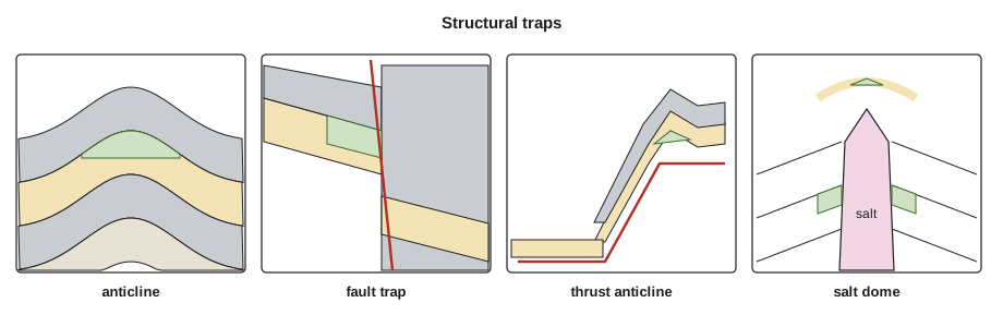
An anticline is an arch-shaped fold in which the rock layers dip away from a central line, the axis. When an anticline plunges at both ends and closes in all directions, it forms a dome, an ideal trap: oil rising through a reservoir layer collects at the crest, held in place by a seal above. Anticlines were the first traps the industry learned to find, beginning with the anticlinal theory of the 1860s, and they remain among the easiest to image on seismic data and to map from wells.
Folds form in several ways. Buckle folds form when layers are squeezed from the side. Fault-related folds form above thrust faults: fault-bend folds where a thrust climbs over a ramp, and fault-propagation folds at the tip of a growing thrust. Drape folds form where sediments settle over a buried high, such as a fault block or a reef, and compaction exaggerates the relief. Each mechanism predicts a different shape and fracture pattern, which affects the reservoir's performance as well as its volume.
Fault traps
A fault is a fracture along which the rocks on either side have moved. Normal faults form under extension, with the hanging wall, the block above the fault plane, moving down. Reverse and thrust faults form under compression, with the hanging wall moving up; a thrust is a low-angle reverse fault. Strike-slip faults move sideways. A fault trap forms where a fault places a reservoir layer against an impermeable rock, or where the fault zone itself seals, so that oil rising up the reservoir is stopped at the fault. Most fault traps also rely on dip or folding on the other sides.
Whether a fault seals is often the main risk in a fault trap, as Lesson 6 explained. Juxtaposition diagrams show which layers face each other; shale gouge ratio predicts whether sand-on-sand contacts will seal. Faults can also be conduits: an active fault may let oil escape upward, while a fault that later becomes cemented may seal. The timing of fault movement relative to migration therefore matters as much as the fault's present geometry.
Rift basins and passive margins are full of fault traps. In the North Sea, tilted fault blocks of Jurassic sandstone, sealed by Cretaceous shale draped across their eroded crests, hold giant fields such as Brent. In deltas such as the Mississippi and Niger, growth faults, normal faults that moved while sediment was being deposited, thicken sand layers on their downthrown sides, and the beds roll over into the fault to form anticlinal traps called rollover anticlines.
Thrust belt traps
The fold-and-thrust belts of the Rocky Mountains host many structural traps. In the Wyoming-Utah thrust belt, discovered in the 1970s, sheets of Paleozoic and Mesozoic rock were pushed eastward and folded above thrust faults, trapping oil and gas in fields such as Painter Reservoir and Whitney Canyon. Thrust traps are hard to image on seismic data because steep, faulted layers scatter sound, so wells sometimes miss the crest even after careful mapping. In the Williston Basin, by contrast, structures are mostly gentle folds above reactivated basement faults, such as the Nesson and Cedar Creek anticlines, which trap oil in Madison, Red River and other carbonates.
Salt-related traps
Salt behaves like a very viscous fluid over geological time. It is less dense than most buried sediment, so it rises buoyantly, and it flows away from heavy loads of overlying sediment. As it moves, it forms pillows, domes, walls and sheets, and in places it breaks through the overlying layers entirely. The movement creates many kinds of traps: anticlines over the crests of salt pillows, traps against the flanks of piercing salt domes where upturned sandstones are sealed by the impermeable salt, faulted traps above the domes where the overlying rocks were stretched, and traps beneath overhanging salt sheets.
The Gulf of Mexico is the world's type example. Spindletop, near Beaumont, Texas, where a gusher blew out on 10 January 1901, was a salt dome. Today, many of the largest deepwater discoveries lie beneath or beside allochthonous salt sheets, bodies of salt that have flowed sideways for tens of kilometers. Salt also creates difficulties: it distorts seismic images because sound travels through it much faster than through surrounding sediment, it creeps into boreholes, and it can cause sharp changes in pressure and temperature.
Fractures and stress in folded reservoirs
Folding and faulting do more than create closure; they also fracture the reservoir. Where a stiff layer bends over the crest of an anticline, its outer arc is stretched and cracks open parallel to the fold axis, while the inner arc is compressed. Near faults, the rock is broken into a damage zone of small faults and fractures. These natural fractures can turn a tight carbonate or sandstone into a productive reservoir, as in many fields of the Zagros fold belt of Iran and Iraq, where fractured limestone anticlines produce at very high rates. They can also cause trouble: water may race along a fracture swarm from the aquifer to a producing well, and drilling fluids may be lost into open fractures.
The present-day stress field matters too. The direction of the maximum horizontal stress controls which natural fractures stay open and which are squeezed shut, and it sets the direction in which hydraulic fractures grow. Geologists measure stress orientation from borehole breakouts, the elongation of a well where the wall spalls in the direction of the minimum stress, and from drilling-induced fractures on image logs. Engineers use the results to orient horizontal wells across the main fracture direction, so that each well intersects as many fractures as possible.
Describing and measuring a structural trap
Geologists map a trap with a structure contour map, which shows the depth of the top of the reservoir with lines of equal depth, as a topographic map shows elevation. The crest is the shallowest point. The spill point is the deepest point at which the closed contours still close; any oil added below it will spill out of the trap along the lowest saddle. The vertical distance from the crest to the spill point is the structural closure, and the area inside the spill contour is the closed area. A trap that is full to spill holds the maximum volume its geometry allows; many traps are underfilled because the seal leaks, the charge was limited, or the trap formed after most migration.
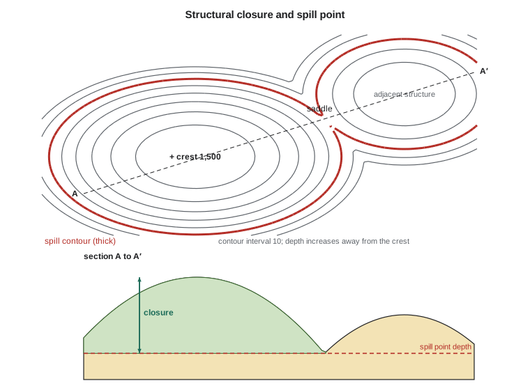
The gross rock volume of a trap, the volume of reservoir rock above the oil-water contact or spill point, is found by measuring the area enclosed by each contour, plotting area against depth, and integrating. The trapezoidal rule works for gentle structures; for domes, the pyramidal rule, which assumes each slice is a frustum of a pyramid, is more accurate. Multiplying the gross rock volume by net-to-gross, porosity and hydrocarbon saturation, as in Lesson 3, gives the hydrocarbon pore volume. When the reservoir is thinner than the closure, the volume between the top and base of the reservoir must be calculated separately, a correction for the geometry of thin beds on structures.
# Gross rock volume of an anticline above an oil-water contact from contour areas
import math
# (depth of top reservoir contour in ft, area enclosed in acres), crest at 8,660 ft
contours = [(8660, 0), (8700, 240), (8740, 650), (8780, 1190), (8820, 1820), (8860, 2510), (8900, 3270)]
OWC = 8840.0                                     # base-case oil-water contact, ft

def area_at(z):
    for (z1, a1), (z2, a2) in zip(contours, contours[1:]):
        if z1 <= z <= z2: return a1 + (a2 - a1) * (z - z1) / (z2 - z1)
    raise ValueError(z)

def grv(owc, rule):
    pts = [c for c in contours if c[0] < owc] + [(owc, area_at(owc))]
    v = 0.0
    for (z1, a1), (z2, a2) in zip(pts, pts[1:]):
        h = z2 - z1
        v += h * (a1 + a2) / 2 if rule == "trap" else h / 3 * (a1 + a2 + math.sqrt(a1 * a2))
    return v                                     # acre-ft

t, p = grv(OWC, "trap"), grv(OWC, "pyr")
print(f"trapezoidal  gross rock volume above {OWC:.0f} ft: {t:9,.0f} acre-ft")
print(f"pyramidal    gross rock volume above {OWC:.0f} ft: {p:9,.0f} acre-ft")
print(f"difference: {(t - p) / p:+.1%}")
for owc in (8820, 8840, 8900):
print(f"contact at {owc} ft -> {grv(owc, 'pyr'):9,.0f} acre-ft")trapezoidal gross rock volume above 8840 ft: 159,450 acre-ft pyramidal gross rock volume above 8840 ft: 156,148 acre-ft difference: +2.1% contact at 8820 ft -> 116,348 acre-ft contact at 8840 ft -> 156,148 acre-ft contact at 8900 ft -> 317,845 acre-ft
The program compares the two rules. For a dome, the trapezoidal rule slightly overestimates each slice where the area changes sharply, especially near the crest; the difference is modest overall but grows for steep, narrow structures. More important in practice is uncertainty in the depth conversion of the seismic map and in the position of the contact, which can change the volume by tens of percent.
Worked problem
Full-to-spill or underfilled?
Nadia's mapped anticline has its crest at 8,660 ft and a spill point at 8,900 ft, a closure of 240 ft. A seal study suggests the overlying shale can hold an oil column of about 180 ft, and the oil-water contact in a nearby analog sits 160 ft below its crest. Which column should the team use for the base case?
Show solution
- Structural closure: 240 ft. Seal capacity: about 180 ft. The trap can only be filled to the smaller of the two, so the seal limits the column to about 180 ft.
- The analog column of 160 ft supports a seal-limited case.
- Base case: contact at 8,660 + 180 = 8,840 ft. Low case: 8,820 ft from the analog. High case: full to spill at 8,900 ft.
- The volume is very sensitive to the contact on a gentle structure, because each extra foot adds the largest area.
Answer: A seal-limited base case, with full-to-spill as an upside. Presenting low, base and high cases makes the uncertainty explicit, which Lesson 11 builds into risk and volume estimates.
Common mistakes
MistakeAssuming every fold on a seismic line is a closed trap.
InsteadA trap must close in all directions. Map it in three dimensions and find the spill point.
MistakeAssuming a trap is full to spill.
InsteadSeal capacity, limited charge and late trap formation often leave traps underfilled.
MistakeIgnoring fault timing.
InsteadAn active fault may leak; a fault that formed after migration cannot have trapped that oil.
MistakeTrusting seismic depths without depth conversion uncertainty.
InsteadVelocity errors, especially near salt or steep faults, can move the crest and spill point by tens of meters.
Summary and key terms
- Structural traps form by folding, faulting and salt movement; compression, extension and strike-slip each produce characteristic styles.
- Anticlines and domes trap oil at their crests; fault-related folds, drape folds and rollover anticlines are common variants.
- Fault traps depend on juxtaposition and fault rock sealing, and on fault timing relative to migration.
- Thrust belt traps are productive but hard to image; salt-related traps dominate the Gulf of Mexico.
- Structure contour maps define the crest, spill point, closure and closed area.
- Gross rock volume comes from integrating contour areas with the trapezoidal or pyramidal rule.
- Anticline
- An arch-shaped fold with layers dipping away from its axis.
- Normal fault
- A fault formed by extension in which the hanging wall moves down.
- Thrust fault
- A low-angle reverse fault formed by compression.
- Salt dome
- A body of salt that has risen through overlying layers, creating traps around and above it.
- Spill point
- The deepest point at which a trap still closes; oil added below it escapes.
- Structural closure
- The vertical distance between the crest of a trap and its spill point.
- Gross rock volume
- The volume of reservoir rock above the contact within a trap.
Practice problems
Work each problem on paper first, then reveal the answer to check.
A trap has a crest at 1,800 m and a spill point at 1,860 m. The seal can hold 80 m of oil. What limits the column?
Show answer
The 60 m structural closure, which is less than the 80 m seal capacity; the trap can be full to spill.
Using the trapezoidal rule, find the volume between contours with areas 4.0 km² and 2.0 km² separated by 10 m.
Show answer
ΔV = 10 × (4.0 + 2.0)/2 = 30 m·km² = 30 million m³.
Why do salt bodies complicate seismic imaging?
Show answer
Sound travels much faster in salt than in surrounding sediment, bending and distorting the waves and the images beneath.
What is a rollover anticline and where does it form?
Show answer
A fold formed where beds bend down into a growth fault, common in deltas such as the Gulf of Mexico.
Lesson quiz · 5 questions
Score 60% or more to complete this lesson.
Create a free account to save your progress, take quizzes and earn a certificate.