
GEOM-210 · Lesson 1 of 12 · 23 min
Surveying and geomatics: an overview
Every civil engineering project starts and ends with measurement. Before a road can be designed, someone has to measure the shape of the ground, the location of property lines, the elevations of existing pipes and the positions of buildings that must be avoided. During construction, someone has to put the design back on the ground, marking where each footing, curb and manhole belongs. After construction, someone has to measure what was actually built so that the owner has a reliable record. Surveying is the science and practice of making those measurements and turning them into positions, maps and plans. Geomatics is the broader modern term that covers surveying together with satellite positioning, mapping, remote sensing and geographic information systems.
This course follows Coulee Geomatics Inc., a surveying and mapping firm in Great Falls, Montana. The firm's work this year includes control and topographic surveys for the Coulee Ridge subdivision, a new 36-lot residential development on the edge of the city; design and construction surveys for the extension of Coulee Ridge Drive, including a horizontal curve and a sag vertical curve; and earthwork volume surveys for a stormwater pond. The team includes Ruth Albrecht, a Professional Land Surveyor licensed in Montana who signs the boundary surveys and plats; Grant Okonkwo, the party chief who leads the field crew; Leah Tran, a civil engineering co-op student spending her term with the firm; and Theo Martel, a geomatics technologist who runs the drone and GIS work. Each lesson uses their projects to show how surveying measurements are made, checked and used.
What surveyors measure
At its core, surveying measures only a few quantities: horizontal distances, vertical distances (differences in elevation), horizontal angles and vertical angles. Modern instruments add a fourth kind of measurement, satellite positioning, which delivers three-dimensional coordinates directly. Everything else, including coordinates, areas, volumes, curve layouts and maps, is computed from these basic observations. A surveyor's skill lies less in pressing buttons than in choosing the right measurements, making them carefully, building in checks, and knowing how good the result is.
Positions are usually expressed as coordinates in a defined system. Horizontal positions are given either as latitude and longitude on a mathematical model of the Earth, or as grid coordinates called northing and easting on a map projection. Vertical positions are given as elevations above a defined reference surface, close to mean sea level, called a vertical datum. Lesson 9 explains these reference systems in detail; for now it is enough to know that every coordinate belongs to a particular system, and mixing systems is one of the most common and expensive mistakes in geomatics.
| Basic measurement | Typical instruments | Used for |
|---|---|---|
| Horizontal distance | Steel tape, electronic distance measurement (EDM) in a total station | Traverses, layout, property dimensions |
| Difference in elevation | Automatic level or digital level with a leveling rod | Benchmarks, grades, profiles, drainage |
| Horizontal angle | Total station or theodolite | Directions, traverses, layout |
| Vertical angle or zenith angle | Total station | Trigonometric heights, slope reduction |
| Three-dimensional position | GNSS receiver | Control, topography, machine guidance |
Kinds of surveys
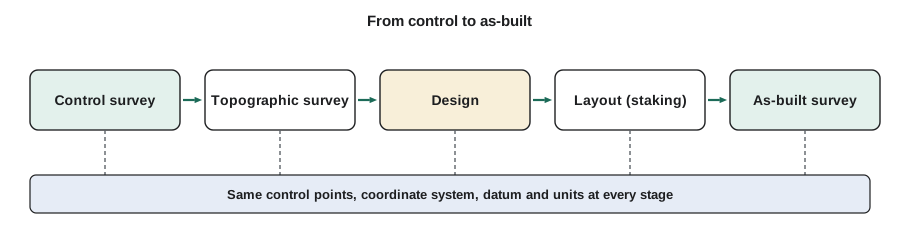
Surveys are often grouped by purpose. The same instruments are used across all of them, but the accuracy needed, the legal weight of the result and the deliverables differ.
- Control surveys establish a framework of accurately positioned points, called control points or monuments, that later surveys tie to. A project control network for a subdivision might consist of a dozen points set with GNSS and traverses, tied to the national or state reference system.
- Topographic surveys measure the shape of the ground and the location of natural and built features, such as trees, fences, buildings, utilities and drainage ditches, to produce a base map for design.
- Boundary or cadastral surveys establish or re-establish property boundaries, create new parcels, and prepare plats for recording with the county. In Montana, only a licensed Professional Land Surveyor may carry out these surveys.
- Construction or layout surveys place stakes, marks and offsets on the ground so that contractors can build what the designers drew, and check grades and alignments as work proceeds.
- As-built surveys measure completed work, such as the actual location and invert elevations of pipes, so that the record drawings reflect reality.
- Monitoring surveys measure small movements over time, for example settlement of a bridge pier, movement of a landslide or deformation of a dam.
- Hydrographic surveys map the bottoms of lakes, rivers and harbours, and mine surveys measure underground workings.
Plane and geodetic surveying
The Earth is roughly an ellipsoid about 6,371 km in mean radius. Over a small area, such as a building site or a subdivision, the curved surface can be treated as a flat plane without significant error. Surveys computed this way are called plane surveys. Over larger areas, or where high accuracy matters, the curvature of the Earth must be considered, and the survey is called geodetic. The difference is small horizontally: over a distance of 10 km, the arc along the Earth's surface and the straight chord differ by less than 1 cm. Vertically the effect is much larger, because the Earth's surface curves away from a horizontal line of sight by about 7.8 cm over 1 km and about 7.8 m over 10 km. Lesson 4 shows how leveling procedures cancel this effect.
In practice, almost every modern project is a hybrid. Control is established in a geodetic reference system with GNSS, then projected onto a map projection so that day-to-day computations can be done in plane coordinates. The projection introduces small, predictable scale distortions that surveyors correct for, as lesson 9 explains.
Units and conventions
In the United States, surveys use feet for most construction and property work, with distances usually recorded to the hundredth of a foot, areas in square feet or acres, and volumes in cubic yards. Angles are measured in degrees, minutes and seconds, where one degree equals 60 minutes and one minute equals 60 seconds. Road alignments are described by stations measured along a centerline in hundreds of feet: station 12+50.00 is 1,250 ft from the start of the alignment. Older plats and legal descriptions use chains (66 feet) and links, which are still found when retracing original township surveys of the Public Land Survey System that covers most of the country west of the original colonies. Federal mapping and GNSS work use meters.
American surveyors must watch for the two feet that have been used in the country. The international foot is defined as exactly 0.3048 m. The US survey foot, defined as 1200/3937 m, is longer by about 2 parts per million, which amounts to about 2 ft in a State Plane coordinate of 1,000,000 ft. The National Geodetic Survey and the National Institute of Standards and Technology deprecated the US survey foot at the end of 2022, so new work uses the international foot, but decades of older coordinates and plans still use the survey foot, and the definition must be checked whenever coordinates in feet are exchanged.
Worked problem
Converting between the two feet
A coordinate is recorded as 1,524,000.00 US survey feet. What is it in meters, and what would the value be if it were wrongly read as international feet?
Show solution
- One US survey foot is 1200/3937 m:
- \[1\,524\,000 \times \frac{1200}{3937} = 464\,516.13\ \text{m}\]
- Reading the same number as international feet gives:
- \[1\,524\,000 \times 0.3048 = 464\,515.20\ \text{m}\]
- The difference is 0.93 m, which is far larger than the accuracy of any modern survey.
Answer: 464,516.13 m. Misreading the unit shifts the point by about 0.9 m, so the foot definition must be stated with every coordinate list in feet.
# Unit conversions used throughout the course
US_FT = 1200 / 3937          # metres per US survey foot
INT_FT = 0.3048              # metres per international foot
CHAIN_FT = 66                # one Gunter's chain in feet

value_ft = 1_524_000.00
m_us = value_ft * US_FT
m_int = value_ft * INT_FT
print(f"{value_ft:,.2f} US survey ft = {m_us:,.3f} m")
print(f"{value_ft:,.2f} international ft = {m_int:,.3f} m")
print(f"difference = {m_us - m_int:.3f} m ({(US_FT/INT_FT - 1)*1e6:.2f} ppm)")

# A distance of 20 chains 35 links from an old township plan
chains, links = 20, 35
feet = (chains + links / 100) * CHAIN_FT
print(f"20 chains 35 links = {feet:.2f} ft = {feet * INT_FT:.3f} m")

# Earth curvature drop over a horizontal sight
R = 6_371_000
for d in (100, 1000, 10_000):
print(f"curvature drop over {d:>6} m = {d**2 / (2*R):.4f} m")1,524,000.00 US survey ft = 464,516.129 m 1,524,000.00 international ft = 464,515.200 m difference = 0.929 m (2.00 ppm) 20 chains 35 links = 1343.10 ft = 409.377 m curvature drop over 100 m = 0.0008 m curvature drop over 1000 m = 0.0785 m curvature drop over 10000 m = 7.8481 m
Who does surveying
Surveying work in the United States is done by several groups. Professional Land Surveyors are licensed by state boards, which in Montana is the Board of Professional Engineers and Professional Land Surveyors, and only a licensed surveyor may establish property boundaries or sign a plat. Licensure typically requires education, experience under a licensed surveyor, and passing the national Fundamentals of Surveying and Principles and Practice of Surveying examinations plus any state-specific examination. Geodesists and geomatics specialists in agencies such as the National Geodetic Survey maintain the national reference system. Survey technicians, often trained in two-year programs, run instruments, process data and draft plans under the direction of licensed professionals. Civil engineers also need a working knowledge of surveying, because they design from survey data, specify the accuracy of layout and judge whether construction meets tolerances.
On the Coulee Ridge project, the division of responsibilities is typical. Ruth is responsible for the legal survey of the subdivision boundary and new lots, and she signs the plan. Grant runs the field crew, sets control and does the construction layout. Theo flies the drone and builds the surface model and GIS deliverables. Leah's job this term is to learn each task, check computations and, by the end of the course, compute a traverse adjustment and stake out a curve on her own.
Field procedure and good practice
Good surveys share some habits that matter more than any particular instrument.
- Work from the whole to the part. Establish accurate control first, then fill in detail from it. Errors in detail then stay local instead of spreading across the project.
- Build in independent checks. Close traverses back on known points, run level loops back to the starting benchmark, measure distances in both directions, and observe angles on both faces of the instrument. A survey with no redundancy can hide a blunder.
- Keep complete, original field records. Whether the notes are handwritten or stored in a data collector, they must show what was measured, when, by whom, with what instrument, and any sketches and remarks needed to understand them later. Legal surveys may be examined in court decades after they were made.
- Calibrate and adjust equipment regularly. A level with a tilted line of sight, a total station with collimation error or a tape that has stretched produces systematic errors that repeat in every measurement.
- Think about safety. Survey crews work near traffic, heavy equipment, excavations, water and overhead power lines. Traffic control plans, high-visibility clothing, awareness of equipment swing radius and care around trenches are part of every field day.
Accuracy and tolerances
No measurement is exact. Each survey must be accurate enough for its purpose, and achieving more accuracy than needed wastes time and money. Construction layout tolerances depend on what is being built: anchor bolts for structural steel may need to be placed within a few millimeters, while rough grading stakes may be acceptable within a few centimeters. Control surveys are specified by accuracy classes or standards that state the maximum allowable error at a given confidence level. Lesson 2 introduces the vocabulary of errors and the statistics surveyors use to describe accuracy.
| Task on the Coulee Ridge project | Typical required accuracy |
|---|---|
| Project control network | About 1 cm horizontally relative to nearby control |
| Benchmarks for drainage design | About 5 mm in elevation over the site |
| Topographic survey of ground | About 3 to 5 cm in elevation on hard surfaces |
| Lot corners on the legal survey | As required by the provincial or state survey standards |
| Curb and gutter layout | About 1 cm in line and grade |
| Rough grading stakes | About 3 to 5 cm |
How the course is organized
The course moves from basic measurements to complete projects. Lessons 2 and 3 cover errors and distance measurement. Lessons 4 and 5 cover leveling, profiles, cross-sections and earthwork volumes. Lessons 6 to 8 cover angles, total stations, traverses and coordinate geometry. Lesson 9 explains datums, map projections and coordinate systems, lesson 10 covers satellite positioning, and lesson 11 covers GIS, lidar, photogrammetry and drones. Lesson 12 brings everything together in construction layout, including the horizontal and vertical curves for the Coulee Ridge Drive extension.
Common mistakes
MistakeTreating a coordinate list as complete without its coordinate system, datum and units.
InsteadAlways record the horizontal and vertical datum, the projection or local system, the units and, for feet, which foot.
MistakeMeasuring once and moving on.
InsteadBuild in redundancy and independent checks so that blunders are caught in the field.
MistakeAssuming that more decimal places means more accuracy.
InsteadAccuracy depends on the instrument, procedure and conditions; report results to a precision that matches them.
MistakeStarting detail surveys before control is established and checked.
InsteadWork from the whole to the part: control first, then detail tied to it.
Summary and key terms
- Surveying measures horizontal and vertical distances and angles, and GNSS adds three-dimensional positions; everything else is computed from these.
- Surveys are grouped as control, topographic, legal, construction, as-built, monitoring and hydrographic surveys.
- Plane surveying ignores Earth curvature over small areas, but curvature matters vertically even over short sights.
- Coordinates are meaningless without their datum, projection and units; the US survey foot and international foot differ by about 2 ppm.
- Only licensed land surveyors may establish legal boundaries; engineers and technicians use survey data for design and construction.
- Good practice means working from the whole to the part, building in checks, keeping original records and calibrating equipment.
- Geomatics
- The discipline covering surveying, satellite positioning, mapping, remote sensing and geographic information systems.
- Control point
- An accurately positioned, monumented point that other surveys tie to.
- Topographic survey
- A survey of the ground shape and features used to prepare a base map for design.
- Cadastral survey
- A survey that establishes or re-establishes property boundaries.
- Plane surveying
- Surveying in which the Earth is treated as flat over the area of the work.
- Station
- A distance measured along an alignment from its starting point.
- International foot
- A foot defined as exactly 0.3048 m.
- US survey foot
- A foot defined as 1200/3937 m, deprecated in the United States at the end of 2022.
Practice problems
Work each problem on paper first, then reveal the answer to check.
Over what distance does Earth curvature cause a drop of about 1 cm below a horizontal line of sight?
Show answer
\(D = \sqrt{2Rc} = \sqrt{2 \times 6\,371\,000 \times 0.01} \approx 357\) m.
Convert 2,000,000.00 US survey feet and 2,000,000.00 international feet to meters. What is the difference?
Show answer
609,601.22 m and 609,600.00 m; the difference is about 1.22 m.
Why is a control survey done before a topographic survey?
Show answer
So that detail is tied to an accurate framework and errors stay local instead of accumulating across the project.
Name three kinds of surveys and the deliverable each produces.
Show answer
Topographic: base map; legal: registered plan or plat; as-built: record drawings of completed work.
Why must legal survey field notes be kept permanently?
Show answer
They may be examined years later in boundary disputes or retracement surveys, and they are the original evidence of what was measured.
Give two examples of systematic errors caused by poorly maintained equipment.
Show answer
A level whose line of sight is tilted, and a tape that has stretched or a total station with collimation error.
Lesson quiz · 5 questions
Score 60% or more to complete this lesson.
Create a free account to save your progress, take quizzes and earn a certificate.