
CIV-440 · Lesson 9 of 12 · 19 min
Slope stabilization and monitoring
Lesson 8 showed that the Kestrel Creek bank falls short of the targets: about 1.45 against 1.5 in summer, and about 1.13 against 1.3 in spring. Something must be done before the MSE wall is built on its crest and the road is widened beside it. Slope stabilization works by one or more of three means: reducing the forces that drive the slide, increasing the forces that resist it, or increasing the strength of the soil, usually by lowering the pore pressures. This lesson compares the options for the bank, chooses one, and sets out how the bank and the new works will be monitored.
Changing the geometry
Flattening a slope, or removing soil from its crest, reduces the driving moment. It is the simplest remedy, but it needs space at the crest, which is often not available, and it can move the problem to the neighbor. Placing weight at the toe, in a berm or buttress of compacted fill or rockfill, increases the resisting moment of circles passing beneath it. A rockfill buttress has the further advantages of high friction and free drainage, and beside a watercourse it protects the toe against erosion. The buttress must itself be stable, and its weight must not cause a deeper failure in soft ground beneath it.
Retaining structures can stabilize a slope directly: a cantilever or anchored wall at the toe, a row of large-diameter piles or shafts through the sliding mass into stable ground, or soil nails and ground anchors installed through the face. These are expensive and are used where geometry changes are impossible, typically next to roads, rail lines and buildings.
Drainage
Because pore pressure reduces the effective normal stress on the slip surface, lowering it is often the most effective single measure. Surface drainage, by ditches at the crest, sealing of cracks and grading to shed water, prevents water from entering the slope. Subsurface drainage lowers the water table within it: trench drains along the slope, horizontal drains drilled into the slope from the toe, drainage galleries in large landslides and relief wells. Horizontal drains, perforated pipes about 2 in. in diameter drilled upward at a few degrees for 65 to 200 ft, are common for road cuts and banks. Their weakness is maintenance: they clog with iron precipitates, roots and fines, and must be flushed and inspected for their effect to last.
Vegetation helps the upper meter or two by intercepting rainfall, drawing water from the soil and reinforcing it with roots, and it protects the surface against erosion. It does little for deep slides, and its effect varies with the seasons, which in a northern climate means that it is weakest in spring, exactly when the bank needs it most.
Improving the soil and reinforcing the slope
Grouting, lime or cement columns, and electro-osmosis improve the strength of the soil in place, but are rarely economical for slopes. Reinforced soil slopes, built with geogrid layers like an MSE wall but with an inclined face, are used for new embankment slopes steeper than the fill could stand alone. Soil nailing, with steel bars grouted into drilled holes and a shotcrete face, stabilizes steep cuts from the top down. The choice among all these measures depends on the mechanism of failure, the space available, the consequences of further movement and the cost.
Worked problem
Comparing stabilization options for the bank
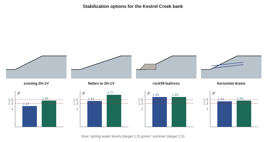
Using the section and the Bishop analysis of lesson 8, compare four options: flattening the bank to 3H:1V; a rockfill buttress 6.5 ft high with a 13 ft wide top at the toe (\(\phi' = 40^\circ\), free-draining); horizontal drains that lower the spring water table to 1 ft at the face and 5 ft below the crest far back; and the buttress with drains.
Show solution
- Each option is analyzed for both water conditions with a coarser grid of trial circles than in lesson 8, so the existing bank shows factors 0.02 higher here.
- \[F_{existing} = 1.16 / 1.46 \qquad F_{3H:1V} = 1.44 / 1.78 \quad (\text{spring / summer})\]
- \[F_{buttress} = 1.65 / 1.65 \qquad F_{drains} = 1.41 / 1.46 \qquad F_{both} = 1.65 / 1.65\]
Answer: Flattening and drains each meet the spring target of 1.3, but drains do not help in summer, when the water table is already low, so the bank would stay just short of 1.5. The buttress meets both targets with a margin. With the buttress in place, the critical circle moves up to the slope above it, which is why adding drains gives no further benefit.
The script reuses the slice routines from lesson 8, with options to change the slope, add a free-draining buttress and lower the water table.
# Stabilizing the Kestrel Creek bank: flatter slope, rockfill toe buttress and horizontal drains (Bishop's method)
from math import tan, radians, sqrt
UNITS = "US"
SI = UNITS == "SI"
L, P = ("m", "kPa") if SI else ("ft", "psf")
k = 1.0 if SI else 3.281                       # length scale: the US section is the same geometry in feet
gw = 9.81 if SI else 62.4
sand = dict(c=0.0, phi=34.0, g=19.0 if SI else 121.0)
clay = dict(c=5.0 if SI else 105.0, phi=27.0, g=18.0 if SI else 115.0)
Hb, y_int = 5.0 * k, 3.0 * k           # bank height, slope n:1, sand above elevation y_int, clay below
q, xq = (12.0 if SI else 250.0), 4.0 * k        # road surcharge starting 4 m | 13 ft behind the crest
OPT = dict(n=2.0, butt=0.0, drains=False)       # slope, buttress height above the toe, drains
rock = dict(c=0.0, phi=40.0, g=20.0 if SI else 127.0)
def ground(x):
    n = OPT["n"]; base = 0.0 if x <= 0 else (x / n if x <= n * Hb else Hb)
    bw = 4.0 * k                                 # buttress: flat top 4 m | 13 ft wide from the toe, then 1.5H:1V down to the bed
    if OPT["butt"] > 0 and -1.5 * OPT["butt"] < x <= bw + 0.0:
        top = OPT["butt"] if x >= 0 else OPT["butt"] + x / 1.5
        return max(base, top)
    return base
WATER = {"summer": (0.3, 2.0), "spring": (1.5, 0.5), "spring with drains": (0.3, 1.5)}   # water level at the bank face above the toe, depth below the crest far back
def phreatic(x, case):
    yf, db = WATER[case]; yf *= k; yb = Hb - db * k; xb = OPT["n"] * Hb + 6 * k
    if OPT["butt"] > 0 and x <= 4.0 * k: return min(0.3 * k, ground(x))   # free-draining rockfill: water at creek level
    if x <= 0: return min(yf, ground(x))
    y = yf + (yb - yf) * min(x / xb, 1.0)
    return min(y, ground(x))
def slices(xc, yc, R, case, N=60):
    out = []; dx = 2 * R / N
    for i in range(N):
        x = xc - R + (i + 0.5) * dx
        yb = yc - sqrt(max(R * R - (x - xc) ** 2, 0)); yt = ground(x)
        h = yt - yb
        if h <= 0: continue
        nat = 0.0 if x <= 0 else min(x / OPT["n"], Hb)   # natural ground below any buttress
        hr = max(0.0, yt - max(yb, nat)) if yt > nat else 0.0
        hs = max(0.0, min(yt, nat) - max(yb, y_int)); hc = max(0.0, h - hs - hr)
        W = (sand["g"] * hs + clay["g"] * hc + rock["g"] * hr) * dx + (q * dx if x >= OPT["n"] * Hb + xq else 0.0)
        u = max(0.0, phreatic(x, case) - yb) * gw
        soil = rock if yb >= nat and hr > 0 else (sand if yb >= y_int else clay)
        s = (x - xc) / R; cth = sqrt(1 - s * s)
        out.append((W, u, soil, s, cth, dx))
    return out
def fs_ordinary(sl):
    if sum(W * s for W, u, sm, s, ca, dx in sl) <= 0: return 99
    num = sum(sm["c"] * dx / ca + (W * ca - u * dx / ca) * tan(radians(sm["phi"])) for W, u, sm, s, ca, dx in sl)
    den = sum(W * s for W, u, sm, s, ca, dx in sl)
    return num / den if den > 0 else 99
def fs_bishop(sl):
    F = fs_ordinary(sl)
    if F >= 99 or F <= 0: return 99
    for _ in range(50):
        num = 0.0
        for W, u, sm, s, ca, dx in sl:
            tp = tan(radians(sm["phi"])); m = max(ca + s * tp / F, 0.2)
            num += (sm["c"] * dx + (W - u * dx) * tp) / m
        den = sum(W * s for W, u, sm, s, ca, dx in sl)
        Fn = num / den
        if abs(Fn - F) < 1e-5: break
        F = Fn
    return Fn if Fn > 0 else 99
def search():
    best = 99
    for i in range(-6, 19):
        for j in range(0, 15):
            xc, yc = i * 0.5 * k, Hb + j * 0.5 * k
            for d in (0, 2, 4, 6):
                sl = slices(xc, yc, yc + d * 0.5 * k, CASE)
                if len(sl) >= 5: best = min(best, fs_bishop(sl))
    return best
options = [("existing bank, 2H:1V", dict(n=2.0, butt=0.0), "spring"),
           ("flatten to 3H:1V", dict(n=3.0, butt=0.0), "spring"),
           ("rockfill buttress " + ("2 m" if SI else "6.5 ft") + " high", dict(n=2.0, butt=2.0 * k), "spring"),
           ("horizontal drains only", dict(n=2.0, butt=0.0), "spring with drains"),
           ("buttress plus drains", dict(n=2.0, butt=2.0 * k), "spring with drains")]
for name, o, wet in options:
    OPT.update(o); CASE = wet; Fs = search()
    CASE = "summer"; Fu = search()
print(f"{name:38s} spring FS = {Fs:.2f} summer FS = {Fu:.2f}")existing bank, 2H:1V spring FS = 1.16 summer FS = 1.46 flatten to 3H:1V spring FS = 1.44 summer FS = 1.78 rockfill buttress 6.5 ft high spring FS = 1.65 summer FS = 1.65 horizontal drains only spring FS = 1.41 summer FS = 1.46 buttress plus drains spring FS = 1.65 summer FS = 1.65
The choice
Flattening the bank to 3H:1V would need a cut of about 16 ft at the crest, which is where the road is being widened and the MSE wall is to stand; it is not possible. Horizontal drains alone would bring the spring condition up to the target but leave the summer condition slightly short, and their performance depends on maintenance that a small municipal works department may not keep up. The rockfill buttress meets both targets, protects the toe from the creek's erosion and needs little maintenance. It narrows the creek channel slightly, so the water resources engineer, Anika Rao, checks its effect on the flood levels at the culvert from Hydraulics & Hydrology: the change is small because the buttress is placed on the inside of the bend, where the channel is widest.
The design therefore adopts a rockfill buttress 6.5 ft high with a 13 ft top, a riprap face toward the creek sized for the 100-year velocities, and a geotextile filter between the buttress and the bank to stop the sand from washing into the rock. The rockfill drains the toe of the bank and so lowers the water level at the face, which the analysis includes. Work in the creek needs the approvals of the state natural resources agency and the U.S. Army Corps of Engineers under the Clean Water Act, and must be done in the low-flow season.
Monitoring
Monitoring confirms that a slope behaves as the design assumed, warns of trouble early and provides the data for back-analysis if it does not. The common instruments are:
- Inclinometers: casings grouted into boreholes through the sliding mass into stable ground, surveyed with a probe that measures their tilt every half meter. Repeated surveys show the depth and rate of movement. They are the most important instrument for slopes.
- Piezometers: vibrating wire or standpipe piezometers sealed at chosen depths, read manually or by a data logger, to measure the pore pressures on which the analysis depends.
- Survey monuments and prisms, read by total station or GNSS, and, for larger areas, satellite radar interferometry, which measures millimeter movements of the ground surface over wide areas.
- Visual inspection, after floods, heavy rain and the spring melt, for cracks, bulges, seepage and erosion.
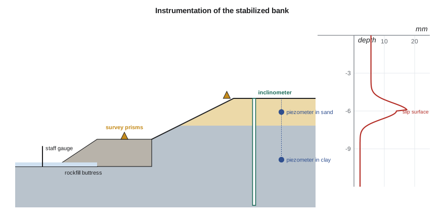
Monitoring must have a purpose and a plan: who reads the instruments, how often, who looks at the results and what happens when a reading crosses a threshold. The team sets review levels for the bank: an alert level of 0.2 in. of movement in a month at the inclinometer, or a piezometric level in the sand within 1.5 ft of the spring design level, triggers more frequent readings and an inspection; an action level of twice those values triggers a meeting of the owner and the engineer to decide on further measures. The observational method, set out by Peck in 1969, takes this a step further: the design is based on the most probable conditions, with planned modifications ready to be applied if monitoring shows that conditions are less favorable. It is well suited to slopes, where parameters are uncertain and movements give warning.
| Instrument | Measures | Location at Kestrel Creek | Frequency |
|---|---|---|---|
| Inclinometer | lateral movement with depth | crest, through the clay into the till | monthly for a year, then twice a year |
| Vibrating wire piezometers | pore pressure | sand and clay at the crest | logger, daily |
| Survey prisms | surface movement | crest, buttress, MSE wall facing | monthly, then quarterly |
| Staff gauge | creek level | at the culvert | with each visit |
| Inspection | cracks, seepage, erosion | whole bank | after floods and each spring |
Practical points
- Identify the mechanism of failure before choosing a remedy.
- Compare options for both the governing and the ordinary condition; a remedy that helps one may not help the other.
- Use buttresses and drainage first; structures are for sites where geometry cannot change.
- Provide filters between soil and rockfill or drains.
- Monitor with a purpose: defined instruments, frequencies, thresholds and responses.
Common mistakes
MistakeRelying on horizontal drains with no plan for maintenance.
InsteadDrains clog; budget for flushing and check their discharge.
MistakePlacing rockfill directly against sand.
InsteadUse a graded filter or geotextile so the sand does not wash into the voids.
MistakeInstalling instruments with no one assigned to read them.
InsteadA monitoring plan needs responsibilities, thresholds and actions.
MistakeAssuming a buttress always helps.
InsteadOn soft ground, its weight can cause a deeper failure; check circles below it.
Summary and key terms
- Stabilization reduces driving forces, increases resisting forces or raises strength, usually by drainage.
- Buttresses add weight at the toe; rockfill also drains and protects against erosion.
- Drainage lowers pore pressures; horizontal drains need maintenance.
- For the Kestrel Creek bank, a 6.5 ft rockfill buttress raises \(F\) to 1.65 in both seasons.
- Monitoring uses inclinometers, piezometers, surveys and inspection, with thresholds and planned responses.
- The observational method designs for the probable case and plans modifications in advance.
- Buttress
- A mass of fill or rockfill placed at the toe of a slope to increase its stability.
- Horizontal drain
- A perforated pipe drilled into a slope at a slight upward angle to lower the water table.
- Soil nailing
- Stabilization of a cut by steel bars grouted into the soil with a reinforced shotcrete facing.
- Reinforced soil slope
- An embankment slope steepened with horizontal geosynthetic reinforcement.
- Inclinometer
- An instrument that measures lateral ground movement with depth in a borehole casing.
- Vibrating wire piezometer
- An electronic piezometer that measures pore pressure from the frequency of a tensioned wire.
- Observational method
- Peck's approach of designing for probable conditions and modifying the design as monitoring dictates.
- Filter
- A graded layer or geotextile that lets water pass while retaining the soil particles.
Practice problems
Work each problem on paper first, then reveal the answer to check.
A bank has \(F = 1.15\) with a spring water table and \(F = 1.45\) without it. Drains bring the spring water table down to the summer level. What factor of safety would you expect in spring, and does it meet a 1.5 long-term target?
Show answer
About 1.45, the summer value; it does not quite meet 1.5, so drainage alone is not enough.
Why does a rockfill buttress beside a creek need a filter against the bank?
Show answer
Seepage from the bank would carry the sand into the voids of the rockfill, undermining the bank and clogging the rock.
An inclinometer shows 0.16 in. of movement at a depth of 20 ft over two months, with none above or below. What does this indicate?
Show answer
A slip surface at about that depth moving slowly; increase the reading frequency and compare with the piezometers and the alert level.
Describe the observational method in one sentence.
Show answer
Design for the most probable conditions, monitor the behavior, and have planned modifications ready to apply if the observations show less favorable conditions.
Lesson quiz · 5 questions
Score 60% or more to complete this lesson.
Create a free account to save your progress, take quizzes and earn a certificate.