
GEOM-210 · Lesson 4 of 12 · 25 min
Differential levelling
Elevations control drainage, and drainage controls much of civil engineering. Sewers and storm drains flow by gravity, roads must shed water, building floors must sit above flood levels and foundations must be founded at design depths. Differential levelling is the most precise everyday method of measuring differences in elevation. It uses a level, an instrument that defines a horizontal line of sight, and a graduated rod held on the points being measured. This lesson covers the equipment, the field procedure, booking and arithmetic checks, closure and adjustment of level loops, and the tests that keep a level in adjustment.
On the Coulee Ridge project, the storm sewer and the stormwater pond will be designed to slopes as flat as 0.5 per cent. A 5 mm error in a benchmark elevation would be a tenth of the fall over 10 m of pipe, so Grant's crew establishes new benchmarks by careful levelling from the existing municipal benchmark network rather than relying on GNSS heights alone.
Datums and benchmarks
Elevations are measured from a vertical datum, a reference surface close to mean sea level. Canada's official vertical datum is CGVD2013, which is defined by a model of the geoid rather than by a network of levelled benchmarks; the older CGVD28 datum, based on levelling, is still used in many municipal systems and on older drawings. Lesson 9 explains the difference. A benchmark is a stable, permanently marked point of known elevation, such as a brass disk set in concrete, a bolt in a structure or a rod driven to refusal. Municipalities and provincial agencies publish benchmark elevations, and every project establishes its own site benchmarks tied to them.
Always confirm which datum a benchmark elevation refers to. The difference between an old and a new datum in the same place can be tens of centimetres or more, and mixing them in one design has caused real drainage failures.
Levels and rods
An automatic level contains a compensator, a pendulum-mounted optical element that keeps the line of sight horizontal once the instrument is roughly levelled with its circular bubble. A digital level reads a bar-coded rod electronically, eliminating reading and booking mistakes and storing the observations. A rotating laser level sweeps a horizontal or sloping plane of laser light that detectors on rods or machines can sense, which makes it popular for construction grading but less precise than optical levelling over long distances.
Levelling rods are graduated in metres, decimetres and centimetres, and the observer estimates millimetres. Rods are often telescopic or folding, 4 m or 5 m long, and must be held plumb, usually with a rod level, because a tilted rod always reads too high. For the most precise work, invar strip rods with digital levels are used.
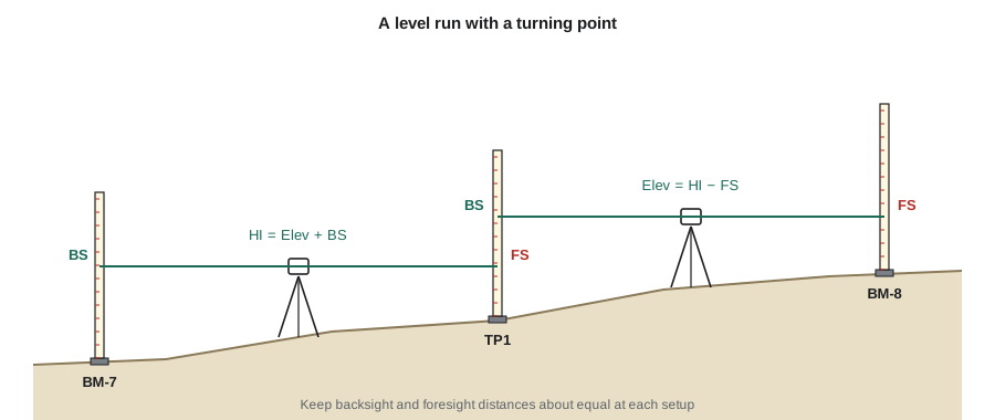
The height of instrument method
A level is set up roughly midway between a point of known elevation and the next point. The observer reads the rod on the known point, called a backsight (BS), and adds it to the known elevation to get the height of instrument (HI), the elevation of the line of sight. The rod is then moved to the next point, and the reading there, called a foresight (FS), is subtracted from the HI to get that point's elevation.
When the route is longer than a single setup, the rod is placed on a temporary, stable point called a turning point (TP). After the foresight on the turning point, the level is moved forward and a backsight is taken on the same turning point. Turning points can be a steel pin, a solid rock or a manufactured turning plate, but they must not move while the level is moved. Additional readings on points that are not part of the route, called intermediate sights or side shots, give elevations of ground points or structures but do not carry the route forward.
The arithmetic check for a level run is simple and catches computation mistakes: the difference between the starting and ending elevations must equal the sum of the backsights minus the sum of the foresights (excluding intermediate sights).
An alternative booking method, the rise and fall method, computes the difference between each consecutive pair of readings as a rise or a fall. It requires more arithmetic but includes a check on every intermediate sight, so it is preferred where many intermediate elevations are critical.
Closing the loop
A level run that ends on a different benchmark of known elevation, or returns to its starting benchmark in a closed loop, has a built-in check. The misclosure is the computed elevation of the closing benchmark minus its known elevation. Random errors make some misclosure inevitable; the question is whether it is small enough.
Survey standards express the allowable misclosure in terms of the length of the route, because random errors accumulate with the square root of the number of setups, which is roughly proportional to the square root of the distance. A typical form is:
where \(K\) is the length of the route in kilometres and \(C\) is a constant for the accuracy class, in millimetres. Values around 4 mm are used for precise geodetic work and around 12 mm for ordinary engineering and construction levelling. Project specifications state the value to use.
If the misclosure is within the allowable value, it is distributed through the run. The usual simple adjustment assumes that error accumulates in proportion to distance, so each point receives a correction proportional to its cumulative distance from the start. Where setups are similar in length, the number of setups can be used instead.
Worked problem
Closing and adjusting a level loop
Grant's crew runs a loop from benchmark BM-7 (elevation 912.436 m) through turning points TP1 and TP2 to new benchmark BM-8, then through TP3 back to BM-7. The readings are: BS 1.524 on BM-7, FS 0.876 on TP1; BS 2.315 on TP1, FS 1.042 on TP2; BS 0.633 on TP2, FS 2.147 on BM-8; BS 1.106 on BM-8, FS 2.411 on TP3; BS 1.778 on TP3, FS 0.874 on BM-7. The setups cover 80, 90, 70, 100 and 60 m. Find the misclosure, check it against 12 mm√K, and compute the adjusted elevation of BM-8.
Show solution
- Compute heights of instrument and elevations: \(HI_1 = 912.436 + 1.524 = 913.960\); TP1 \(= 913.084\); \(HI_2 = 915.399\); TP2 \(= 914.357\); \(HI_3 = 914.990\); BM-8 \(= 912.843\); \(HI_4 = 913.949\); TP3 \(= 911.538\); \(HI_5 = 913.316\); BM-7 \(= 912.442\).
- Arithmetic check: \(\sum BS - \sum FS = 7.356 - 7.350 = +0.006\) m, which equals \(912.442 - 912.436\).
- The misclosure is +6 mm over 400 m. The allowable value is:
- \[12\sqrt{0.400} = 7.6\ \text{mm}\]
- The loop is acceptable. BM-8 is 240 m along the 400 m loop, so its correction is:
- \[-6 \times \frac{240}{400} = -3.6\ \text{mm}\]
- \[\text{Elev}_{BM8} = 912.843 - 0.0036 = 912.839\ \text{m}\]
Answer: The misclosure of +6 mm is within the 7.6 mm allowance, and the adjusted elevation of BM-8 is 912.839 m. If the misclosure had exceeded the allowance, the crew would have rerun the loop, starting with the setups that showed the most suspicious readings.
# Height-of-instrument reduction, closure check and adjustment of a level loop
import math

start_elev = 912.436
# (backsight point, BS, foresight point, FS, setup length m)
setups = [("BM-7", 1.524, "TP1", 0.876, 80),
          ("TP1", 2.315, "TP2", 1.042, 90),
          ("TP2", 0.633, "BM-8", 2.147, 70),
          ("BM-8", 1.106, "TP3", 2.411, 100),
          ("TP3", 1.778, "BM-7", 0.874, 60)]

elev, cum, rows = start_elev, 0, []
for bs_pt, bs, fs_pt, fs, length in setups:
    hi = elev + bs
    elev = hi - fs
    cum += length
    rows.append((fs_pt, hi, elev, cum))

mis = elev - start_elev
total = cum
allow = 12 * math.sqrt(total / 1000) / 1000
print(f"sum BS - sum FS = {sum(s[1] for s in setups) - sum(s[3] for s in setups):+.3f} m")
print(f"misclosure = {mis*1000:+.1f} mm, allowable = {allow*1000:.1f} mm, ok = {abs(mis) <= allow}")
for pt, hi, e, c in rows:
    adj = e - mis * c / total
print(f"{pt:5} HI {hi:9.3f} elev {e:9.3f} adjusted {adj:9.3f}")sum BS - sum FS = +0.006 m misclosure = +6.0 mm, allowable = 7.6 mm, ok = True TP1 HI 913.960 elev 913.084 adjusted 913.083 TP2 HI 915.399 elev 914.357 adjusted 914.354 BM-8 HI 914.990 elev 912.843 adjusted 912.839 TP3 HI 913.949 elev 911.538 adjusted 911.533 BM-7 HI 913.316 elev 912.442 adjusted 912.436
Systematic errors and how procedure cancels them
Several systematic errors affect levelling. The good news is that a simple habit, keeping backsight and foresight distances equal at each setup, cancels most of them.
- Collimation error: if the line of sight is not exactly horizontal when the instrument is level, every reading is too high or too low by an amount proportional to the sight distance. With equal backsight and foresight distances the error is the same in both readings and cancels in their difference.
- Earth curvature and atmospheric refraction: a horizontal line of sight rises above the curved level surface, while refraction bends the line of sight slightly back toward the Earth. Their combined effect makes a rod reading too high by approximately:
For a 100 m sight this is only 0.7 mm, but for a 500 m sight it is 17 mm. With balanced sights the effect cancels; when it cannot be balanced, as in trigonometric levelling over long lines, it must be computed and applied.
- Rod errors: a rod that is not plumb reads high, a rod with a worn or damaged base gives a constant offset (which cancels when the same rod is used for backsights and foresights), and rod sections that are not fully extended give gross errors.
- Settlement: a tripod or turning point that sinks between readings causes errors that accumulate along the route. Firm ground, turning plates and quick, regular reading sequences reduce the effect.
- Heat shimmer and refraction near the ground make readings unsteady and can bend sight lines systematically; keeping sights short and readings at least half a metre above the ground helps, and precise levelling avoids the hottest part of the day.
The two-peg test
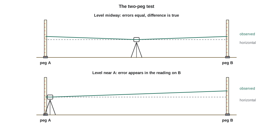
The two-peg test checks a level's collimation error. Two pegs or stable points are set 50 to 60 m apart. The level is first set exactly midway, and readings on both pegs give the true difference in elevation, because any collimation error is equal in both readings. The level is then set close to one peg, and readings are taken again. If the difference computed from the second setup differs from the true difference, the line of sight is tilted.
Worked problem
A two-peg test
Pegs A and B are 60 m apart. With the level midway, the readings are A 1.432 m and B 1.218 m. With the level 3 m from A, the readings are A 1.505 m and B 1.297 m. Is the level in adjustment?
Show solution
- True difference from the midpoint setup: B is higher than A by \(1.432 - 1.218 = 0.214\) m.
- From the second setup, the reading on B should have been \(1.505 - 0.214 = 1.291\) m.
- The observed reading is 1.297 m, so the line of sight rises by 6 mm over the 57 m from the instrument to B, ignoring the tiny effect on the 3 m sight to A.
- \[\text{collimation error} \approx \frac{0.006}{57} \times 206\,265 \approx 22''\]
Answer: The line of sight is inclined upward by about 22 seconds, or about 1 mm per 10 m of sight. That is larger than most specifications allow for engineering levelling, so the level should be adjusted or serviced; in the meantime, balanced sights would still cancel the error.
Other ways to measure height
Trigonometric levelling with a total station, described in lesson 3, measures elevation differences from slope distances and zenith angles. It is fast, works across rough terrain and is standard for topographic surveys, but it is limited by uncertainty in instrument and target heights, zenith angle precision and refraction, so it is generally less precise than differential levelling over the same distance.
Reciprocal levelling is used where sights cannot be balanced, such as across a river or ravine. Readings are taken from both sides, and averaging the two computed differences cancels collimation error and curvature and refraction.
GNSS gives ellipsoid heights, which must be converted to elevations with a geoid model, as lesson 9 explains. Modern geoid models are good to a few centimetres in most areas, which is adequate for topography and many layout tasks but not for establishing benchmarks for flat drainage designs. That is why Grant's crew levelled BM-8 rather than relying on GNSS.
Booking and field practice
- Record readings immediately and read them back; the rod person should confirm the rod was plumb and on the correct point.
- Balance backsight and foresight distances at each setup by pacing or with the level's stadia hairs.
- Keep sights under about 60 to 90 m for engineering levelling, and shorter in heat or for precise work.
- Use solid turning points, mark them, and do not move the rod off a turning point until the next backsight is read.
- Do the arithmetic check on every page and close every run on a known benchmark before leaving the field.
- Describe new benchmarks fully, with sketches and ties to permanent features, so that others can find and trust them.
Common mistakes
MistakeMoving the rod off a turning point before the new backsight is read.
InsteadThe turning point must stay undisturbed until the level has been moved and the backsight taken.
MistakeMaking long foresights and short backsights to save time.
InsteadBalance sight distances so collimation error and curvature cancel.
MistakeIncluding intermediate sights in the arithmetic check sums.
InsteadThe check uses only backsights and foresights on points that carry the route.
MistakeUsing a benchmark elevation without checking its datum.
InsteadConfirm the vertical datum, because old and new datums can differ by tens of centimetres or more.
Summary and key terms
- A backsight on a known point gives the height of instrument; foresights give new elevations; turning points carry the route forward.
- The arithmetic check is: change in elevation equals the sum of backsights minus the sum of foresights.
- Allowable misclosure takes the form C√K; acceptable misclosures are distributed in proportion to distance.
- Balanced sight distances cancel collimation error and the combined effect of curvature and refraction, about 0.0675 K² m.
- The two-peg test measures collimation error by comparing readings from a midway setup and an end setup.
- Trigonometric, reciprocal and GNSS methods also give heights, but differential levelling remains the most precise everyday method.
- Benchmark
- A stable, marked point of known elevation.
- Backsight
- A rod reading on a point of known elevation, used to find the height of instrument.
- Foresight
- A rod reading on a point whose elevation is to be found.
- Height of instrument
- The elevation of the level’s line of sight.
- Turning point
- A temporary stable point used to carry a level route forward between setups.
- Misclosure
- The difference between the computed and known elevation of a closing benchmark.
- Collimation error
- The inclination of a level’s line of sight from horizontal.
- Two-peg test
- A field test that measures a level’s collimation error.
Practice problems
Work each problem on paper first, then reveal the answer to check.
BS on a benchmark of elevation 905.112 m is 1.873 m and the FS on a new point is 0.654 m. Find the new elevation.
Show answer
HI = 906.985 m; elevation = 906.331 m.
A level loop 1.6 km long misses closure by 13 mm. Is it acceptable at 12 mm√K?
Show answer
Allowable \(12\sqrt{1.6} = 15.2\) mm, so yes.
What is the combined curvature and refraction effect on a 300 m sight?
Show answer
\(0.0675 \times 0.3^2 = 0.006\) m.
A loop with misclosure +9 mm is 900 m long. What correction does a point 300 m from the start receive?
Show answer
\(-9 \times 300/900 = -3\) mm.
Why does a tilted rod always read too high?
Show answer
The reading on a tilted rod is the slant length to the line of sight, which is longer than the vertical height.
Why are backsight and foresight distances balanced?
Show answer
So that collimation error and curvature and refraction affect both readings equally and cancel.
Lesson quiz · 5 questions
Score 60% or more to complete this lesson.
Create a free account to save your progress, take quizzes and earn a certificate.