
GEOM-210 · Lesson 3 of 12 · 25 min
Distance measurement: taping and EDM
Distance is the most basic surveying measurement. For centuries it was measured with chains, then with steel tapes; today almost all survey distances are measured electronically by total stations or derived from satellite positions. Steel tapes are still used for short layout measurements, building dimensions and checks, and understanding tape corrections is good training in recognizing systematic errors. This lesson covers rough methods, precise taping and its corrections, electronic distance measurement (EDM), and the reduction of a measured slope distance to the horizontal distance that plans and coordinates require.
Surveyors always report horizontal distances on plans, because the horizontal distance between two points does not depend on the route or the slope of the ground. A distance measured along sloping ground, or along the line of sight between a total station and a prism at different heights, is a slope distance and must be reduced to the horizontal.
Rough methods
For reconnaissance and rough checks, distances can be estimated by pacing, by a vehicle odometer or by a handheld laser rangefinder. A surveyor who has calibrated their pace over a known distance can usually pace within about 1 part in 50 to 1 part in 100 on level ground. A recreational GNSS receiver or phone gives positions good to a few metres, useful for finding control monuments but not for measurement. These methods are valuable for planning and for catching gross mistakes, such as a layout stake placed a full tape length wrong.
Taping
Survey tapes are made of steel or, for rough work, fibreglass. A typical steel tape is 30 m or 50 m long, about 6 mm wide and graduated in millimetres. Taping on sloping ground is done either by holding the tape horizontal and using a plumb bob to transfer the end to the ground, called breaking tape on steep slopes, or by measuring along the slope and computing the horizontal distance from the slope and the elevation difference.
A steel tape is accurate only under the conditions at which it was standardized: a particular temperature, a particular pull, and either supported along its full length or suspended between its ends. When field conditions differ, the tape's true length changes, and corrections must be applied. These are classic systematic errors.
| Error source | Effect | Correction |
|---|---|---|
| Incorrect tape length | Every full tape length is wrong by the same amount | Proportional to the measured distance, from the calibration certificate |
| Temperature | Steel expands when warm and contracts when cold | \(C_t = \alpha L (T - T_s)\) |
| Tension (pull) | A stronger pull stretches the tape | \(C_p = (P - P_s) L / (A E)\) |
| Sag | A suspended tape hangs in a curve, so the chord is shorter than the tape | \(C_s = -w^2 L^3 / (24 P^2)\) per suspended span |
| Slope | Distance measured along the slope exceeds the horizontal distance | \(H = \sqrt{L^2 - h^2}\) or \(H = L \cos \alpha\) |
| Misalignment and plumbing | Tape off line or ends not plumbed accurately | Prevented by careful field procedure |
For steel, the coefficient of thermal expansion is about \(\alpha = 0.0000116\) per °C. Standard conditions are often 20 °C and a pull of 50 N with the tape fully supported. A 30 m tape used at −10 °C, a common winter temperature in southern Alberta, is about 10 mm shorter than at 20 °C, so every measurement would read long by about 1 part in 2,900 if uncorrected.
The sign of each correction follows from the physics. If the tape is shorter than it should be, because it is cold or has been calibrated short, the measured distance is too large and the correction is negative. When laying out a design distance, the signs reverse: the surveyor must measure a different nominal value so that the true distance comes out right. Mixing up measuring and laying out is a classic mistake.
Worked problem
Correcting a taped distance
Leah tapes a property line along a slope with a 30 m steel tape and records a slope distance of 87.432 m. The calibration certificate gives the tape's length as 30.004 m at 20 °C, 50 N pull, fully supported. During the measurement the temperature is −8 °C, the pull is 70 N, the tape is fully supported on the ground, and the tape has a cross-sectional area of 3.0 mm² with E = 200,000 MPa. The elevation difference between the ends is 2.85 m. Find the horizontal distance.
Show solution
- Standardization: the tape is 4 mm long per 30 m, so the true distance is longer than recorded:
- \[C_{std} = \frac{0.004}{30} \times 87.432 = +0.0117\ \text{m}\]
- \[C_t = 0.0000116 \times 87.432 \times (-8 - 20) = -0.0284\ \text{m}\]
- \[C_p = \frac{(70 - 50) \times 87.432}{3.0 \times 200\,000} = +0.0029\ \text{m}\]
- Corrected slope distance: \(87.432 + 0.0117 - 0.0284 + 0.0029 = 87.4182\) m.
- \[H = \sqrt{87.4182^2 - 2.85^2} = 87.3717\ \text{m}\]
Answer: The horizontal distance is 87.372 m. The cold temperature correction is the largest, and ignoring it alone would make the distance about 28 mm too long, or about 1 part in 3,000.
Sag matters only when the tape is suspended between supports, as when taping over brush or a ditch. For a 30 m span of a tape weighing 0.2 N/m held at 50 N, the sag correction is \(-0.2^2 \times 30^3 / (24 \times 50^2) = -0.018\) m, a large error that is avoided by supporting the tape or by applying a higher pull. There is a particular pull, called the normal tension, at which the stretch from tension exactly cancels the shortening from sag, and some surveyors use it for suspended taping.
Electronic distance measurement
EDM instruments measure distance by sending a beam of infrared or visible laser light to a target and timing or comparing the returned signal. Since the 1970s EDM has replaced taping for almost all survey distances, and today it is built into every total station. Two principles are used.
- Phase comparison: the instrument modulates the light beam with signals of known wavelength and measures the phase difference between the outgoing and returning signals. The phase difference gives the fractional part of a wavelength, and several modulation frequencies resolve the whole number of wavelengths. Phase instruments are very precise over distances up to a few kilometres to a prism.
- Pulse or time of flight: the instrument sends short laser pulses and measures the round-trip travel time. Since light travels about 300 mm per nanosecond, timing must be extremely precise. Pulse methods allow measurements without a prism, called reflectorless measurement, to walls, pavements and structures, typically up to several hundred metres.
Measurements to a glass prism are the most accurate. Every prism has a prism constant, an offset that accounts for the slower speed of light inside the glass and the position of the prism relative to its pole. The constant, often between 0 and −40 mm depending on the prism and holder, must be set correctly in the instrument; using the wrong constant adds the same error to every distance and is a common source of systematic error when crews mix equipment.
EDM accuracy is specified in two parts: a constant part, in millimetres, and a part proportional to distance, in parts per million (ppm). A total station specified as ±(1 mm + 1.5 ppm) to a prism has an expected standard deviation of about 1 mm plus 1.5 mm per kilometre, or about 1.8 mm at 523 m. Reflectorless measurements are typically somewhat less precise, depending on the surface.
Atmospheric and instrument corrections
Light travels slightly slower in air than in a vacuum, and the speed depends on air temperature, pressure and, to a lesser degree, humidity. The instrument assumes standard conditions; if the actual conditions differ, the distance must be corrected. Modern total stations apply the correction automatically when the crew enters the temperature and pressure. A rule of thumb for infrared EDM is that the correction changes by roughly 1 ppm for each 1 °C change in temperature and roughly 0.3 ppm for each 1 hPa change in pressure.
In southern Alberta the elevation is around 900 m, so the air pressure is about 900 hPa rather than the 1,013 hPa of sea level. Entering sea-level pressure instead of the actual pressure would introduce an error of about 35 ppm, or about 17 mm over 500 m, which is much larger than the instrument's precision. Crews therefore measure temperature and pressure at the start of the day and whenever conditions change.
Instruments also have small constant and scale errors of their own. They are checked periodically on a calibration baseline, a set of monuments at precisely known distances that many surveying associations, governments and universities maintain. Measuring all combinations of distances between baseline pillars reveals the instrument's zero error and scale error, which can then be applied as corrections.
Reducing slope distances
A total station measures the slope distance \(S\) along the line of sight and the zenith angle \(z\), the vertical angle measured downward from straight up. Zenith angles are about 90° for a level sight, less than 90° when sighting uphill and more than 90° when sighting downhill. The horizontal distance and the vertical component are:
The difference in elevation between the ground marks then includes the height of the instrument above its mark, \(h_i\), and the height of the prism above its mark, \(h_r\). This trigonometric levelling is less precise than differential levelling, described in lesson 4, but it is fast and widely used for topographic surveys.
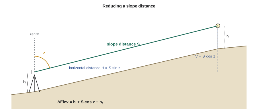
Worked problem
Horizontal distance and elevation difference from a total station
From control point CR-3, Grant measures to a prism on CR-4: slope distance 523.418 m, zenith angle 86°42′15″. The instrument height is 1.580 m and the prism height is 1.800 m. Find the horizontal distance and the elevation difference from CR-3 to CR-4.
Show solution
- Convert the zenith angle: \(z = 86 + 42/60 + 15/3600 = 86.7042°\).
- \[H = 523.418 \sin 86.7042° = 522.552\ \text{m}\]
- \[V = 523.418 \cos 86.7042° = 30.092\ \text{m}\]
- \[\Delta \text{Elev} = 1.580 + 30.092 - 1.800 = 29.872\ \text{m}\]
Answer: The horizontal distance is 522.552 m, and CR-4 is 29.872 m higher than CR-3. For sights longer than a few hundred metres, the computation also corrects for Earth curvature and atmospheric refraction, as lesson 4 explains; most total stations apply that correction automatically.
# Tape corrections and slope reduction (metric example)
import math

def tape_corrections(L, tape_len, nominal, T, Ts, P, Ps, A_mm2, E_mpa, alpha=0.0000116):
    c_std = (tape_len - nominal) / nominal * L
    c_t = alpha * L * (T - Ts)
    c_p = (P - Ps) * L / (A_mm2 * E_mpa)
    return c_std, c_t, c_p

L = 87.432
cs, ct, cp = tape_corrections(L, 30.004, 30.0, -8, 20, 70, 50, 3.0, 200_000)
Lc = L + cs + ct + cp
H = math.sqrt(Lc**2 - 2.85**2)
print(f"standardization {cs:+.4f}  temperature {ct:+.4f}  tension {cp:+.4f}")
print(f"corrected slope distance {Lc:.4f} m, horizontal {H:.4f} m")

# Sag correction for a 30 m suspended span
w, P, span = 0.2, 50, 30
print(f"sag correction = {-w**2 * span**3 / (24 * P**2):.4f} m")

# Total station reduction
S = 523.418
z = math.radians(86 + 42/60 + 15/3600)
hi, hr = 1.580, 1.800
print(f"H = {S*math.sin(z):.3f} m, V = {S*math.cos(z):.3f} m, dElev = {hi + S*math.cos(z) - hr:.3f} m")
print(f"EDM spec 1 mm + 1.5 ppm at {S:.0f} m: {1 + 1.5 * S / 1000:.1f} mm")standardization +0.0117 temperature -0.0284 tension +0.0029 corrected slope distance 87.4182 m, horizontal 87.3717 m sag correction = -0.0180 m H = 522.552 m, V = 30.092 m, dElev = 29.872 m EDM spec 1 mm + 1.5 ppm at 523 m: 1.8 mm
Which distance goes on the plan
The horizontal distance computed above is a ground distance at the elevation of the survey. Coordinates on a map projection use grid distances, which differ from ground distances by a combined scale factor that accounts for the elevation of the site above the ellipsoid and the scale of the projection at that location. On the Coulee Ridge project, the difference is a few hundred parts per million, enough to matter on a 500 m line. Lesson 9 explains how to convert between ground and grid distances; for now, it is important to note on every plan which kind of distance is shown.
Legal survey plans state the type of distance and the coordinate system used. Construction drawings usually work in ground distances or in a project coordinate system scaled to ground, so that what the contractor measures with a tape or total station matches the dimensions on the drawing.
Field practice for distance measurement
- Set the correct prism constant and atmospheric values, and record them.
- Measure each important distance in both directions or from two setups; the two results should agree within the instrument's specification.
- Keep prism poles plumb using the circular bubble, ideally with a bipod or tripod for control work, because a tilted pole moves the prism away from the point.
- For taping, apply consistent pull with a tension handle, keep the tape aligned, and note the temperature.
- Check instruments regularly on a calibration baseline and keep the results with the equipment records.
Common mistakes
MistakeApplying a correction with the wrong sign when laying out rather than measuring.
InsteadWhen laying out, the nominal distance to measure is the design distance minus the correction that would be applied to a measurement.
MistakeUsing the wrong prism constant when mixing prisms and instruments.
InsteadCheck that the constant set in the instrument matches the prism and holder in use.
MistakeEntering sea-level pressure for a site at high elevation.
InsteadEnter the measured temperature and pressure so that the atmospheric correction is right.
MistakeShowing slope distances on a plan.
InsteadReduce slope distances to horizontal and state whether distances are ground or grid.
Summary and key terms
- Rough methods such as pacing catch gross errors but are not measurement methods for control or layout.
- Steel tapes need corrections for standardization, temperature, tension, sag and slope, which are systematic errors.
- EDM uses phase comparison or pulse timing; prism measurements are most accurate and reflectorless measurements are convenient.
- EDM specifications combine a constant and a ppm part; atmospheric conditions and the prism constant must be set correctly.
- Total stations reduce slope distance with the zenith angle: H = S sin z, and the elevation difference includes instrument and target heights.
- Plans state whether distances are ground or grid; lesson 9 explains the scale factors between them.
- Slope distance
- A distance measured along an inclined line rather than horizontally.
- Horizontal distance
- The distance between two points projected onto a horizontal plane.
- Standardization
- Calibration of a tape against a known length under specified conditions.
- Normal tension
- The pull at which tension stretch and sag shortening of a suspended tape cancel.
- EDM
- Electronic distance measurement using light or other electromagnetic signals.
- Prism constant
- The offset applied to EDM distances to a particular prism and holder.
- Reflectorless measurement
- EDM measurement to a surface without a prism, usually by laser pulse timing.
- Zenith angle
- A vertical angle measured downward from the zenith, about 90° for a level sight.
Practice problems
Work each problem on paper first, then reveal the answer to check.
A 30 m tape standardized at 20 °C is used at 35 °C to measure 145.000 m. What is the temperature correction?
Show answer
\(0.0000116 \times 145 \times 15 = +0.025\) m.
A slope distance of 64.200 m is measured with an elevation difference of 4.10 m between ends. Find the horizontal distance.
Show answer
\(\sqrt{64.200^2 - 4.10^2} = 64.069\) m.
A total station measures S = 210.554 m at z = 93°15′00″. Find the horizontal distance.
Show answer
\(210.554 \sin 93.25° = 210.215\) m.
An EDM is specified as ±(2 mm + 2 ppm). What is the expected error at 1.5 km?
Show answer
About 2 + 3 = 5 mm by the simple sum, or \(\sqrt{2^2 + 3^2} = 3.6\) mm if combined as independent errors.
Why is the temperature correction negative when a steel tape is used in cold weather?
Show answer
The cold tape is shorter than standard, so it reads long and the true distance is less than recorded.
Why must the prism constant match the equipment?
Show answer
It is applied to every distance; a wrong value shifts all distances by the same amount.
Lesson quiz · 5 questions
Score 60% or more to complete this lesson.
Create a free account to save your progress, take quizzes and earn a certificate.