
CIV-241 · Lesson 9 of 12 · 22 min
Slope stability and landslides
A landslide is the downslope movement of a mass of rock, soil or debris under gravity. Landslides range from a few cubic metres of rock falling onto a road to entire mountainsides collapsing, and from creeping movements of millimetres per year to avalanches of debris travelling faster than a car on a highway. They cause loss of life, destroy roads, rail lines, pipelines and homes, and block rivers. For civil engineers, landslides are both a hazard to be avoided in route and site selection and a design problem when cuts, fills and structures must be built on or near unstable ground. Kestrel's highway realignment, which crosses an old landslide on a valley wall, is the running example for this lesson.
Classifying landslides
The most widely used classification, developed by Varnes and later updated by Hungr and colleagues, describes a landslide by its type of movement and the type of material. The main types of movement are falls, topples, slides, spreads and flows, and material is broadly rock, debris (coarse soil) or earth (fine soil). Complex landslides combine more than one type, for example a slide that breaks up into a flow as it moves.
| Movement type | Description | Typical examples |
|---|---|---|
| Fall | Free fall, bouncing and rolling of detached blocks from steep faces | Rockfall from highway cuts and cliffs |
| Topple | Forward rotation of columns or slabs about a point near their base | Columnar basalt cliffs; steeply dipping slate |
| Slide (rotational) | Movement on a curved, concave-upward surface; the head tilts back | Slumps in clay and glacial lake silt |
| Slide (translational) | Movement on a roughly planar surface such as bedding or a joint | Rock slides on bedding; shallow soil slides over rock |
| Spread | Lateral extension of a mass over a liquefied or remoulded layer | Sensitive clay spreads; liquefaction-induced spreads |
| Flow | Movement in which the mass behaves like a viscous fluid | Debris flows in steep channels; earthflows; flowslides in sensitive clay |
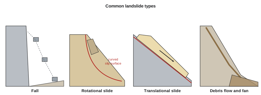
Parts of a landslide
Recognizing landslides in the field and on lidar depends on knowing their features. At the top is the main scarp, a steep surface exposed where the moving mass pulled away; above it, tension cracks may show where the next failure will occur. The head of the slide often contains back-tilted blocks and ponds. The body may be hummocky, with disrupted drainage, springs and seepage. The toe bulges out over the original ground surface and may push into a river channel. Trees growing with curved trunks, tilted fence posts and utility poles, cracked pavements, and broken pipes are all signs of past or present movement. Many large old landslides are dormant but can be reactivated by excavation at the toe, loading at the head, or a rise in groundwater.
Why slopes fail
A slope fails when the shear stress driving movement along some surface exceeds the shear strength available on that surface. Landslides are usually triggered when an event increases the driving stress or decreases the strength.
- Increases in driving stress: steepening of the slope by erosion at the toe or by excavation; loading of the crest by fill, buildings or stockpiles; earthquake shaking.
- Decreases in strength: rising pore water pressure from rainfall, snowmelt, leaking pipes or blocked drainage, which lowers effective stress; weathering and softening of clay and shale; progressive failure as strain concentrates on a slip surface; loss of strength from remoulding of sensitive clays; removal of vegetation and its roots; thawing of ice-rich permafrost.
Water is the most common trigger. Many slope failures follow periods of intense or prolonged rainfall, rapid snowmelt, or both together, and groundwater changes often control the movement rate of slow landslides.
Shear strength and the factor of safety
The shear strength of soil and of rock discontinuities is commonly described by the Mohr–Coulomb criterion in terms of effective stress. The strength \(\tau_f\) on a surface depends on the effective normal stress \(\sigma'\) acting on it, the effective cohesion \(c'\) and the effective friction angle \(\phi'\).
Stability is expressed by a factor of safety, the ratio of available shear strength to the shear stress needed for equilibrium. A factor of safety of 1.0 means the slope is on the point of failure. Design guidelines commonly ask for long-term factors of safety of about 1.3 to 1.5 for permanent slopes, depending on the consequences of failure and the quality of the information, though the required values depend on the owner and jurisdiction.
The infinite slope model
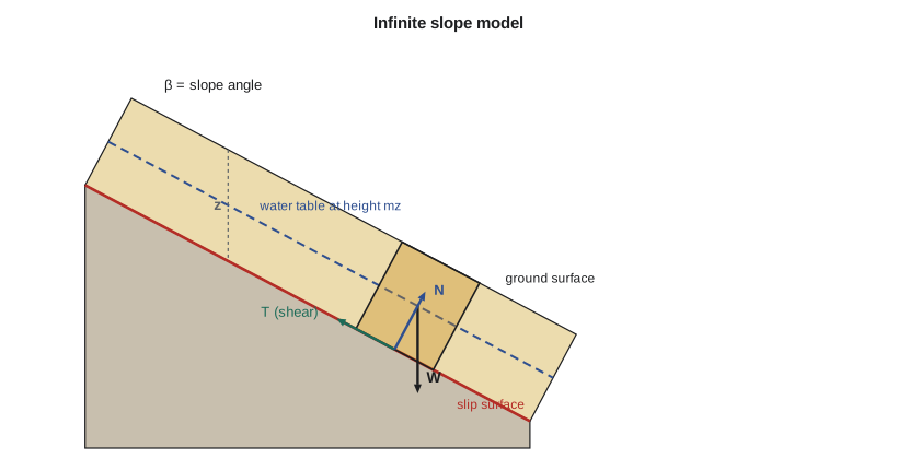
Many shallow landslides move on a slip surface parallel to the ground, at a depth small compared with the length of the slope: a layer of colluvium sliding on rock, or weathered soil over a firmer layer. These can be analysed with the infinite slope model. Consider a slope at angle \(\beta\) with a potential slip surface at vertical depth \(z\), and a water table at a height \(m z\) above the slip surface, with seepage parallel to the slope. Here \(m\) ranges from 0 (dry) to 1 (water table at the surface). The factor of safety is:
For a cohesionless soil with no water (\(c' = 0\), \(m = 0\)), this reduces to \(F = \tan\phi' / \tan\beta\): a dry sand slope stands at any angle up to its friction angle, which is why sand piles form at the angle of repose. With the water table at the ground surface and seepage parallel to the slope, the frictional term is reduced by a factor of roughly one half for typical soils, so a slope that is comfortably stable when dry can fail during wet periods.
Worked problem
Infinite slope analysis of colluvium on the valley wall
Colluvium 3.0 m thick rests on dense till on a 28° slope above the highway alignment. The colluvium has \(\gamma = 19\) kN/m³, \(c' = 4\) kPa and \(\phi' = 32^\circ\). Find the factor of safety (a) with no water table and (b) with the water table at the ground surface and seepage parallel to the slope (\(\gamma_w = 9.81\) kN/m³).
Show solution
- Cohesion term:
- \[\frac{c'}{\gamma z \sin\beta\cos\beta} = \frac{4}{19 \times 3.0 \times 0.4695 \times 0.8829} = \frac{4}{23.63} = 0.169\]
- Friction ratio:
- \[\frac{\tan\phi'}{\tan\beta} = \frac{0.6249}{0.5317} = 1.175\]
- (a) Dry, \(m = 0\):
- \[F = 0.169 + 1.175 = 1.34\]
- (b) Saturated with parallel seepage, \(m = 1\):
- \[F = 0.169 + \Big(1 - \frac{9.81}{19}\Big)(1.175) = 0.169 + 0.484 \times 1.175 = 0.738\]
Answer: The slope has a factor of safety of about 1.34 when dry but only about 0.74 with full saturation, so it would fail in a wet spring. Drainage that keeps the water table low is the key to stabilizing it.
# Infinite slope: factor of safety versus water table height
import math

gamma, gamma_w = 19.0, 9.81      # kN/m3
c, phi = 4.0, math.radians(32)   # kPa, friction angle
z, beta = 3.0, math.radians(28)  # depth m, slope angle

def fs(m):
    coh = c / (gamma * z * math.sin(beta) * math.cos(beta))
    fric = (1 - m * gamma_w / gamma) * math.tan(phi) / math.tan(beta)
    return coh + fric

for m in (0.0, 0.25, 0.5, 0.75, 1.0):
    print(f"m = {m:4.2f} (water table {m*z:.2f} m above slip surface): F = {fs(m):.2f}")

# Highest water table that keeps F >= 1.3
m_allow = max(m / 100 for m in range(0, 101) if fs(m / 100) >= 1.3)
print(f"Water table must stay below about {m_allow*z:.2f} m above the slip surface for F >= 1.3")m = 0.00 (water table 0.00 m above slip surface): F = 1.34 m = 0.25 (water table 0.75 m above slip surface): F = 1.19 m = 0.50 (water table 1.50 m above slip surface): F = 1.04 m = 0.75 (water table 2.25 m above slip surface): F = 0.89 m = 1.00 (water table 3.00 m above slip surface): F = 0.74 Water table must stay below about 0.21 m above the slip surface for F >= 1.3
Rotational slides and limit equilibrium methods
Deeper failures in clay, glacial lake silt and other relatively uniform soils usually take a curved, rotational form. They are analysed by limit equilibrium methods that divide the sliding mass into vertical slices, calculate forces on each, and search many trial slip surfaces for the one with the lowest factor of safety. The ordinary method of slices, Bishop's simplified method, and more rigorous methods such as Morgenstern–Price and Spencer differ in how they handle the forces between slices. Today these analyses are run in software, and finite element methods are used for more complex problems, but the inputs still come from the engineering geology: the geometry of the layers, the strength of each, the groundwater pressures, and any known or suspected slip surfaces. For a reactivated old landslide, the strength on the existing slip surface has usually fallen to its residual value, which in clays can be far below the peak strength measured on intact samples.
Rockfall
Rockfall is the most frequent landslide hazard along mountain roads and railways. Blocks detach from steep faces, often in freeze–thaw seasons or after heavy rain, and bounce and roll down slopes. Engineers estimate rockfall trajectories and energies with simulation software calibrated to the slope profile and surface materials, then design protection: scaling loose rock, rock bolts and dowels, wire mesh draped over the face, catchment ditches at the toe, and flexible barrier fences that can absorb thousands of kilojoules. Rock sheds are built over roads and railways at the worst locations.
Debris flows
Debris flows are fast-moving slurries of water, soil, rock and vegetation that travel down steep channels and spread out on fans at their base. They are triggered by intense rainfall, rapid snowmelt, failure of natural dams, or the collapse of shallow slides into channels, and they are particularly likely in watersheds recently burned by wildfire. Because they move quickly and with great force, debris flows are among the deadliest landslides. Alluvial fans, which are attractive flat building sites in mountain valleys, are often built by repeated debris flows. Hazard assessment uses fan geology, channel history and rainfall data, and mitigation includes avoidance, debris basins, deflection berms and flexible barriers.
Canada has a long record of landslide disasters. The 1903 Frank Slide in Alberta, when part of Turtle Mountain collapsed onto the town of Frank and killed roughly 70 to 90 people, is one of the deadliest rock avalanches in North American history. In British Columbia, debris flows and rockfall regularly close highways, and the November 2021 atmospheric river triggered numerous landslides and debris flows that cut the main highway and rail routes between the coast and the interior for weeks. Sensitive clay landslides in the Ottawa and St. Lawrence valleys, discussed in lesson 6, add a hazard unique to eastern Canada.
Investigating and stabilizing landslides
Investigation of an existing or suspected landslide combines geomorphic mapping from lidar and air photos, field mapping of scarps, cracks and seepage, boreholes with careful logging to locate weak layers, and instrumentation. Inclinometers, casings grouted into boreholes and measured with a probe, show the depth and rate of movement; piezometers record pore pressures; surface survey, GNSS and satellite radar interferometry track displacement over wide areas. Together these define the depth and shape of the slip surface and the relationship between groundwater and movement, which are essential for design.
Stabilization methods fall into a few groups. Drainage, by horizontal drains drilled into the slope, trench drains, wells or drainage tunnels, lowers pore pressures and is often the most cost-effective measure. Geometry changes unload the head of a slide or add a buttress at the toe. Structural measures include retaining walls, piles or shafts across the slip surface, and anchors. Surface protection, erosion control and vegetation reduce infiltration and shallow sliding. For the highway realignment, Kestrel recommended horizontal drains to lower the water table in the slide mass and a rockfill buttress at the toe, with inclinometers and piezometers to confirm performance.
Common mistakes
MistakeUsing peak strength for a reactivated landslide.
InsteadMovement has reduced strength on the slip surface toward residual values; use residual strength from tests or back-analysis.
MistakeAssuming a slope stable in summer will be stable in spring.
InsteadRising groundwater in wet seasons can halve the frictional resistance; analyse the worst credible water conditions.
MistakeExcavating at the toe of an old landslide for a road widening.
InsteadRemoving toe support can reactivate a dormant slide; map and investigate old landslides before cutting.
MistakeTreating an alluvial fan as a safe flat site.
InsteadMany fans are built by debris flows; assess the fan's history and the catchment before building.
Summary and key terms
- Landslides are classified by movement type (fall, topple, slide, spread, flow) and material (rock, debris, earth).
- Slopes fail when driving shear stress exceeds shear strength; water is the most common trigger.
- Shear strength follows Mohr–Coulomb in terms of effective stress; the factor of safety is strength divided by required stress.
- The infinite slope model shows that a rising water table can drastically reduce stability of shallow slides.
- Deeper slides are analysed with limit equilibrium methods; reactivated slides have strength near residual.
- Investigation uses lidar, mapping, boreholes and instruments; stabilization relies mainly on drainage, geometry changes and structures.
- Landslide
- The downslope movement of rock, soil or debris under gravity.
- Rotational slide
- A slide on a curved, concave-upward slip surface.
- Translational slide
- A slide on a roughly planar surface.
- Debris flow
- A rapid, channelized flow of saturated debris.
- Factor of safety
- The ratio of available shear strength to the shear stress required for equilibrium.
- Residual strength
- The low shear strength of a clay after large displacement on a slip surface.
- Inclinometer
- An instrument in a borehole casing that measures lateral ground movement with depth.
- Main scarp
- The steep surface at the head of a landslide exposed by movement.
Practice problems
Work each problem on paper first, then reveal the answer to check.
A dry cohesionless sand slope has \(\phi' = 34^\circ\). What is the maximum slope angle for \(F = 1.0\)? For \(F = 1.3\)?
Show answer
\(34^\circ\); for \(F = 1.3\), \(\tan\beta = \tan 34^\circ/1.3 = 0.519\), so \(\beta = 27.4^\circ\).
Why are spring snowmelt periods common times for landslides?
Show answer
Infiltration raises groundwater and pore pressures, reducing effective stress and strength.
Name three signs of slope movement visible in the field.
Show answer
Tension cracks and scarps, tilted trees and poles, hummocky ground with springs and disrupted drainage, cracked pavement.
What does an inclinometer measure?
Show answer
Lateral displacement with depth, revealing the depth and rate of movement on the slip surface.
Give two ways of stabilizing a landslide.
Show answer
Drainage (horizontal drains, wells) and a toe buttress; also unloading the head, piles or anchors.
In the infinite slope equation, what does \(m\) represent?
Show answer
The height of the water table above the slip surface as a fraction of the slip depth.
Lesson quiz · 5 questions
Score 60% or more to complete this lesson.
Create a free account to save your progress, take quizzes and earn a certificate.