
CIV-241 · Lesson 6 of 12 · 22 min
Glacial and surficial deposits
At the peak of the last glaciation, roughly 20,000 years ago, ice sheets up to several kilometres thick covered almost all of Canada. The Laurentide Ice Sheet spread over the interior and east, and the Cordilleran Ice Sheet filled the mountains and valleys of British Columbia. As the ice melted back between about 18,000 and 8,000 years ago, it left a complex blanket of deposits: till plastered beneath the ice, gravel and sand washed out by meltwater, silt and clay settled in glacial lakes and seas, and later river, wind and slope deposits on top. These Quaternary deposits are the ground on which most Canadian infrastructure is built, and their variety explains a large share of the country's geotechnical problems.
How glaciers erode and deposit
Glaciers erode by plucking blocks from the bed and by abrasion as rock fragments embedded in the ice scrape the surface beneath. In mountains, valley glaciers carve U-shaped valleys with steep walls and flat floors, deepen basins that later fill with sediment, and leave hanging tributary valleys. On the plains, ice sheets scour bedrock into smoothed, striated surfaces and pick up enormous quantities of debris, much of it crushed to silt- and clay-sized rock flour.
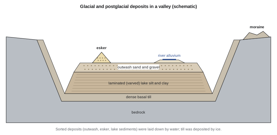
Glacial sediments are divided into two broad groups. Till is deposited directly by ice and is unsorted. Glaciofluvial and glaciolacustrine sediments are deposited by meltwater and are sorted by grain size, because flowing water carries fine particles farther than coarse ones and drops them as it slows. This single distinction, unsorted versus sorted, goes a long way toward predicting engineering properties.
Till
Till is an unsorted mixture of everything from clay to boulders, deposited beneath or at the margin of the ice. Its matrix may be sandy, silty or clayey depending on the rocks the ice crossed. Basal or lodgement till was plastered onto the bed beneath moving ice under great pressure and is typically very dense or hard, with low compressibility and high strength; it is often an excellent foundation stratum. Ablation till, let down from melting ice, is looser and more variable. Till sheets can contain lenses of sorted sand and gravel, which carry water and may flow into excavations, and boulders, which obstruct piles, sheet piles, tunnel boring machines and horizontal drilling.
Dense lodgement till often behaves as an overconsolidated soil: its preconsolidation pressure reflects the weight of ice that once stood on it. It has high undrained strength and low permeability, but it may be fissured, and when excavated slopes in fissured clay till are exposed over the long term, they can lose strength and fail at angles that seemed stable during construction.
Moraines and drumlins
Moraines are ridges of till and other debris built at the edge of the ice. End or terminal moraines mark the furthest advance of a glacier or a pause during retreat; lateral moraines form along valley sides. Moraines are often hummocky and very variable, with buried ice blocks that melted later to form kettle hole ponds. Drumlins are streamlined, elongated hills of till shaped beneath moving ice, with their long axes parallel to the ice flow direction; they are common in parts of Ontario, Nova Scotia, New York and Wisconsin.
Glaciofluvial deposits: outwash, eskers and kames
Meltwater flowing from the ice carried sand and gravel and spread it out as outwash plains and valley trains in front of the glacier. Within and beneath the ice, meltwater streams deposited eskers, long winding ridges of sand and gravel that mark former tunnels in the ice. Kames are mounds of sorted sediment deposited against or in openings in the ice. All of these deposits are layered and sorted, with rounded particles, and they are typically permeable and free-draining.
For engineers, glaciofluvial deposits are mainly a resource and a groundwater issue. Eskers and outwash plains are the main sources of natural sand and gravel for concrete aggregate, road base and fill across much of the north. They are also the best shallow aquifers, which brings conflicts between aggregate extraction and groundwater protection, and they transmit large volumes of water into excavations, requiring dewatering. Their density varies: outwash is usually medium dense to dense, but loose layers occur and can be susceptible to liquefaction in earthquakes.
Glaciolacustrine and glaciomarine deposits
As the ice retreated, meltwater was often trapped between the ice front and higher ground, forming large proglacial lakes. Fine silt and clay settled out on the lake floors, often in rhythmic layers called varves: a coarser, lighter silt layer deposited in summer when meltwater flow was high and a thin, darker clay layer deposited in winter under ice when the water was still. A pair of layers represents one year, so counting varves gives the duration of a lake.
Glaciolacustrine clays and silts are often soft, compressible and weak, especially near the surface where they have not been overconsolidated. They cause large consolidation settlements under embankments and buildings, and their layered structure gives them much higher horizontal than vertical permeability. Silt layers can be very sensitive to disturbance and may become quick when vibrated or excavated below the water table.
Glacial Lake Agassiz, which covered much of Manitoba, Saskatchewan, northwestern Ontario and North Dakota and Minnesota, left thick, highly plastic clays beneath Winnipeg and the Red River valley. These clays shrink, swell and creep, and riverbank landslides are common along the Red and Assiniboine rivers. In the Ottawa and St. Lawrence valleys, the land was depressed by the weight of ice, and the sea flooded in as the Champlain Sea. Clays and silts deposited in this salt water became the sensitive Leda clay, whose salt has since been leached by fresh groundwater. Leda clay can lose almost all of its strength when disturbed and flow like a liquid. It has produced devastating retrogressive landslides, such as the 1993 Lemieux landslide in eastern Ontario and the 2010 Saint-Jude landslide in Quebec, which killed a family of four. Around Kamloops, glacial lakes dammed in the valleys left thick terraces of silt that are prone to erosion, piping and landslides on the valley walls, which is the setting of the highway realignment in this course.
Postglacial deposits
After the ice left, rivers, wind, slopes and organic growth continued to add to the ground.
- Alluvium: rivers deposit gravel and sand in channels and finer silt and clay on floodplains during floods. River deposits are laterally variable, with abandoned channel fills of soft clay or organic material cutting through coarser deposits. Bridge piers, levees and embankments on floodplains must account for this variability and for scour.
- Loess: wind-blown silt picked up from outwash plains and dry lake beds forms blankets of loess, common in the Palouse region of Washington and Idaho, the Mississippi valley and parts of the Canadian prairies. Loess stands in near-vertical cuts when dry but can collapse suddenly when wetted under load, a behaviour called hydrocollapse.
- Dune sand: uniform, fine sand, loose and easily eroded.
- Peat and organic soils: bogs and fens accumulated in kettle holes, poorly drained depressions and the northern lowlands. Peat is extremely compressible, has water contents of several hundred per cent, and creeps for decades. In Canada, large areas of muskeg complicate road and pipeline construction.
- Colluvium and talus: debris accumulated at the foot of slopes, often loose, unstable and seasonally wet.
Grain size distribution and sorting
Grain size distribution is the most basic way to tell glacial deposits apart. It is determined by sieving the coarse fraction and by a sedimentation (hydrometer) test for the fines, and plotted as per cent passing against particle size on a logarithmic scale. Two coefficients summarize the shape of the curve: the coefficient of uniformity \(C_u\) and the coefficient of curvature \(C_c\).
Here \(D_{10}\), \(D_{30}\) and \(D_{60}\) are the particle sizes at which 10, 30 and 60 per cent of the soil by mass is finer. A well-graded gravel has \(C_u \ge 4\) and a well-graded sand \(C_u \ge 6\), in both cases with \(1 \le C_c \le 3\); soils that do not meet these limits are poorly graded. Till typically plots as a long, flat curve spanning clay to gravel, with a very high \(C_u\), while outwash sand and glaciolacustrine silt plot as steeper curves over narrower size ranges. \(D_{10}\) is also used in Hazen's rough estimate of hydraulic conductivity for clean sands, which we use in lesson 8.
Worked problem
Classifying outwash and till by gradation
Two samples from the reservoir site have these characteristic sizes. Sample A: \(D_{10} = 0.25\) mm, \(D_{30} = 0.42\) mm, \(D_{60} = 0.70\) mm. Sample B: \(D_{10} = 0.004\) mm, \(D_{30} = 0.06\) mm, \(D_{60} = 0.9\) mm. Compute \(C_u\) and \(C_c\) and suggest the likely origin of each.
Show solution
- Sample A:
- \[C_u = \frac{0.70}{0.25} = 2.8 \qquad C_c = \frac{0.42^{2}}{0.25 \times 0.70} = 1.01\]
- A low \(C_u\) means the sand is uniformly (poorly) graded, typical of water-sorted outwash or lake-shore sand.
- Sample B:
- \[C_u = \frac{0.9}{0.004} = 225 \qquad C_c = \frac{0.06^{2}}{0.004 \times 0.9} = 1.0\]
- An extremely high \(C_u\) spanning clay to coarse sand indicates an unsorted deposit, most likely till.
Answer: Sample A is a poorly graded sand (\(C_u\) about 2.8), probably outwash; sample B has \(C_u\) about 225 and is an unsorted till.
# Gradation coefficients from sieve and hydrometer data (log interpolation)
import math

def d_at(percent, sizes, passing):
    # sizes in mm (descending), passing in % (descending)
    for (d1, p1), (d2, p2) in zip(zip(sizes, passing), zip(sizes[1:], passing[1:])):
        if p2 <= percent <= p1:
            f = (percent - p2) / (p1 - p2)
            return 10 ** (math.log10(d2) + f * (math.log10(d1) - math.log10(d2)))
    return None

samples = {
    "outwash sand": ([4.75, 2.0, 0.85, 0.425, 0.25, 0.15, 0.075], [100, 98, 75, 30, 10, 3, 1]),
    "till":         ([19, 4.75, 2.0, 0.425, 0.075, 0.02, 0.005, 0.002], [100, 82, 70, 52, 34, 22, 11, 7]),
}
for name, (sizes, passing) in samples.items():
    d10, d30, d60 = (d_at(p, sizes, passing) for p in (10, 30, 60))
    cu = d60 / d10
    cc = d30 ** 2 / (d10 * d60)
print(f"{name:12s} D10={d10:.4f} D30={d30:.3f} D60={d60:.3f} mm Cu={cu:6.1f} Cc={cc:4.2f}")outwash sand D10=0.2500 D30=0.425 D60=0.675 mm Cu= 2.7 Cc=1.07 till D10=0.0040 D30=0.048 D60=0.846 mm Cu= 212.7 Cc=0.69
Reading glacial landforms in the field and on lidar
Many glacial deposits can be recognized from their landforms before any borehole is drilled, which makes air photos, lidar and topographic maps essential parts of a desk study. Hummocky terrain with small closed depressions usually means stagnant-ice moraine with variable till and buried sand bodies. Smooth, streamlined hills aligned in one direction are drumlins of dense till. Flat terraces along valley sides often record former lake levels or outwash surfaces; their fronts may expose silt or gravel and are common sites of erosion and sliding. Sinuous ridges crossing the landscape are eskers, and gravel pits along them confirm the interpretation. Flat, poorly drained plains with organic soils indicate former lake beds or bogs where soft clay and peat should be expected.
Lidar, which maps the bare ground surface beneath vegetation, has transformed this work. On the highway project, lidar revealed the arcuate headscarp and hummocky toe of the old landslide through dense forest, features that were invisible on air photos and had been missed by the original road builders. A geologist who can read these landforms can place boreholes where they will test the model rather than at regular intervals that may miss the critical feature entirely.
Isostatic rebound and other legacies of glaciation
The weight of the ice sheets pushed the crust down by hundreds of metres. Since the ice melted, the land has been slowly rising, a process called glacial isostatic adjustment. Uplift is still around a centimetre per year near Hudson Bay, while areas around the former ice margin are slowly sinking. The effect matters for long-term tide gauge and survey benchmarks, for the gradients of long canals and drainage systems, and for relative sea level along coasts.
Glaciation also left buried valleys: deep bedrock channels carved by ice or meltwater and later filled with sediment. A borehole line can easily miss a buried valley, and a tunnel or deep foundation that unexpectedly enters one can encounter soft, saturated soils under high water pressure. Regional mapping of buried valleys by provincial and state geological surveys is an important part of a desk study.
Common mistakes
MistakeAssuming till is always a good foundation.
InsteadLodgement till is usually dense, but ablation till is loose, and till can contain water-bearing sand lenses and boulders.
MistakeTreating varved clays as uniform.
InsteadTheir layering gives higher horizontal permeability and can include sensitive silt layers; sample and test carefully.
MistakeIgnoring the possibility of sensitive marine clay in former marine basins.
InsteadCheck maps of postglacial marine limits; sensitive clays can lose most of their strength when disturbed.
MistakeExpecting a uniform floodplain beneath a bridge.
InsteadRiver deposits vary laterally with abandoned channels of soft clay and organics; investigate each pier.
Summary and key terms
- Most northern infrastructure is built on Quaternary deposits left by the last ice sheets.
- Till is unsorted and deposited by ice; lodgement till is dense and strong but may contain boulders and sand lenses.
- Glaciofluvial deposits (outwash, eskers, kames) are sorted, permeable sand and gravel: valuable aggregate and aquifers.
- Glaciolacustrine and glaciomarine clays are often soft, compressible and layered; leached marine clays can be extremely sensitive.
- Postglacial alluvium, loess, peat and colluvium add further variability.
- Grain size distribution and the coefficients \(C_u\) and \(C_c\) distinguish sorted from unsorted deposits.
- Till
- Unsorted sediment deposited directly by glacier ice.
- Moraine
- A ridge of till and debris deposited at the margin of a glacier.
- Outwash
- Sorted sand and gravel deposited by meltwater streams in front of a glacier.
- Esker
- A winding ridge of sand and gravel deposited by a meltwater stream within or beneath the ice.
- Varve
- A pair of annual layers, coarse summer silt and fine winter clay, deposited in a glacial lake.
- Sensitive clay
- A clay that loses most of its strength when remoulded.
- Loess
- Wind-blown silt that can collapse when wetted under load.
- Coefficient of uniformity
- The ratio \(D_{60}/D_{10}\), describing the range of particle sizes.
Practice problems
Work each problem on paper first, then reveal the answer to check.
Why is lodgement till usually dense and strong?
Show answer
It was compacted beneath thick moving ice, so it is heavily overconsolidated.
What distinguishes outwash from till?
Show answer
Outwash is sorted and layered by meltwater; till is unsorted and deposited directly by ice.
A sand has \(D_{10} = 0.15\) mm, \(D_{30} = 0.35\) mm, \(D_{60} = 1.2\) mm. Is it well graded?
Show answer
\(C_u = 8\), \(C_c = 0.68\); \(C_c\) is below 1, so it is poorly graded despite the high \(C_u\).
What is a varve?
Show answer
A pair of layers representing one year in a glacial lake: summer silt and winter clay.
Why can loess cause foundation problems?
Show answer
It can collapse suddenly when wetted under load (hydrocollapse).
What is glacial isostatic adjustment?
Show answer
The slow rise of land that was depressed by the weight of ice sheets.
Lesson quiz · 5 questions
Score 60% or more to complete this lesson.
Create a free account to save your progress, take quizzes and earn a certificate.