
CIV-241 · Lesson 11 of 12 · 21 min
Karst, subsidence, permafrost and other hazards
Landslides and earthquakes are the most dramatic geologic hazards, but many others quietly damage infrastructure and cost far more in total. Ground can collapse into hidden cavities, sink as fluids are pumped out or old mines cave in, heave as frost or swelling clays push upward, or soften as frozen ground thaws. These hazards share a pattern: they often give little visible warning on the surface, they depend on geological conditions that can be mapped and investigated, and they are far cheaper to deal with by recognition and avoidance than by repair. This lesson surveys the most important ones for North American practice.
Karst
Karst is the landscape and subsurface drainage system that develops where soluble rocks, mainly limestone, dolostone, gypsum and salt, are dissolved by groundwater. Rainwater absorbs carbon dioxide from the air and soil to form weak carbonic acid, which slowly dissolves calcite along joints and bedding planes. Over thousands of years the openings enlarge into fissures, conduits and caves. At the surface, karst produces sinkholes, disappearing streams, large springs and an irregular, pinnacled rock surface buried beneath soil.
Sinkholes are the main engineering hazard. Dissolution sinkholes form slowly as the rock surface is lowered. Cover-collapse sinkholes form when soil above a cavity or widened fissure ravels down into it, creating a void in the soil that grows upward until the roof collapses suddenly, sometimes overnight. Cover-subsidence sinkholes form more gradually where sandy cover slowly trickles into openings below. Human activities often trigger sinkholes: concentrated drainage from roofs, roads and leaking pipes washes soil into openings, and pumping groundwater lowers the water table and removes buoyant support from soil arches.
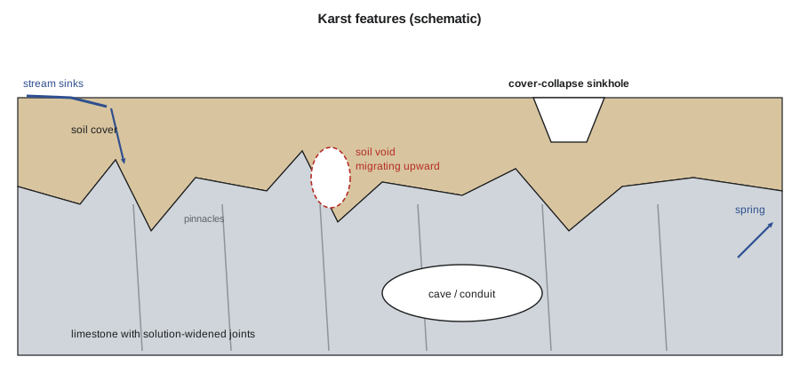
Karst complicates foundations because the rock surface can vary by many metres between closely spaced points, and borings that hit sound rock may sit on a pinnacle beside a soil-filled slot. Investigation uses closely spaced probes and borings, geophysics such as electrical resistivity tomography and ground-penetrating radar to find voids, and careful attention to drainage. Mitigation includes avoiding sinkholes, controlling surface water, grouting voids, bridging over them with reinforced mats or beams, and founding on piles or drilled shafts socketed into sound rock after probing beneath each one.
Karst occurs in several parts of Canada, including the limestones and dolostones of southern Ontario and the Niagara Escarpment, parts of Manitoba, the Rocky Mountains and Nova Scotia, where gypsum karst is common. Gypsum dissolves much faster than limestone, and sinkholes in gypsum near Wood Buffalo National Park and in Nova Scotia can form within human time scales.
Subsidence
Subsidence is the gradual or sudden sinking of the ground surface. Apart from karst, the main causes are:
- Fluid withdrawal: pumping groundwater, oil or gas from compressible sediments reduces pore pressure and increases effective stress, so clay layers consolidate. Regional subsidence from groundwater pumping has exceeded several metres in California's San Joaquin Valley, around Houston and Galveston, and in Mexico City. It damages wells, canals, pipelines and drainage, increases flooding in low-lying areas and is largely irreversible.
- Underground mining: collapse of old coal, salt and metal mines produces sudden pit-type sinkholes over shallow workings and broad troughs over longwall panels. Abandoned mines are common in coal regions of Nova Scotia, Alberta, Pennsylvania and the Appalachians, and in old metal-mining towns. Mine records are often incomplete, so investigation may need drilling and geophysics.
- Dissolution of salt, either naturally or through solution mining.
- Drainage of organic soils: peat that is drained shrinks and oxidizes, lowering the land surface by centimetres per year.
- Hydrocompaction: dry, loose soils such as loess and some alluvial fan deposits collapse when wetted for the first time, as discussed in lesson 6.
Subsidence from groundwater withdrawal can be estimated with one-dimensional consolidation theory. When the head in an aquifer falls by \(\Delta h\), the effective stress in the confining clay layers rises by about \(\gamma_w \Delta h\) once the clay has drained, and the clay compresses accordingly. For a normally consolidated clay, the settlement is approximately:
where \(C_c\) is the compression index, \(H\) the clay thickness, \(e_0\) the initial void ratio and \(\sigma'_0\) the initial vertical effective stress at the middle of the layer. Overconsolidated clays compress much less until their preconsolidation pressure is exceeded.
Worked problem
Settlement from lowering the head in an aquifer
Pumping from the new well field will lower the head in the confined gravel aquifer by 4.0 m near the wells. Above the aquifer is a 6.0 m layer of normally consolidated glacial lake clay with \(C_c = 0.35\), \(e_0 = 1.10\), and an initial effective stress at mid-depth of 85 kPa. Estimate the long-term settlement of the clay.
Show solution
- Once the clay has drained, the pore pressure at its base falls by \(\gamma_w \Delta h\) and the average increase in effective stress in the layer is about half of that if the head at its top does not change:
- \[\Delta\sigma' \approx \tfrac{1}{2}(9.81)(4.0) = 19.6\ \text{kPa}\]
- Settlement of the normally consolidated clay:
- \[s = \frac{0.35 \times 6.0}{1 + 1.10} \log_{10}\frac{85 + 19.6}{85} = 1.0 \times 0.0904 = 0.090\ \text{m}\]
Answer: About 90 mm of long-term settlement near the wells, decreasing with distance. This is enough to affect sensitive structures and buried pipes, so Kestrel recommended monitoring benchmarks and limiting drawdown near existing buildings.
Frost action
In cold climates, seasonal freezing of the ground causes frost heave. Heave is not simply the 9 per cent expansion of pore water; it is mainly caused by ice lenses that grow as water is drawn upward by suction to the freezing front, especially in silts and fine sands that combine high capillarity with moderate permeability. Heave lifts shallow footings, pavements, retaining walls and utilities, and the following thaw leaves the soil weakened and saturated, causing pavement breakup in spring. Frost susceptibility is assessed mainly by grain size, particularly the percentage finer than 0.02 mm, and by soil type.
Design responses include placing footings below the design frost depth, using non-frost-susceptible granular materials beneath pavements and slabs, providing drainage to keep water away from the freezing zone, and using rigid insulation to reduce frost penetration. Design frost depths vary from less than a metre in mild coastal areas to more than two metres in the northern interior, and are given in local codes and practice.
Permafrost
Permafrost is ground that remains at or below 0 °C for at least two consecutive years. It underlies large areas of northern Canada, Alaska and other polar and mountain regions. Above the permafrost is the active layer, which thaws each summer and refreezes each winter. Permafrost that contains little ice, such as dense gravel or sound rock, is thaw-stable: it loses little strength or volume on thawing. Permafrost in fine soils often contains large volumes of excess ice in lenses and wedges, and is thaw-unstable: when it thaws, the ice melts, the ground settles and the soil may turn to mud.
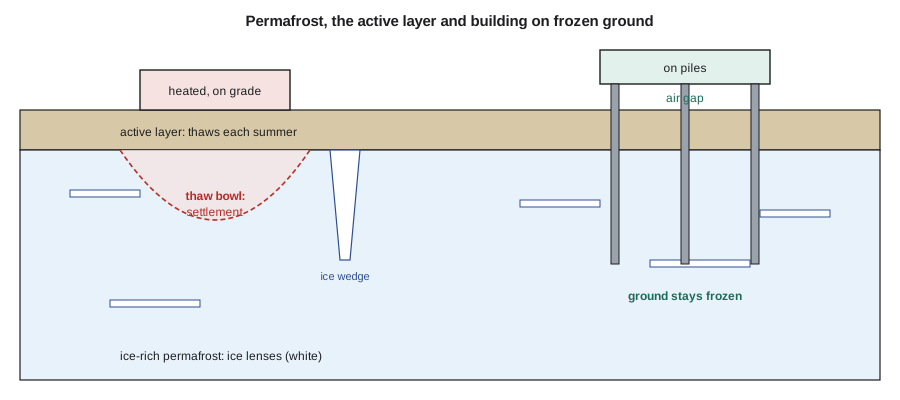
Construction disturbs the thermal balance. Removing the insulating vegetation and organic layer, placing dark pavements, and building heated structures directly on the ground all cause thawing and settlement. Northern engineering therefore follows two strategies: keeping the ground frozen, by building on piles with ventilated air spaces, using insulated and ventilated pads, and installing thermosyphons that remove heat from the ground in winter; or, where the ground is thaw-stable or thin, removing or pre-thawing the permafrost before building. Climate warming is degrading permafrost across the north, threatening existing roads, airstrips, pipelines and buildings, and making thaw settlement and thaw-related landslides more common.
The settlement caused by thawing ice-rich permafrost can be estimated from the thaw strain, the fractional reduction in thickness when a layer thaws and drains. If a layer of thickness \(H\) has thaw strain \(\varepsilon_t\), the thaw settlement is roughly \(s = \varepsilon_t H\), plus any further consolidation under load. Thaw strains of 10 to 30 per cent are common in ice-rich silts, so even a few metres of thaw can cause large settlement.
# Subsidence estimates: aquifer drawdown (consolidation) and permafrost thaw
import math

# Consolidation of a clay layer from aquifer drawdown
Cc, e0, H, sig0, gw = 0.35, 1.10, 6.0, 85.0, 9.81
for dh in (2.0, 4.0, 8.0):
    dsig = 0.5 * gw * dh
    s = Cc * H / (1 + e0) * math.log10((sig0 + dsig) / sig0)
    print(f"head drop {dh:3.0f} m -> about {s*1000:4.0f} mm settlement")

# Thaw settlement of ice-rich permafrost layers: (thickness m, thaw strain)
profile = [(1.0, 0.05), (2.0, 0.25), (1.5, 0.15), (3.0, 0.03)]
depth = 0.0
for thaw_depth in (1.0, 3.0, 4.5, 7.5):
    s = 0.0
    top = 0.0
    for h, eps in profile:
        thawed = max(0.0, min(h, thaw_depth - top))
        s += eps * thawed
        top += h
print(f"thaw to {thaw_depth:3.1f} m below the active layer -> about {s:.2f} m settlement")head drop 2 m -> about 47 mm settlement head drop 4 m -> about 90 mm settlement head drop 8 m -> about 165 mm settlement thaw to 1.0 m below the active layer -> about 0.05 m settlement thaw to 3.0 m below the active layer -> about 0.55 m settlement thaw to 4.5 m below the active layer -> about 0.78 m settlement thaw to 7.5 m below the active layer -> about 0.86 m settlement
Expansive and collapsible soils
Expansive soils rich in smectite, introduced in lesson 2, swell when they absorb water and shrink when they dry. They damage light structures such as houses, slabs and pavements through differential heave and through seasonal cycles, especially where trees, leaking pipes or poor drainage cause uneven moisture changes. Their potential is assessed from plasticity, clay content, swell tests and suction measurements. Mitigation includes deep foundations or stiffened slabs, moisture control around buildings, removal and replacement of the active zone, and chemical stabilization with lime. Collapsible soils, such as loess and some fan deposits, have the opposite problem, losing volume suddenly when wetted under load.
Other hazards worth recognizing
- Flooding and erosion: floodplains, alluvial fans and coastlines are dynamic. Rivers migrate laterally, erode banks and scour around bridge piers; coastal bluffs retreat; and floods deposit sediment and debris. Geological mapping of floodplain and channel history complements hydrological flood mapping.
- Volcanic hazards: in the Cascades and Alaska, lahars (volcanic mudflows) travelling down river valleys are the greatest threat to communities far from the volcanoes themselves, as shown by the 1980 Mount St. Helens eruption. Volcanic ash also affects infrastructure over large areas.
- Radon and naturally occurring hazardous materials: some granites, shales and uranium-bearing rocks release radon gas into buildings; serpentinites can contain asbestos; and some rocks release metals or acid drainage when excavated.
- Methane and other gases from buried organic deposits, old landfills or coal can accumulate in excavations, tunnels and basements.
| Hazard | Geological setting | Key investigation methods | Typical mitigation |
|---|---|---|---|
| Karst sinkholes | Limestone, dolostone, gypsum, salt | Probing, closely spaced borings, resistivity, GPR | Avoid, control drainage, grout, bridge, pile to rock |
| Subsidence from pumping | Compressible clays over aquifers | Piezometers, consolidation tests, survey and InSAR | Limit drawdown, recharge, monitor |
| Mine subsidence | Old coal, salt and metal mines | Mine records, drilling, geophysics | Grout voids, avoid, design for movement |
| Frost heave | Silts and fine sands in cold climates | Grain size, frost depth records | Footings below frost, granular fill, insulation, drainage |
| Permafrost thaw | Ice-rich fine soils in the north | Drilling with ice description, ground temperature | Keep frozen (piles, pads, thermosyphons) or remove |
| Expansive soils | Smectite-rich clays and shales | Plasticity, swell tests, suction | Deep foundations, stiff slabs, moisture control, lime |
| Collapsible soils | Loess, dry fan deposits | Collapse tests | Prewetting, compaction, deep foundations |
Common mistakes
MistakeFounding on a single rock pinnacle in karst because the borehole hit rock.
InsteadProbe beneath each footing or pile and expect slots and voids between pinnacles.
MistakeDischarging roof and road drainage into the ground in karst.
InsteadConcentrated infiltration washes soil into openings and triggers sinkholes; collect and route water away.
MistakePlacing a heated building directly on ice-rich permafrost.
InsteadKeep the ground frozen with piles and an air gap, ventilated pads or thermosyphons.
MistakeAssuming groundwater pumping has no effect on nearby structures.
InsteadDrawdown increases effective stress in compressible layers; estimate consolidation settlement and monitor.
Summary and key terms
- Karst forms by dissolution of carbonate and evaporite rocks; cover-collapse sinkholes can form suddenly, often triggered by drainage or pumping.
- Subsidence results from fluid withdrawal, mining, salt dissolution, peat drainage and hydrocompaction.
- Consolidation theory estimates settlement from groundwater drawdown in compressible clays.
- Frost heave is caused by ice lens growth in frost-susceptible silts and fine sands.
- Thaw-unstable permafrost settles and weakens when it thaws; northern design keeps it frozen or removes it.
- Expansive and collapsible soils, flooding, volcanic, radon and gas hazards also need recognition.
- Karst
- Terrain and drainage formed by dissolution of soluble rocks.
- Cover-collapse sinkhole
- A sinkhole formed by sudden collapse of soil arching over a void.
- Subsidence
- Sinking of the ground surface.
- Frost heave
- Upward movement of the ground caused by the growth of ice lenses during freezing.
- Permafrost
- Ground that stays at or below 0 °C for at least two consecutive years.
- Active layer
- The surface layer above permafrost that thaws and refreezes each year.
- Thermosyphon
- A passive heat pipe that removes heat from the ground in winter to keep it frozen.
- Thaw strain
- The fractional decrease in thickness of frozen soil when it thaws and drains.
Practice problems
Work each problem on paper first, then reveal the answer to check.
Why do cover-collapse sinkholes often appear without warning?
Show answer
The void grows upward in the soil out of sight, and the remaining arch collapses suddenly.
Name two human activities that commonly trigger sinkholes.
Show answer
Concentrated drainage into the ground and groundwater pumping (also leaking pipes and excavation).
A 3 m ice-rich layer has a thaw strain of 0.20. Estimate its thaw settlement.
Show answer
\(0.20 \times 3 = 0.6\) m.
Which soils are most frost-susceptible?
Show answer
Silts and fine sands with high capillarity and moderate permeability.
What is a thermosyphon used for?
Show answer
Removing heat from the ground in winter to keep permafrost frozen beneath structures.
Why is subsidence from groundwater pumping largely irreversible?
Show answer
Clay layers consolidate plastically and do not rebound significantly when heads recover.
Lesson quiz · 5 questions
Score 60% or more to complete this lesson.
Create a free account to save your progress, take quizzes and earn a certificate.