
CIV-241 · Lesson 1 of 12 · 24 min
Engineering geology and the dynamic Earth
Every civil engineering project sits on, in or against the ground. A highway cut exposes rock that may slide along a clay-filled joint; a hospital foundation transmits its load into glacial till or soft lake clay; a dam holds back water that will try to find a path through fractured bedrock. Engineering geology is the discipline that reads the ground for engineers. It asks what materials are present, how they got there, how they vary from place to place, and how they will behave when we load them, excavate them or change the water in them. This course gives you the geological literacy a civil engineer needs to talk with geologists and geotechnical engineers, to read their reports critically, and to recognize when a site is more complicated than the drawings suggest.
Throughout the course we follow one consulting firm. Kestrel Geoscience is a small engineering geology and geotechnical practice in Kamloops, British Columbia, a city set in a glaciated valley where the North and South Thompson rivers meet. This year the firm has three main assignments: a provincial highway realignment that must cross an old landslide on a valley wall; the site investigation for a regional hospital expansion, where the seismic site class will drive the structural design; and a new municipal water reservoir and well field on the valley floor. The principal is Dr. Ingrid Halvorsen, P.Geo., P.Eng. Marcus Bell, an engineer-in-training, logs boreholes and writes the field reports, and Priya Nair, a co-op student, writes short Python programs to check calculations and organize data.
What engineering geology is for
Geology as a science explains the history of the Earth. Engineering geology borrows that knowledge for a practical purpose: predicting ground conditions and ground behaviour at a particular site, for a particular project, over the project's design life. The engineering geologist's main products are a ground model and an assessment of geologic hazards. The ground model is a three-dimensional picture of the materials beneath the site, their boundaries and their properties, together with the groundwater conditions. The hazard assessment asks which natural processes, such as landslides, earthquakes, flooding, erosion, subsidence or frost action, could affect the project and how likely and severe they are.
Most failures of civil works that involve the ground are not caused by exotic theory being wrong. They are caused by ground conditions that nobody anticipated: a buried channel full of soft clay between two boreholes that both hit gravel, a weak layer of bentonite in a shale sequence, an old landslide that was mistaken for a natural terrace, or a perched water table that flooded an excavation. Geological thinking reduces that risk because it explains why a deposit is where it is, and therefore what is likely to lie between the points that were actually tested.
The Earth's internal structure
The Earth has a layered structure that formed as dense materials sank and lighter materials rose early in its history. At the centre is a solid inner core and a liquid outer core, both mostly iron and nickel. Around the core is the mantle, nearly 2,900 km thick, made of dense silicate rock that is solid on short time scales but flows very slowly over millions of years. On top is the crust, a thin skin only about 5 to 10 km thick beneath the oceans and typically 30 to 50 km thick beneath the continents, and thicker under major mountain ranges.
For plate tectonics, a mechanical division matters more than a chemical one. The lithosphere is the rigid outer shell made of the crust plus the uppermost mantle, roughly 100 km thick on average. It rests on the asthenosphere, a hotter, weaker zone of the mantle that can deform slowly. The lithosphere is broken into a dozen or so large plates and many smaller ones that move relative to one another at a few centimetres per year, roughly the speed at which fingernails grow.
| Layer | Approximate thickness or depth | Main materials | Engineering relevance |
|---|---|---|---|
| Continental crust | 30–50 km thick | Granitic and metamorphic rocks with sedimentary cover | All construction takes place in the top few hundred metres |
| Oceanic crust | 5–10 km thick | Basalt and gabbro | Forms sea floor; subducts at ocean trenches |
| Lithospheric mantle | To about 100 km depth | Peridotite (olivine-rich rock) | Part of the rigid plates |
| Asthenosphere | About 100–350 km depth | Hot, weak peridotite | Allows plates to move |
| Lower mantle | To about 2,900 km depth | Dense silicates | Drives slow convection |
| Outer and inner core | 2,900–6,370 km depth | Iron–nickel alloy | Generates the magnetic field |
Plate tectonics and plate boundaries
Plate tectonics is the unifying theory of geology. It explains the distribution of earthquakes, volcanoes, mountain belts, ocean basins and many mineral deposits. Plates interact at three kinds of boundaries, each with characteristic geology and hazards.
- Divergent boundaries, where plates move apart. Hot mantle rises, partly melts and forms new oceanic crust at mid-ocean ridges. On land, divergence produces rift valleys with normal faults and volcanoes, such as the East African Rift.
- Convergent boundaries, where plates move toward each other. When oceanic lithosphere meets continental lithosphere, the denser oceanic plate sinks beneath the other in a subduction zone. Subduction produces deep ocean trenches, chains of volcanoes and the largest earthquakes on Earth, called megathrust earthquakes. When two continents collide, neither subducts easily and the crust thickens into high mountains such as the Himalaya.
- Transform boundaries, where plates slide past each other horizontally. No crust is created or destroyed, but large strike-slip faults produce shallow, damaging earthquakes. The San Andreas Fault in California and the Queen Charlotte Fault off the coast of Haida Gwaii are examples.
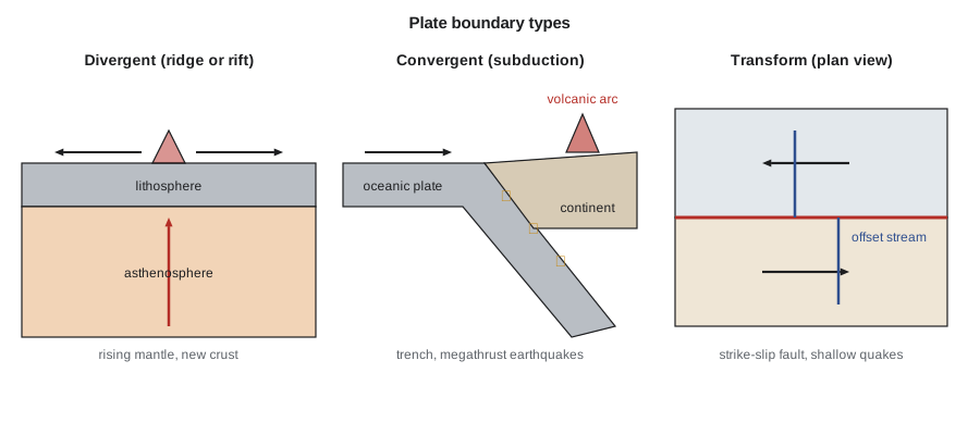
Western Canada sits across an active plate boundary. Off Vancouver Island, the small Juan de Fuca plate subducts beneath North America along the Cascadia subduction zone, which last produced a great earthquake of about magnitude 9 in January 1700. Farther north, the Pacific plate slides past North America along the Queen Charlotte Fault, which produced a magnitude 8.1 earthquake in 1949. The interior of the continent is far more stable, but even eastern Canada has moderate earthquakes along old zones of weakness, for example in the St. Lawrence valley and the Ottawa region. Kamloops lies inland of the most active zone, but the hospital design still has to account for ground shaking from distant large earthquakes and closer moderate ones.
Geologic time
The Earth is about 4.6 billion years old. Geologists divide this history into eons, eras, periods and epochs based on changes in fossils and major events, and they assign absolute ages from the decay of radioactive isotopes. For engineers, two lessons from geologic time are especially useful. First, slow processes become powerful over long times: a fault slipping a few millimetres per year accumulates kilometres of offset, and streams eroding a fraction of a millimetre per year can carve canyons. Second, the youngest deposits, those of the Quaternary period covering roughly the last 2.6 million years, are the ones engineers most often build on. In Canada and the northern United States, the Quaternary is dominated by repeated glaciations, which left behind till, outwash gravel, lake clays and other deposits that we study in lesson 6.
| Unit | Approximate age range | Notes for engineers |
|---|---|---|
| Precambrian | 4,600–541 million years ago | Ancient, hard igneous and metamorphic rocks of the Canadian Shield |
| Paleozoic Era | 541–252 million years ago | Limestones, dolostones, sandstones and shales of the continental interior |
| Mesozoic Era | 252–66 million years ago | Includes the Cretaceous shales that swell and slide in the western plains |
| Cenozoic Era (Tertiary part) | 66–2.6 million years ago | Mountain building in the west; volcanic rocks such as the Columbia River basalts |
| Quaternary Period | 2.6 million years ago to present | Glacial and postglacial soils; most foundations are built on these |
A useful habit is to ask, for any deposit, what process formed it and how long ago. A soft clay that settled in a glacial lake ten thousand years ago has had little time to be compressed by later loads, so it may be normally consolidated and weak. A shale of the same composition that has been buried under kilometres of sediment for a hundred million years and then exposed by erosion will be much stronger, but it may also swell and soften when it is unloaded and wetted. The age and history of a material are part of its engineering properties.
Rates of geologic processes
Many hazards are matters of rate. Plate motions are typically 2 to 10 centimetres per year. Creeping landslides may move millimetres to metres per year, while catastrophic slides can travel tens of metres per second. Erosion of a soft river bank may be metres per year; erosion of granite may be a few millimetres per thousand years. Engineers often have to translate a rate into a consequence over the design life of a structure, and simple arithmetic is enough to show whether a process matters.
Worked problem
Movement across a fault and a creeping slope
(a) Over geologic time, a strike-slip fault has an average slip rate of 6 mm per year. How much offset accumulates in 10,000 years? (b) An inclinometer on the old landslide at the highway site shows 18 mm of movement in 14 months. If this continues, how much movement will a culvert crossing the slide experience over a 75-year design life?
Show solution
- (a) Offset is rate times time:
- \[d = 6\ \text{mm/yr} \times 10\,000\ \text{yr} = 60\,000\ \text{mm} = 60\ \text{m}\]
- (b) Convert the observed movement to an annual rate:
- \[v = \frac{18\ \text{mm}}{14/12\ \text{yr}} = 15.4\ \text{mm/yr}\]
- Movement over 75 years at the same rate:
- \[d_{75} = 15.4 \times 75 = 1160\ \text{mm} \approx 1.2\ \text{m}\]
Answer: (a) About 60 m of offset. (b) About 1.2 m over the design life, far too much for a rigid culvert; the design must either stabilize the slide or use a flexible, maintainable crossing.
Priya checks this kind of calculation with a short program. Because rates measured over a few months can be affected by seasonal groundwater changes, she also compares the rate in wet and dry seasons before extrapolating.
# Extrapolating slow geologic movements
fault_rate_mm_yr = 6.0
years = 10_000
print(f"Fault offset in {years:,} years: {fault_rate_mm_yr * years / 1000:.0f} m")

# Inclinometer readings on the old landslide: (months since baseline, cumulative mm)
readings = [(0, 0.0), (3, 2.1), (6, 8.9), (9, 11.0), (12, 13.2), (14, 18.0)]
months, mm = readings[-1]
rate = mm / (months / 12)
print(f"Average rate: {rate:.1f} mm/yr")
for life in (25, 50, 75):
    print(f"  movement over {life} years: {rate * life / 1000:.2f} m")

# Seasonal check: compare the wet (spring) and dry (late summer) intervals
wet = (readings[2][1] - readings[1][1]) / 3 * 12
dry = (readings[4][1] - readings[3][1]) / 3 * 12
print(f"Annualized rate in spring interval: {wet:.1f} mm/yr; in dry interval: {dry:.1f} mm/yr")Fault offset in 10,000 years: 60 m Average rate: 15.4 mm/yr movement over 25 years: 0.39 m movement over 50 years: 0.77 m movement over 75 years: 1.16 m Annualized rate in spring interval: 27.2 mm/yr; in dry interval: 8.8 mm/yr
How engineering geology fits into a project
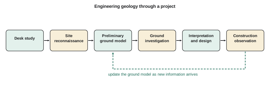
On a typical project the engineering geology work follows a sequence. A desk study collects existing information: geological maps, previous borehole records, air photos, lidar, well logs, hazard maps and local knowledge. A site reconnaissance by an experienced geologist walks the site, looks at exposures, landforms, seepage, vegetation and signs of instability. The ground investigation then tests the preliminary ground model with boreholes, test pits, geophysics and laboratory testing. The results are interpreted in a report that describes the ground model, gives design parameters and identifies hazards and uncertainties. During construction, the model is checked against what the excavations actually reveal, and design changes are made where the ground differs.
The geological model is not a one-time product. On the highway realignment, Ingrid's first model, based on a provincial map and lidar, showed the landslide as a single shallow slide in glacial lake silts. Boreholes later found that the slide surface was deeper than expected and followed a thin layer of clay at the contact with older gravels. The design changed from a simple drainage scheme to a combination of horizontal drains and a buttress. Each stage of investigation reduced uncertainty, and each was worth its cost because it changed a decision.
Professional practice and regulation
In Canada, the practice of geoscience is regulated provincially in the same way as engineering. A professional geoscientist (P.Geo.) or professional engineer (P.Eng.) takes responsibility for geological and geotechnical work, and in British Columbia both are regulated by Engineers and Geoscientists BC. Many engineering geologists hold both designations. Provincial highway authorities, municipalities and building codes require that site investigations and hazard assessments be prepared or reviewed by a qualified professional, and some types of work, such as landslide assessments for subdivision approval, have published professional practice guidelines that set out what a competent assessment includes.
Regardless of jurisdiction, the ethical duty is the same: to report ground conditions and their uncertainty honestly, to state the limits of the investigation, and not to let schedule or budget pressure turn a guess into a confident-sounding conclusion.
Common mistakes
MistakeTreating the ground beneath a site as uniform because the few boreholes looked similar.
InsteadUse geological reasoning about how the deposits formed to predict what may lie between test locations, and investigate where the model suggests variability.
MistakeAssuming that earthquakes happen only at plate boundaries.
InsteadMost large earthquakes are at plate boundaries, but moderate damaging earthquakes also occur within plates along old faults.
MistakeExtrapolating a few months of monitoring as if the rate were constant.
InsteadCheck for seasonal and groundwater-driven variation before projecting slope or settlement rates over a design life.
MistakeThinking geology matters only for tunnels and dams.
InsteadFoundations, cuts, pavements, pipelines and water supply all depend on the ground model; small projects fail on unexpected ground too.
Summary and key terms
- Engineering geology predicts ground conditions and geologic hazards for a particular project and design life.
- The Earth has a crust, mantle and core; mechanically, a rigid lithosphere moves as plates over the weaker asthenosphere.
- Plates meet at divergent, convergent and transform boundaries, each with characteristic earthquakes, volcanism and landforms.
- Most civil works are founded on Quaternary deposits, which in Canada and the northern United States are largely glacial.
- Geologic processes operate at rates from millimetres per year to metres per second; simple rate calculations show whether they matter over a design life.
- The ground model is built in stages, from desk study to construction, and must be updated as new information arrives.
- Engineering geology
- The application of geology to the location, design, construction and maintenance of engineering works.
- Ground model
- A three-dimensional description of the materials, structures and groundwater beneath a site, with their properties and uncertainties.
- Lithosphere
- The rigid outer shell of the Earth, made of the crust and uppermost mantle, broken into plates.
- Asthenosphere
- The hot, weak zone of the upper mantle on which the plates move.
- Subduction zone
- A convergent boundary where one plate sinks beneath another into the mantle.
- Transform fault
- A plate boundary where plates slide horizontally past each other.
- Quaternary
- The most recent geologic period, about the last 2.6 million years, marked by repeated glaciations.
- Desk study
- The collection and review of existing information about a site before field investigation.
Practice problems
Work each problem on paper first, then reveal the answer to check.
Name the three types of plate boundary and one hazard typical of each.
Show answer
Divergent: normal faulting and volcanism; convergent: megathrust earthquakes and explosive volcanoes; transform: shallow strike-slip earthquakes.
A plate moves 45 mm per year. How far does it move in one million years?
Show answer
\(45\ \text{mm} \times 10^6 = 45\ \text{km}\).
Why are glacial deposits so important to engineers in Canada and the northern United States?
Show answer
Most foundations, cuts and pavements in these regions are built on or in Quaternary glacial and postglacial deposits.
What is the difference between the crust and the lithosphere?
Show answer
The crust is a chemical layer; the lithosphere is a mechanical layer that includes the crust and the rigid uppermost mantle.
An inclinometer shows 9 mm of movement in 6 months. Estimate movement over 50 years if the rate continues.
Show answer
Rate \(= 18\) mm/yr, so about \(0.9\) m in 50 years.
List the main stages of engineering geology work on a project.
Show answer
Desk study, reconnaissance, ground investigation, interpretation and reporting, and construction observation with updating of the model.
Lesson quiz · 5 questions
Score 60% or more to complete this lesson.
Create a free account to save your progress, take quizzes and earn a certificate.