
PET-210 · Lesson 6 of 12 · 20 min
Migration, seals and fluid contacts
The geochemistry shows that the Bakken shales generated large amounts of oil. Much of it never moved far: it filled the middle member and the Three Forks just below, which is why those tight rocks are full of oil across the deep basin. But some oil escaped upward and sideways into conventional reservoirs, and in the Permian Basin and the Gulf of Mexico oil and gas have traveled kilometers from their sources. Nadia sketches arrows on her cross-section. 'Oil is lighter than water, and it never stops trying to rise,' she says. 'Our job is to find the places where something stopped it, or where it never left.' This lesson covers how petroleum leaves its source, how it moves, and how seals hold it.
Primary migration: leaving the source
Primary migration, also called expulsion, is the movement of oil and gas out of the fine-grained source rock into more permeable carrier beds. It is the least understood step of the petroleum system because it happens through pores only nanometers across. As kerogen cracks, the products occupy more volume than the solid they came from, and pressure builds within the source rock. When the pressure is high enough, tiny fractures open and petroleum escapes; as fluids leave, the pressure drops, the fractures close, and the cycle repeats. Petroleum may also move as a continuous oil phase along networks of organic matter, which in a rich source rock can form connected paths.
Expulsion efficiency, the fraction of generated petroleum that leaves the source rock, varies widely. Rich, oil-prone source rocks may expel more than half of their oil once they reach peak generation, while lean or gas-prone rocks retain more. What stays behind is the target of shale and tight-oil plays. Thin source beds interlayered with sandstones or siltstones expel efficiently because the distance to a carrier is short; thick, homogeneous shales expel less from their centers.
Secondary migration: traveling through the basin
Once in a carrier bed, petroleum moves by secondary migration. The main driving force is buoyancy: oil and gas are less dense than the water that fills the pores, so they rise. Water flow in the basin can help or hinder this, and capillary forces, which resist the entry of oil into small water-filled pores, control where oil can and cannot go. Oil migrates as thin stringers occupying only a small fraction of the pore space, following the steepest upward routes along the top of carrier beds, much as smoke follows the underside of a sloping ceiling.
Migration distances range from a few meters to hundreds of kilometers. In foreland basins with gently dipping, continuous carrier beds, such as the Western Canada basin, oil can travel very far toward the shallow edge of the basin. In faulted basins, migration may be short and vertical, along faults that act as conduits while they are active. Mapping the likely migration pathways, by drawing flow lines perpendicular to the structure contours on the top of the carrier bed, shows which traps sit on a route from the kitchen and which are in a migration shadow, unreachable no matter how good they look.
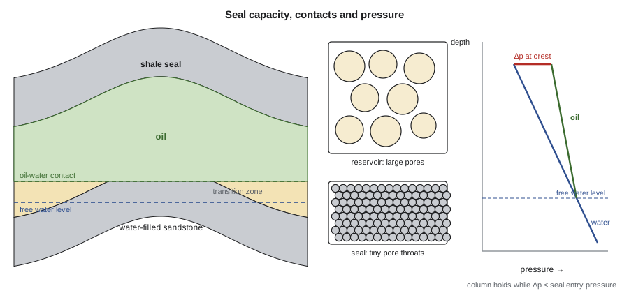
Seals and capillary pressure
A seal stops petroleum because its pores are too small for oil or gas to enter. Water wets the mineral surfaces, and pushing a non-wetting fluid such as oil into a water-filled pore throat requires a pressure difference, called the capillary entry pressure or displacement pressure. The smaller the pore throat, the greater the pressure needed. Shales, with throats measured in nanometers, need pressures of hundreds to thousands of kilopascals; sandstones, with throats of micrometers, need only a few kilopascals.
In this relation, γ is the interfacial tension between oil and water, θ the contact angle measured through the water, and r the pore throat radius. Below a trapped oil column, oil and water pressures are equal at the free water level. Above it, the oil pressure exceeds the water pressure by the buoyancy pressure, which grows with height because oil is lighter than water. The column can grow until the buoyancy pressure at its top equals the seal's entry pressure. Any more oil then leaks through the seal, and the trap stays full only to that height.
This is the capillary seal capacity. Gas columns are generally shorter than oil columns under the same seal, because gas is much lighter, so the buoyancy pressure grows faster with height, and because gas-water interfacial tension is higher, which partly offsets the effect. Seals can also fail in other ways: by fracturing when fluid pressure exceeds the rock's strength, called hydraulic seal failure, and by leakage along faults.
# Maximum hydrocarbon column a shale seal can hold, from capillary entry pressure
import math
G = 9.81
RHO_W = 1050.0                         # formation water, kg/m3
FLUIDS = {"oil": (800.0, 0.025), "gas": (250.0, 0.050)}   # density kg/m3, interfacial tension N/m (reservoir conditions)
THETA = 0.0                            # contact angle through water, degrees (strongly water-wet)
R_RES = 5e-6                           # reservoir pore throat radius, m (5 micrometers)

def pc(gamma, r):
    return 2 * gamma * math.cos(math.radians(THETA)) / r     # Pa

print("seal throat radius   oil column (ft)   gas column (ft)")
for r_nm in (50, 20, 10, 5):
    r = r_nm * 1e-9
    cols = []
    for name, (rho, gamma) in FLUIDS.items():
        h = (pc(gamma, r) - pc(gamma, R_RES)) / ((RHO_W - rho) * G)
        cols.append(h)
print(f" {r_nm:3d} nm {cols[0] * 3.281:9,.0f} {cols[1] * 3.281:9,.0f}")seal throat radius oil column (ft) gas column (ft)
50 nm 1,324 828
20 nm 3,331 2,082
10 nm 6,676 4,172
5 nm 13,365 8,353The program shows how sensitive seal capacity is to pore throat size. Halving the throat radius doubles the entry pressure and roughly doubles the column. It also shows why gas columns are shorter: the density contrast between gas and water is about three times that between oil and water, and the higher gas-water interfacial tension only partly offsets it. On these idealized numbers, a shale with throats of a few tens of nanometers can hold several hundred meters of oil, and a tighter one more than a kilometer; real seals have a range of throat sizes, imperfect wetting and fractures, so measured capacities are usually lower. Even so, many traps are limited by their geometry, their spill point, rather than by their seal.
Types of seals
Seals are classified by their rock type and by their position. Regional seals, such as thick marine shales or evaporite layers, extend across large parts of a basin and confine petroleum systems beneath them. Local seals cap individual traps. Fault seals form where a fault places a reservoir against an impermeable rock, or where the fault zone itself is filled with clay smeared from shale beds dragged along it. Evaporites, especially salt, are the most effective seals, followed by organic-rich and clay-rich shales, tight carbonates and cemented sandstones.
Fault seal analysis estimates whether a fault will hold petroleum. Geologists map which layers face each other across the fault, called the juxtaposition, using a diagram of the fault plane. Where sand faces shale, the fault is likely to seal. Where sand faces sand, sealing depends on the fault rock: the shale gouge ratio, the fraction of shale in the rock that has slipped past a point on the fault, is a widely used predictor, with higher values meaning better sealing. Fault seals matter enormously in faulted deltas such as the Gulf of Mexico and the Niger Delta, where many traps depend on them.
Fluid contacts and transition zones
In a trap, gas, oil and water separate by density into layers. The surfaces between them are the gas-oil contact and the oil-water contact. They are rarely sharp. Capillary forces hold water in the small pores above the free water level, so water saturation decreases gradually upward through a transition zone, which may be a few meters thick in a coarse sandstone and tens of meters in a tight rock. The oil-water contact recorded on logs is usually where water saturation reaches a value at which oil begins to flow, somewhat above the free water level where capillary pressure is zero.
Pressure measurements identify contacts more reliably than logs. A formation tester measures pressure at several depths in a well; plotted against depth, the points fall on straight lines whose slopes are the fluid pressure gradients: about 9.8 kPa/m (0.433 psi/ft) for fresh water, around 10.5 kPa/m (0.46 psi/ft) for saline formation water, roughly 7 to 8 kPa/m for oil and 1 to 3 kPa/m for gas. The intersection of the water line and the oil line marks the free water level. Engineers use these plots to locate contacts, test whether different wells share the same pressure system, and detect barriers between compartments.
Worked problem
Finding the free water level from pressures
A formation tester in an appraisal well into a conventional sandstone above the Bakken measures oil pressures of 2,180 psi at 5,040 ft and 2,228 psi at 5,190 ft. Nearby wells establish a water gradient of 0.45 psi/ft and a water pressure of 2,330 psi at 5,350 ft. Find the oil gradient and the free water level.
Show solution
- Oil gradient = (2,228 − 2,180)/(5,190 − 5,040) = 48/150 = 0.32 psi/ft.
- Oil line: P_o = 2,180 + 0.32 (z − 5,040). Water line: P_w = 2,330 + 0.45 (z − 5,350).
- Set equal: 2,180 + 0.32z − 1,613 = 2,330 + 0.45z − 2,408, so 567 + 0.32z = −78 + 0.45z.
- Solve: 0.13z = 645, so z = 4,962 ft.
Answer: The calculated free water level, about 4,962 ft, lies above both oil measurements, which is impossible: oil cannot be found below the free water level. The pressures therefore show that this well is not in the same pressure system as the nearby water wells. Lena flags a possible barrier or a different, deeper water level, and the team plans another test before committing to a development plan.
The example is deliberately awkward. Pressure data often reveal that a field is divided into compartments, by faults or by shale layers, each with its own contact. Recognizing compartments early prevents costly mistakes, such as assuming one well can drain a volume it is not connected to.
Contacts are not always flat. Where formation water flows through a reservoir, driven by recharge in distant highlands, the water pressure gradient pushes on the oil and tilts the oil-water contact in the direction of flow. Such hydrodynamic traps are known in parts of the Rocky Mountain foreland, and a tilted contact can move oil away from the crest of a structure or hold oil against a slope where no structural closure exists. A tilt of a few meters per kilometer may seem small, but across a large field it can shift the volume and the best well locations considerably, so a tilted contact on pressure data should never be dismissed as measurement error.
What happens to oil in the trap
Oil in a trap is not frozen in place. Gas can be added later from deeper, more mature source rocks, displacing oil downward. Uplift reduces pressure, so gas comes out of solution and may expand to push oil out of the trap. Near the surface, where groundwater carries oxygen and bacteria, oil is biodegraded: bacteria consume the lighter molecules and leave heavy, viscous oil rich in asphaltenes and sulfur. The world's largest examples are the oil sands of northern Alberta, where oil that migrated hundreds of kilometers updip was degraded near the surface into bitumen, and the heavy oils of the Orinoco belt in Venezuela.
Other processes alter oil too. Water washing removes soluble compounds. Thermal cracking at high temperature converts oil to gas and leaves solid bitumen in the pores. Deasphalting, when gas is added to oil, precipitates asphaltenes that can plug pores. Each process leaves geochemical clues that help geologists reconstruct the history of the trap, and each changes the fluid properties that engineers must design for.
Common mistakes
MistakeAssuming every trap on a map is charged.
InsteadA trap must lie on a migration route from a mature kitchen, and the trap must have existed when the oil passed.
MistakeEquating the log oil-water contact with the free water level.
InsteadCapillary forces hold water above the free water level; the transition zone may be thick in tight rocks.
MistakeAssuming a good seal can hold any column.
InsteadSeal capacity depends on pore throat size and fluid densities; gas columns are shorter than oil columns.
MistakeTreating separate wells as one pressure system without testing.
InsteadPressure-depth plots often reveal compartments with different contacts.
Summary and key terms
- Primary migration expels petroleum from the source rock, often through pressure-driven microfractures; what stays behind is the target of tight and shale plays.
- Secondary migration is driven by buoyancy and controlled by capillary forces; oil follows the steepest upward routes along carrier beds.
- Seals hold petroleum because their tiny pore throats require high capillary entry pressure; seal capacity sets the maximum column height.
- Fault seals depend on juxtaposition and fault rock; the shale gouge ratio is a common predictor.
- Contacts are gradational; pressure-depth plots identify free water levels and compartments.
- Oil can be altered in the trap by gas addition, biodegradation, water washing and thermal cracking.
- Primary migration
- The expulsion of petroleum from a source rock into a carrier bed.
- Secondary migration
- The movement of petroleum through carrier beds to traps, driven mainly by buoyancy.
- Capillary entry pressure
- The pressure needed to force a non-wetting fluid into a water-filled pore throat.
- Seal capacity
- The maximum column of oil or gas a seal can hold before leaking.
- Free water level
- The depth at which oil and water pressures are equal and capillary pressure is zero.
- Shale gouge ratio
- The fraction of shale that has slipped past a point on a fault, a predictor of fault seal.
- Biodegradation
- The alteration of oil by bacteria, removing light molecules and leaving heavy oil.
Practice problems
Work each problem on paper first, then reveal the answer to check.
A seal has a capillary entry pressure of 800 kPa for oil and the reservoir entry pressure is negligible. With water density 1,050 kg/m³ and oil density 800 kg/m³, what is the maximum oil column?
Show answer
h = 800,000/((1,050 − 800) × 9.81) = 326 m.
Why are gas columns usually shorter than oil columns under the same seal?
Show answer
Gas is much less dense, so the buoyancy pressure grows faster with height, reaching the seal's entry pressure sooner.
What does a sand-against-sand juxtaposition across a fault suggest, and what else must be checked?
Show answer
The fault may leak; the clay content of the fault rock, estimated by the shale gouge ratio, decides whether it seals.
Name two ways oil can be altered after it reaches a trap.
Show answer
Biodegradation by bacteria near the surface, and thermal cracking to gas at high temperature (also water washing, gas addition, deasphalting).
Lesson quiz · 5 questions
Score 60% or more to complete this lesson.
Create a free account to save your progress, take quizzes and earn a certificate.