
CIV-250 · Lesson 7 of 12 · 22 min
Traverses: closure and the compass rule
A traverse is a series of connected lines whose lengths and directions are measured, running from point to point across a site. It is the classic method of establishing horizontal control, and even in the age of GNSS it remains essential where satellite signals are blocked by trees, buildings or terrain, inside tunnels and buildings, and wherever the highest relative accuracy between nearby points is needed. This lesson covers the kinds of traverses, field procedure, the angular and linear checks that closed traverses provide, the computation of latitudes and departures, and the compass rule adjustment that produces final coordinates.
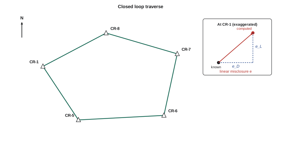
For the Coulee Ridge subdivision, Grant's crew runs a closed loop traverse around the site from control point CR-1, whose coordinates and the azimuth to CR-5 were established with GNSS, through four new points, CR-5 to CR-8, and back to CR-1. The traverse uses a project coordinate system with CR-1 at northing 5000.000 m and easting 1000.000 m. Leah computes and adjusts it; her work is the worked example of this lesson.
Kinds of traverses
- A closed loop traverse starts and ends at the same point. It provides checks on the angles and on the computed coordinates, but a loop alone cannot reveal a systematic error that scales all distances equally, such as a wrong prism constant applied consistently, or a wrong starting azimuth, because the shape still closes.
- A connecting or link traverse starts at one known point and ends at a different known point, ideally with known azimuths at both ends. It checks the angles, the distances and the scale and orientation of the whole survey, and it is the preferred form for route surveys and for tying projects to existing control.
- An open traverse ends at an unknown point and provides no check at all. Open traverses should be avoided except for rough or temporary work, and even then the lines should be measured twice.
Field procedure
At each traverse station, the total station is set up and centred, and the angle right from the previous station (the backsight) to the next station (the foresight) is measured on both faces, usually in several sets. Distances to the backsight and foresight are measured, so each line is measured from both ends and the two values can be compared. Targets are set on tripods with tribrachs over the points, and forced centring is used where possible, as described in lesson 6. Short lines are avoided, because centring errors produce large angular errors on short sights.
For a closed polygon, crews usually measure interior angles. With the traverse run counterclockwise around the figure, the angles right measured from backsight to foresight are the interior angles; with the traverse run clockwise, they are the exterior angles, which sum to \((n + 2) \times 180°\). Either way works, but the computation must follow consistently.
Angular closure
The interior angles of any closed polygon with \(n\) sides must sum to \((n - 2) \times 180°\). The difference between the sum of the measured angles and this value is the angular misclosure. Specifications limit it to a value that grows with the square root of the number of angles, for example \(10''\sqrt{n}\) for good engineering control or larger values for lower-order work.
If the misclosure is acceptable, it is usually distributed equally among the angles, since each was measured with similar care. If one angle was measured under poor conditions, for example with a very short sight, it can receive more of the correction. After adjustment, azimuths are computed around the traverse, and the last computed azimuth must return exactly to the starting azimuth, which checks the arithmetic.
Latitudes and departures
Each traverse line is resolved into components along the north and east axes. The latitude is the north component, positive northward, and the departure is the east component, positive eastward:
For a closed loop, the latitudes and departures must each sum to zero, because the traverse returns to its starting point. For a link traverse, they must sum to the difference between the known coordinates of the end and start points. The amounts by which they fail are the misclosures in latitude and departure, \(e_L\) and \(e_D\). The linear misclosure and the relative precision are:
Relative precision is usually written as a ratio such as 1:20,000, meaning one unit of misclosure for every 20,000 units of distance travelled. Typical requirements range from about 1:5,000 for rough construction work to 1:20,000 or better for engineering control, and much better for geodetic work. Modern total stations routinely achieve 1:50,000 or better on carefully run traverses.
The compass rule
The compass rule, also called the Bowditch rule, distributes the misclosures in latitude and departure in proportion to the lengths of the lines. It assumes that angles and distances are measured with similar relative precision, which is reasonable for total station traverses. The corrections to line \(i\) are:
The corrected latitudes and departures are then accumulated from the starting coordinates to give the coordinates of each point. The final computed coordinates of the closing point must equal its known coordinates, which is a check on the arithmetic. Other rules exist, such as the transit rule, which distributes corrections in proportion to the latitudes and departures themselves, but the compass rule is the most common simple method. For important control, least squares adjustment is now standard, because it handles any network shape, weights each measurement according to its precision and gives the precision of every adjusted coordinate.
Worked problem
Adjusting the Coulee Ridge loop traverse
The measured interior angles are CR-1 84°07′32″, CR-5 120°33′58″, CR-6 105°18′35″, CR-7 93°58′57″ and CR-8 136°01′10″. The measured horizontal distances are CR-1 to CR-5 373.537 m, CR-5 to CR-6 498.496 m, CR-6 to CR-7 365.687 m, CR-7 to CR-8 431.553 m and CR-8 to CR-1 415.638 m. The fixed azimuth of CR-1 to CR-5 is 146°23′31″, and CR-1 is at N 5000.000, E 1000.000. Adjust the traverse by the compass rule.
Show solution
- Angle sum: 540°00′12″. For five angles the sum should be \(3 \times 180° = 540°\), so the misclosure is +12″, within \(10''\sqrt{5} = 22''\). Each angle is corrected by \(-12''/5 = -2.4''\).
- Azimuths, each equal to the previous azimuth plus 180° plus the adjusted angle at the start of the line: CR-5 to CR-6 86°57′27″, CR-6 to CR-7 12°15′59″, CR-7 to CR-8 286°14′54″, CR-8 to CR-1 242°16′01″; continuing to CR-1 gives back 146°23′31″, which checks.
- Latitudes and departures, in metres: CR-1 to CR-5 −311.098, +206.756; CR-5 to CR-6 +26.459, +497.793; CR-6 to CR-7 +357.338, +77.693; CR-7 to CR-8 +120.749, −414.316; CR-8 to CR-1 −193.418, −367.892.
- Sums: \(e_L = +0.031\) m and \(e_D = +0.034\) m. The total length is 2,084.911 m.
- \[e = \sqrt{0.031^2 + 0.034^2} = 0.046\ \text{m} \qquad \text{precision} = 1:\frac{2084.911}{0.046} \approx 1:45\,000\]
- Corrections are proportional to length; for CR-5 to CR-6: \(C_L = -0.031 \times 498.496/2084.911 = -0.007\) m and \(C_D = -0.034 \times 498.496/2084.911 = -0.008\) m.
- Accumulating corrected components from CR-1 gives CR-5 (4688.897, 1206.750), CR-6 (4715.349, 1704.535), CR-7 (5072.682, 1782.222) and CR-8 (5193.424, 1367.899), and the last line returns exactly to CR-1 (5000.000, 1000.000).
Answer: The traverse closes to 1:45,000, which easily meets a 1:20,000 specification, and the adjusted coordinates are listed above. The largest corrections, about 8 mm, go to the longest line.
# Closed loop traverse: angular adjustment, latitudes and departures, compass rule
import math

def dms(d, m=0, s=0): return d + m / 60 + s / 3600
def fmt(x):
    x %= 360; d = int(x); m = int((x - d) * 60); s = round(((x - d) * 60 - m) * 60)
    if s == 60: s, m = 0, m + 1
    if m == 60: m, d = 0, d + 1
    return f"{d:3d}°{m:02d}'{s:02d}\""

names = ["CR-1", "CR-5", "CR-6", "CR-7", "CR-8"]
angles = [dms(84, 7, 32), dms(120, 33, 58), dms(105, 18, 35), dms(93, 58, 57), dms(136, 1, 10)]
dist = [373.537, 498.496, 365.687, 431.553, 415.638]
az0, N0, E0 = dms(146, 23, 31), 5000.000, 1000.000
n = len(names)

mis = (sum(angles) - (n - 2) * 180) * 3600
print(f"angular misclosure {mis:+.1f}\" (allowable {10 * math.sqrt(n):.0f}\")")
adj = [a - mis / n / 3600 for a in angles]

az = [az0]
for i in range(1, n):
    az.append((az[-1] + 180 + adj[i]) % 360)
print("closing azimuth check:", fmt((az[-1] + 180 + adj[0]) % 360), "=", fmt(az0))

lat = [L * math.cos(math.radians(a)) for L, a in zip(dist, az)]
dep = [L * math.sin(math.radians(a)) for L, a in zip(dist, az)]
eL, eD, P = sum(lat), sum(dep), sum(dist)
e = math.hypot(eL, eD)
print(f"eL = {eL:+.4f} m, eD = {eD:+.4f} m, e = {e:.4f} m, precision 1:{P / e:,.0f}")

N, E = N0, E0
for i in range(n):
    N += lat[i] - eL * dist[i] / P
    E += dep[i] - eD * dist[i] / P
print(f"{names[i]}-{names[(i + 1) % n]} az {fmt(az[i])} lat {lat[i]:+9.3f} dep {dep[i]:+9.3f} -> {names[(i + 1) % n]} N {N:9.3f} E {E:9.3f}")angular misclosure +12.0" (allowable 22") closing azimuth check: 146°23'31" = 146°23'31" eL = +0.0311 m, eD = +0.0343 m, e = 0.0463 m, precision 1:45,024 CR-1-CR-5 az 146°23'31" lat -311.098 dep +206.756 -> CR-5 N 4688.897 E 1206.750 CR-5-CR-6 az 86°57'27" lat +26.459 dep +497.793 -> CR-6 N 4715.349 E 1704.535 CR-6-CR-7 az 12°15'59" lat +357.338 dep +77.693 -> CR-7 N 5072.682 E 1782.222 CR-7-CR-8 az 286°14'54" lat +120.749 dep -414.316 -> CR-8 N 5193.424 E 1367.899 CR-8-CR-1 az 242°16'01" lat -193.418 dep -367.892 -> CR-1 N 5000.000 E 1000.000
Finding blunders
If a traverse fails to close within tolerance, the cause is usually a single blunder rather than an accumulation of random errors. Two simple tricks help locate it before the crew returns to the field.
- An angle blunder: compute the coordinates forward from the start and backward from the end, using the unadjusted angles. The station where the two sets of coordinates agree is likely the one with the wrong angle, because a wrong angle rotates the rest of the traverse about that point.
- A distance blunder: compute the direction of the linear misclosure, \(\tan^{-1}(e_D / e_L)\). A single wrong distance shifts the traverse along the direction of that line, so the misclosure will be nearly parallel to the line containing the blunder, and its size will be close to the error.
Common blunders include a backsight on the wrong point, a misread or mistyped angle, a transposed digit in a distance, and a wrong instrument or target height entered in a three-dimensional traverse. Once found, the suspect measurement is remeasured, not simply corrected on paper.
Tying traverses to the reference system
A loop traverse closed on itself proves internal consistency, but it does not prove that its orientation and scale match the national or state reference system. For that, the traverse must start and end on control points of known coordinates, or include GNSS-positioned points, as described in lessons 9 and 10. The starting azimuth on the Coulee Ridge traverse came from GNSS positions of CR-1 and CR-5, which ties the traverse to the reference system in orientation. If the traverse distances are ground distances and the coordinates are meant to be grid coordinates, the distances must also be scaled to grid before computation; on the project coordinate system used here, which is scaled to ground, that step is not needed.
Three-dimensional traverses
Modern total stations measure zenith angles along with horizontal angles and distances, so a traverse can carry elevations as well as horizontal coordinates. The elevation difference on each line is computed by trigonometric levelling, as described in lesson 3, measured in both directions and averaged to reduce the effects of refraction and curvature. The sum of elevation differences around a loop should be zero, giving an elevation misclosure that can be adjusted much like a level loop. Traverse elevations are adequate for many purposes, but benchmarks for drainage design are still established by differential levelling.
Common mistakes
MistakeUsing exterior angles with the formula for interior angles.
InsteadCheck whether the traverse runs clockwise or counterclockwise, and use the right sum: interior angles sum to (n − 2) × 180°.
MistakeApplying latitude corrections with the same sign as the misclosure.
InsteadCorrections have the opposite sign to the misclosure, so that the adjusted components sum correctly.
MistakeAssuming a well-closed loop traverse is correctly oriented and scaled.
InsteadTie the traverse to known control or GNSS points; a loop cannot reveal a wrong starting azimuth or a uniform scale error.
MistakeAdjusting a traverse that misses tolerance.
InsteadFind and remeasure the blunder first; adjustment only distributes small random errors.
Summary and key terms
- Traverses may be closed loops, connecting traverses between known points, or open; open traverses have no check.
- Interior angles of a closed polygon sum to (n − 2) × 180°; acceptable angular misclosures are distributed equally.
- Latitude = L cos Az and departure = L sin Az; their sums give the misclosures in north and east.
- Linear misclosure divided into the traverse length gives the relative precision, such as 1:20,000.
- The compass rule distributes misclosures in proportion to line lengths; least squares is used for important control.
- The direction of the misclosure and forward and backward computations help locate distance and angle blunders.
- Traverse
- A series of connected lines whose lengths and directions are measured to establish positions.
- Closed loop traverse
- A traverse that starts and ends at the same point.
- Connecting traverse
- A traverse that runs between two different points of known position.
- Latitude
- The north component of a traverse line, positive northward.
- Departure
- The east component of a traverse line, positive eastward.
- Linear misclosure
- The distance between the computed and known positions of the closing point.
- Relative precision
- The linear misclosure expressed as a ratio of the total traverse length.
- Compass rule
- An adjustment that distributes misclosures in proportion to line lengths; also called the Bowditch rule.
Practice problems
Work each problem on paper first, then reveal the answer to check.
What should the interior angles of a seven-sided closed traverse sum to?
Show answer
\((7 - 2) \times 180° = 900°\).
A line 250.000 m long has an azimuth of 120°00′00″. Find its latitude and departure.
Show answer
Lat \(= 250\cos 120° = -125.000\) m; Dep \(= 250\sin 120° = +216.506\) m.
A traverse 1,850 m long has e_L = −0.024 m and e_D = +0.018 m. Find the linear misclosure and precision.
Show answer
\(e = 0.030\) m; precision 1:61,700.
In that traverse, what latitude correction does a 400 m line receive?
Show answer
\(+0.024 \times 400/1850 = +0.005\) m.
A traverse's linear misclosure points along azimuth 87°, close to the direction of one 520 m line, and is 0.32 m long. What do you suspect?
Show answer
A distance blunder of about 0.32 m on that line, which should be remeasured.
Why can a loop traverse close perfectly but still be wrongly oriented?
Show answer
Rotating the whole figure by a wrong starting azimuth does not change its shape, so the misclosure is unaffected.
Lesson quiz · 5 questions
Score 60% or more to complete this lesson.
Create a free account to save your progress, take quizzes and earn a certificate.